Tropical Storm Eta Tracks Through the Gulf of Mexico

Eta's cone
Tropical Storm Eta has continued its erratic and destructive journey through the Caribbean and the Gulf of Mexico, remaining a strong but rather disheveled tropical storm through the morning hours of November 9.
Although convection has waned substantially over the past few days, Eta still is producing some strong winds and heavy rain, and is still expected to strengthen a little more once it moves over the warm waters of the Loop Current tomorrow. Currently, Eta is sporting maximum winds of 65 mph and a pressure of 992 mbar.
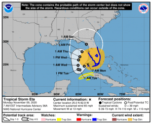
Although not as destructive as the impacts felt in Central America, Eta’s impacts in South Florida were still significant. Rainfall spread across the region over the weekend, with over a foot reported in some areas of South Florida. Additionally, its landfall over the Florida Keys last night further extended the season’s record to 12 landfalling US named storms in total.
Force Thirteen is also covering tropical cyclones around the world on their YouTube, Facebook and Twitter pages. Refer to the NHC or your local NWS office for the latest official information.
