Tropical Storm Fay strengthens, bringing flooding rains as it nears the US East Coast

Tropical Storm Fay still strengthening
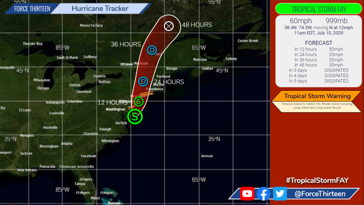
As of the 11 am EDT Advisory from the National Hurricane Centre, Tropical Storm Fay has strengthened further as it continues to move Northwards at around 12 mph. The storm has estimated winds of 60 mph at the current time, with a central pressure of 999 MB. At the time of writing, recent F13 estimates have placed the centre of Fay just 25 miles offshore, and we now expect a landfall to occur in approximately two hours along the New Jersey coast, near Atlantic City. It is unlikely that Fay will strengthen much further before moving ashore. After landfall, we expect Fay to begin accelerating towards the NNE as it moves through the New York City metro area and New England. Upon making landfall, weakening will commence, and we expect Fay to become a tropical depression in around 24 hours, before degenerating into a remnant low in 48 hours and dissipating soon thereafter.
Impacts from Tropical Storm Fay
Flash flooding in poorly-drained urban areas continues to be the primary impact from Fay, with rainfall rates widely over 1″ per hour where rainbands are tracking onshore. Almost 10″ of rain has been observed between 5:30 am and 12:30 pm EDT just South of Lewes, Delaware, while rainfall rates of over 1½” per hour have been recorded in Allentown, Pennsylvania. Flash flooding has been reported throughout New Jersey due to the heavy rains, with eyewitnesses estimating the level of inundation to be as much as 2′ in some places. Flash flood warnings are in effect, with the Weather Prediction Centre issuing a slight (10%) risk of flash flooding across parts of Delaware, Maryland, Pennsylvania, New York, Massachusetts, Rhode Island and all of Connecticut and New Jersey.
While Fay is packing strong and gusty winds, these will likely only cause minor tree damage, with the potential to blow away any objects not securely fastened. The greatest risk comes from the life-threatening surf conditions being generated by Fay, with rip-tides likely. Officials are encouraging beachgoers to remain out of the water, and only to enter the ocean if they have a floatation device with them. Later this evening, high tides are expected to combine with storm surge to produce minor coastal flooding: one to three feet of inundation above normally dry ground is expected. For more information, see products issued by your local weather service, and take the necessary precautions to stay safe when leaving your home.

Street flooding in #AvalonNJ #TropicalStormFay A few cars got caught in this. Turn around!!! pic.twitter.com/eYKPPv5fxQ
— Zeke Orzech (@Zeke_O) July 10, 2020
* #EastCoast: #Fay #TropicalStormFay #TSFay
–#NorthCarolina #Virginia #Delaware #Maryland #NewJersey #NewYork #NYC #NewYorkCity #LongIsland #RhodeIsland #Connecticut #Massachusetts #Maine #Quebec #Canada #Vermont #NewHampshire #USA
-BLOG/MAPS/SATELLITE:https://t.co/AX08RPltSB pic.twitter.com/g6JHFYnAZB— Let's Talk Tropics (@RoshinRowjee) July 10, 2020
Significance of Fay for the 2020 Atlantic Hurricane Season
Fay is the 6th named storm of the year so far in the 2020 Atlantic Hurricane Season. When it formed on July 9th, it became the earliest such storm on record, forming earlier than both Franklin and Emily of 2005, beating Franklin’s record by over 11 days and forming 2 days sooner than Emily. While this is very unusual, it is important to note that the total ACE (Accumulated Cyclone Energy) of the 2020 Atlantic Hurricane Season to-date is much lower than that of 2005 at this point, with just two storms from that season (Dennis and Emily) producing a combined total of over 60 ACE in early-mid July.
Despite the fact that we have not yet had a hurricane this year, we are still well ahead of climatology for the basin, indicating that the environmental conditions in the basin are incredibly favourable for tropical cyclogenesis. As we move closer to the start of peak season in early August, the Main Development Region will become an increasingly favourable environment and we should see the first tropical waves developing into tropical cyclones before the middle part of next month. Sea surface temperatures (SSTs) are widely above 30 Celsius in the Eastern Gulf of Mexico, through the Florida Straits and into the Bahamas, with a large pool of 30 Celsius SSTs and very high Oceanic Heat Content (OHC) in the Northern Caribbean off the Southern Coast of Cuba. This is an area which we will be watching very closely for potential rapid intensification of tropical cyclones later on in the season.
As always, the team at F13 will endeavour to bring you the very latest information on the tropics to keep you up-to-date on global events as they unfold live around the world.
