Tropical Storm Humberto forms near the Bahamas; Hurricane Kiko Rapidly Strengthens in the Pacific

Tropical Storm Humberto, the eighth named storm of the 2019 Atlantic hurricane season, formed near the disaster-stricken northwestern islands of the Bahamas on Friday. The storm has since strengthened and is forecast to become a hurricane later today or on Monday as it turns sharply northeastward out to sea and away from the Bahamas and Southeast U.S coast. Also a highlight today in the tropics is Hurricane Kiko, which rapidly intensified after struggling to intensify during the past few days under unfavorable environmental conditions. Currently a Category 3 hurricane, Kiko is forecast to remain over the open waters of the Eastern North Pacific Ocean and is no threat to land.
Tropical Storm Humberto: Current Information and Forecast
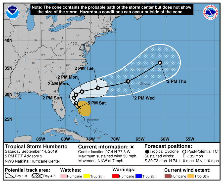
As of the most recent advisory from the National Hurricane Center (NHC) at 5:00 PM EDT (21:00 UTC) September 14, Tropical Storm Humberto is located near 27.4°N, 77.3°W, about 70 miles (115 km) north of Great Abaco Island, and about 105 miles (170 km) northeast of Freeport, Grand Bahama Island. Maximum sustained winds are near 50 mph (85 km/h), with gusts of up to 65 mph (100 km/h), and the minimum central pressure is 1005 mb (29.68 inches). Humberto is moving toward the north-northwest at 7 mph (11 km/h), and this general motion along with a gradual northward turn is forecast during the next day or so. Tropical storm-force winds extend outward up to 140 miles (220 km), mainly to the north and east of the center. Heavy rainfall and strong gusts associated with Humberto are currently affecting parts of the northwestern Bahamas, although they are forecast to subside today.
Moderate wind shear which was affecting Humberto and hindering intensification during the past couple of days is now decreasing as Humberto moves northward and over warmer waters. Due to these favorable conditions present, the NHC anticipates that Humberto will become a hurricane by Monday. Around that time, Humberto is also forecast to make a sharp turn to the northeast, which will keep the cyclone off the southeast coast of the United States. Virtually all of the numerical models show Humberto intensifying into a hurricane, with most showing further intensification to or near Category 2 strength on the Saffir-Simpson Scale. The NHC’s forecast reflects this and shows Humberto becoming a Category 2 hurricane by Tuesday as it begins to accelerate eastward. The global weather models also show an increase in the size of Humberto in addition to showing intensification. By mid-week, Humberto is forecast to be passing very close to the island of Bermuda as it begins a more northward turn. Although it is too early to determine if Humberto will bring significant impacts to Bermuda, residents there should closely monitor the progress of this tropical cyclone. Additionally, Humberto is expected to produce large swells along the East Coast of the United States, which could lead to life-threatening surf and rip current conditions.
Kiko Churns over the Eastern Pacific
Hurricane Kiko rapidly intensified today as it continued westward across the open waters of the Eastern North Pacific Ocean. The cyclone had been struggling to intensify during the past couple of days due to unfavorable conditions caused by a dry air mass. However, an inner core has since become better defined and has allowed the cyclone to take advantage of otherwise favorable conditions, including low wind shear and warm sea surface temperatures. Kiko quickly strengthened from a tropical storm with winds of 50 mph (85 km/h) to a Category 3 hurricane with winds of 115 mph (185 km/h) in just 24 hours, a remarkable intensification in such a short period of time.
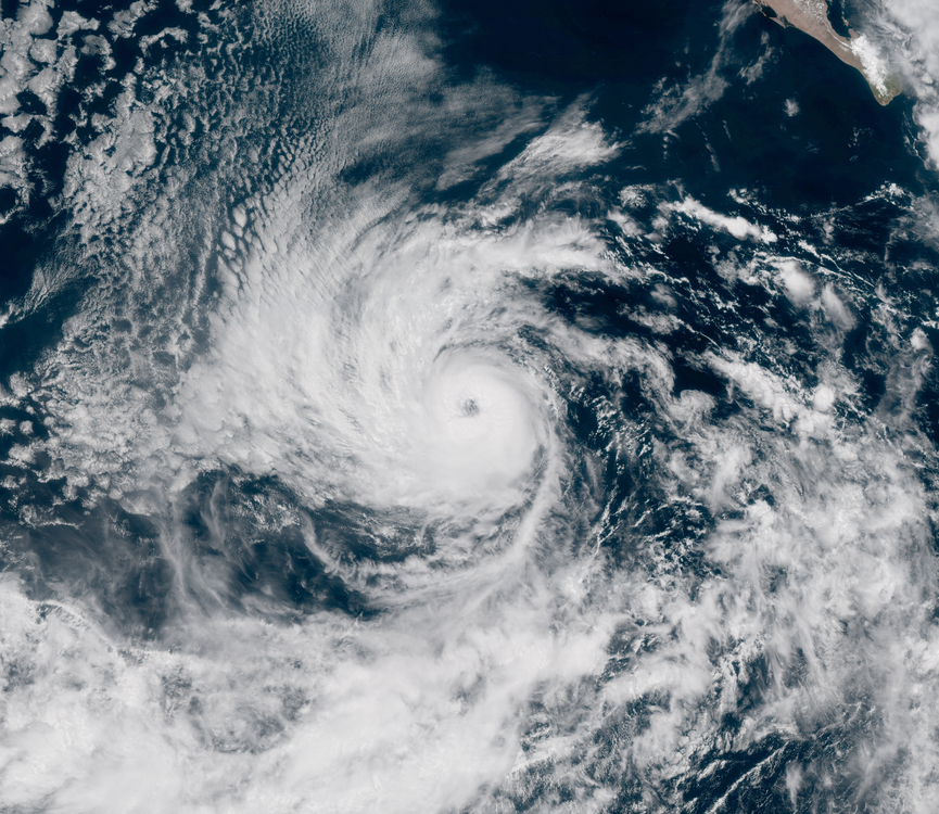
As of the NHC’s most recent advisory at 8:00 PM PDT (03:00 UTC) September 15, the eye of Hurricane Kiko was located near 17.0°N, 120.1°W, about 775 miles (1250 km) west-southwest of the southern tip of the Baja California Peninsula. Maximum sustained winds are near 115 mph (185 km/h), with gusts of up to 130 mph (215 km/h), and the minimum central pressure is 966 mb (28.53 inches). Some additional strengthening could occur today before a gradual weakening trend begins by Monday. Although powerful, Kiko is a very small hurricane. Hurricane-force winds only extend outward up to 15 miles (30 km) from the center, and tropical storm-force winds extend outward up to 70 miles (110 km) from the center. Kiko is moving toward the west at around 9 mph (15 km/h), and this general motion is forecast to continue for the next day or so. By Tuesday, Kiko is forecast to turn west-northwestward with a decrease in forward motion as a mid-level ridge steering the hurricane weakens. There are no tropical cyclone watches or warnings currently in effect, and Kiko is expected to remain over open waters with no threat to land whatsoever.
For more information regarding current activity in the tropics, visit Force Thirteen’s official outlets. Live updates and daily Tropical Weather Bulletins can be found at the official Force Thirteen YouTube channel, and further information can be found on the Force Thirteen Twitter and Facebook pages.
