Tropical Storm Ida continues to intensify, poised to hit western Cuba as a hurricane

Tropical Storm Ida continues to intensify further as it nears the western part of Cuba, where hurricane warnings were just issued for the incoming storm. Reconnaissance aircraft are also currently measuring Ida as of this post.
Ida is located at 20.8° north, 81.9° west, about 75 miles (125 kilometers) southeast of the Isle of Youth, with sustained winds of 65 mph (100 km/h) and a central pressure of 996 millibars, according to current Force Thirteen analysis. The storm is currently moving northwest at 15 mph and is, again, continuing to intensify. The storm currently has a CDPS (Cyclone Destruction Potential Scale) rating of 5, meaning devastating damage is possible for the western part of Cuba.

Current watches and warnings
A Hurricane Warning, meaning that hurricane conditions are expected somewhere within the warning area (in Ida’s case, within the next 12 hours), is in effect for:
- Cuban provinces of Pinar del Rio and Artemisa, and the Isle of Youth
A Hurricane Watch, typically issued 48 hours before the anticipated first occurrence of tropical-storm-force winds, conditions that make outside preparations difficult or dangerous, is in effect for:
- Cameron, Louisiana to the Mississippi/Alabama border
- Lake Pontchartrain, Lake Maurepas, and Metropolitan New Orleans
A Tropical Storm Warning, meaning that tropical storm conditions are expected somewhere within the warning area, is in effect for:
- Little Cayman and Cayman Brac
- Cuban provinces of Matanzas, Mayabeque, and Havana
A Tropical Storm Watch, meaning that tropical storm conditions are possible within the watch area (generally within 48 hours), is in effect for:
- Mississippi/Alabama border to the Alabama/Florida border.
What are the hazards being generated by Ida affecting land?
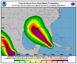
Current tropical storm force wind probabilities for Ida, according to the National Hurricane Center. A dangerous storm surge will raise water levels by as much as 4 to 6 feet above normal tide levels in areas of onshore winds along the immediate coast of the Isle of Youth and near and to the east of where the center crosses the coast of western Cuba. Near the coast, the surge will be accompanied by large and destructive waves.
The combination of a dangerous storm surge and the tide will cause normally dry areas near the coast to be flooded by rising waters moving inland from the shoreline.
- Tropical storm conditions are expected on Little Cayman and Cayman Brac through early this afternoon. Hurricane conditions are expected to reach the Isle of Youth and portions of western Cuba in the Hurricane Warning area by later this afternoon and evening, with tropical storm conditions beginning within the next couple of hours on the Isle of Youth.
Hurricane conditions are possible in the hurricane watch area along the northern Gulf coast late Saturday night or Sunday and tropical storm conditions are possible in the watch area late Saturday night or Sunday.
- Ida is expected to produce total rainfall accumulations of 6 to 10 inches with maximum totals of 15 inches across Jamaica. Rainfall totals of 8 to 12 inches with isolated maximum amounts of 20 inches are expected across the Cayman Islands and western Cuba, including the Isle of Youth. These rainfall amounts may produce life-threatening flash floods and mudslides.
As Ida approaches the central Gulf Coast Sunday afternoon, total rainfall accumulations of 8 to 16 inches with isolated maximum amounts of 20 inches are possible from southeast Louisiana to coastal Mississippi and Alabama through Monday morning. Ida is forecast to turn northeast as it moves inland later Monday with rainfall totals of 4 to 8 inches possible across southern and central Mississippi. This is likely to result in considerable flash, urban, small stream, and riverine flooding.
- Swells generated by this system will affect the Cayman Islands and Cuba through tonight. Swells will begin reaching portions of the northern Gulf coast Saturday night or early Sunday. These swells are likely to cause life-threatening surf and rip current conditions.
Please be safe for this storm, keep updated with your local officials, and evacuate if need to. Stay tuned for updates. You can always check our Cyclone Tracker text products for up-to-date information about Ida: Tropical Storm Ida » Text Products – Force Thirteen (force-13.com)
References:
- The National Hurricane Center’s Public Advisory #5 for Ida: Tropical Storm IDA (noaa.gov)
- The National Hurricane Center’s Tropical-Storm-Force Wind Probabilities for Ida: TROPICAL STORM IDA (noaa.gov)
