Tropical Storm Isaias Forms in the Northeastern Caribbean; Forecast to Strengthen with Impacts Likely for the Bahamas and United States

The broad area of disturbed weather that the National Hurricane Center (NHC) has been monitoring for the past few days as Potential Tropical Cyclone Nine has finally consolidated sufficiently to be classified as Tropical Storm Isaias (pronounced “ees-ah-EE-ahs”). It is the ninth named storm of the 2020 Atlantic hurricane season, and the record-tying fifth named storm in the month of July, following Tropical storms Edouard, Fay, and Gonzalo, and Hurricane Hanna. Isaias is also the earliest ninth-named storm for the North Atlantic in the historical record that extends back to 1851, surpassing the previous record set by Hurricane Irene of 2005, which formed on August 7. Isaias is currently located near the Dominican Republic, and is forecast to strengthen over the next several days as it moves westward, likely putting the Bahamas and the United States East Coast under threat for tropical storm and/or hurricane conditions.
Tropical Storm Isaias: Latest Storm Information
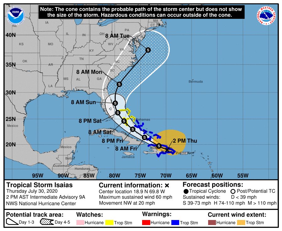
As of the National Hurricane Center’s most recent advisory on Isaias at 2:00 PM EDT (18:00 UTC), the center of Tropical Storm Isaias was located near 18.9°N, 69.8°W, about 95 mi (150 km) west-northwest of Punta Cana, Dominican Republic, and about 85 mi (140 km) southeast of Puerto Plata, Dominican Republic. Maximum sustained winds are near 60 mph (95 km/h) with gusts to 70 mph (110 km/h), the minimum central pressure is 1003 mb (29.62 inches), and tropical storm-force winds extend outward up to 310 miles (500 km) from the center. Isaias is moving toward the northwest at around 20 mph (31 km/h), and a slower west-northwestward to northwestward motion is expected over the next couple of days. On the forecast track, the center of Isaias will be near the southeastern Bahamas by late tonight or early Friday, and move near or over the northwestern Bahamas and the Florida coast over the weekend. Isaias is expected to strengthen over the next few days as it moves close to the U.S East Coast, and, although not currently explicitly forecast, it could become a hurricane over the weekend while moving through the Bahamas. By early next week, Isaias is forecast to turn northeastward and accelerate off the U.S East Coast, potentially impacting portions of the coast further north.
Forecast Track, Intensity Guidance, and Hazards Affecting Land
Over the next two days or so, Isaias is expected to move generally west-northwestward to northwestward, which the numerical model guidance is in good agreement on. The track of Isaias after that time becomes a little more uncertain: while the storm is likely to make a turn to the northeast at some point, there is less model consensus as to when and where this occurs. Most of the models showing a stronger cyclone show this recurve occuring earlier over the Bahamas, while those that show a weaker storm generally take Isaias near or into the Florida peninsula before a northeastward turn occurs. Isaias is very likely to strengthen over the next several days, although how much it strengthens is still rather uncertain, and largely due to uncertainty in the favorability of the ambient environment. Both the SHIPS guidance and the global models suggest that at least moderate southerly shear could dampen intensification over the next two days or so, and the dynamical model guidance is generally reflective of this. The NHC intensity forecast calls for Isaias to reach an intensity of 70 mph (110 km/h), and maintain that through Sunday before weakening slightly afterward.
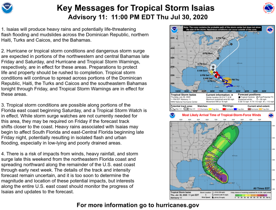
Isaias continues to produce heavy rains and potentially life-threatening flash flooding and mudslides across Haiti, the Dominican Republic, and Puerto Rico, and these hazardous conditions will expand into the southwestern Bahamas and eastern Cuba on Friday. Tropical Storm and possibly Hurricane conditions are expected in portions of the central and northern Bahamas late Friday and Saturday, and Tropical Storm Warnings are currently in effect for those islands. There is an increasing probability of hazardous hurricane and tropical storm conditions affecting much of the U.S East Coast this weekend and early next week. While the details of the track and intensity of Isaias remain uncertain, and it is too soon to determine the magnitude, time, and location of these impacts, interests along the entire U.S East Coast should closely monitor the progress of Tropical Storm Isaias.
External Links
Please refer to the National Hurricane Center and National Weather Service websites for further information regarding Tropical Storm Isaias as well as watches and warnings in effect. Force Thirteen will be providing live coverage on Isaias starting today in addition to regular updates. More information can be found at Force Thirteen’s official outlets, including its Twitter and Facebook pages.
