Tropical Storm Kimi rapidly forms near Australia; tropical low forming over the Gulf of Carpentaria

The Australian Region basin is now coming back with activity, as two tropical systems have recently formed, according to the Regional Specialized Meteorological Centre (RSMC) of the basin, the Bureau of Meteorology.
Tropical Cyclone Kimi has formed 6 hours ago, currently located near 15.4 degrees south, 146.5 degrees east, approximately 99 nautical miles to the north-northwest of Cairns in Australia. The storm currently has maximum sustained winds of 50 mph (85 km/h), with gusts up to 65 mph (100 km/h), and a pressure of 996 millibars, according to the Joint Typhoon Warning Center (JTWC).
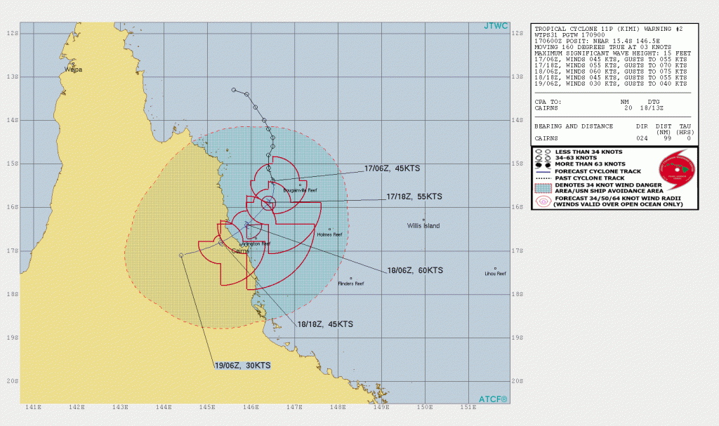
According to the Bureau of Meteorology (BoM), Kimi is a category 1 tropical cyclone on the Australian scale, with winds of 75 km/h (40 mph), with gusts up to 100 km/h (55 mph), and a pressure of 994 hectopascals (hPa). The storm is currently moving south-southwestwards at 3 knots (3 mph; 6 km/h) according to the JTWC.
The Bureau of Meteorology, through the Department of Transport and Main Roads (Queensland), had issued a Red alert, which means “destructive winds forecast within 6 hours”, for the following areas:
- Cooktown, Queensland,
- Port Douglas,
- Half Moon Bay, Cairns,
- Cairns,
- Innisfail, Queensland,
- and Mourilyan, Queensland.
People over the aforementioned areas must commence preparations or continue it, according to the agency.
Meanwhile, the agency has been monitoring a tropical low that is over the Gulf of Carpentaria. Tropical Low 08U is located near 11 degrees south, 137 degrees east, between Elcho Island and Nhulunbuy in the Northern Territory of Australia. The storm is expected to move westwards across the Timor Sea and enter the Indian Ocean on Wednesday.
Stay tuned for updates. You could also track Kimi on our Cyclone Tracker: https://www.force-13.com/cyclone-tracker/
References:
- The Joint Typhoon Warning Center’s text advisory on Kimi: https://www.metoc.navy.mil/jtwc/products/sh1121web.txt
- The Joint Typhoon Warning Center’s cone on Kimi: https://www.metoc.navy.mil/jtwc/products/sh1121.gif
- The Bureau of Meteorology’s Tropical Cyclone Forecast Map for Kimi: Tropical Cyclone Forecast Track Map Page (1) (bom.gov.au)
- The Department of Transport and Main Roads (Queensland)’s Red Alert warning for Kimi: Department of Transport and Main Roads (Queensland) – Home | Facebook
- The Bureau of Meteorology’s Northern Area High Seas Forecast: http://www.bom.gov.au/nt/forecasts/nahighseas.shtml
- The Bureau of Meteorology’s Tropical Cyclone Outlook for the Northern Region, including the Gulf of Carpentaria: http://www.bom.gov.au/nt/forecasts/tcoutlook.shtml
