Tropical Storm Sally Likely to Become a Hurricane on Monday

Overview
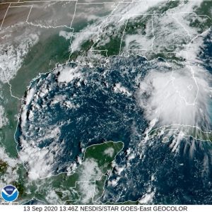
Tropical Storm Sally, the eighteenth named storm in the relentless 2020 Atlantic Hurricane Season will likely become a hurricane on approach to Louisiana and Mississippi on Monday. As of 7AM CDT on September 13, Sally was located at 27.3N and 84.6W with winds of 50mph and a pressure of 996 millibars, moving West-Northwest at 13mph, with rainbands battering the Western coast of Florida. Sally continues the record naming pace, as it became the earliest “S” named storm yesterday. All tropical cyclone related threats are possible including life-threatening rainfall, high storm surge and hurricane force winds will be possible with the greatest threat centered near Louisiana and Mississippi. Sally is poised to become the fourth US hurricane landfall of the season, a season which has brought the devastation of Laura and the impacts of Hanna on the Texan Gulf Coast. Preparations of supplies and shelters should be completed by tonight to ensure safety before hurricane force winds are felt tomorrow.
Watches and Warnings

Numerous watches and warnings are in place for areas of the Gulf Coast this morning, with a Storm Surge Warning for Port Fourchon Louisiana to the Mississippi/Alabama Border and Lake Pontchartrain, Lake Maurepas, and Lake Borgne. A Storm Surge Watch is in place for the Mississippi/Alabama Border to the Alabama/Florida Border. Hurricane Warnings are in effect for Grand Isle Louisiana to Ocean Springs Mississippi and areas of Lake Pontchartrain and Lake Maurepas including metropolitan New Orleans. Tropical Storm Warnings are also in effect East of Ocean Springs to Indian Pass.
Impacts
All tropical cyclone related hazards are possible from Sally. Impressive rainfall amounts, possibly exceeding 20 inches in some locations are likely. Rainfall amounts of 6 to 12 inches with isolated amounts of 20 inches over portions of the Central Gulf Coast between the western Florida Panhandle and far southeast Louisiana from Monday into the middle of the week. Rainfall of 4 to 8 inches is possible farther inland over portions of Mississippi and Alabama. Hurricane force wind gusts are likely on the Gulf Coast from Grand Isle Louisiana to Ocean Springs Mississippi and Lake Pontchartrain and Lake Maurepas including metropolitan New Orleans. Residents of New Orleans and areas under the hurricane warning should complete preparations by tonight before hurricane force wind gusts arrive. Storm surge will be highest from the Mouth of the Mississippi River to Ocean Springs including Lake Borgne where 7-11 ft of surge is likely. Areas from Port Fourchon to Mouth of the Mississippi River and Ocean Springs to MS/AL Border will receive 4 to 7 ft of surge, with similar amounts for Lake Pontchartrain and Lake Maurepas.
![[Image of cumulative wind history]](https://www.nhc.noaa.gov/storm_graphics/AT19/refresh/AL192020_peak_surge+png/095214_peak_surge.png)
Future updates on Tropical Storm Laura and future systems in the Atlantic basin can be found on the Force Thirteen Youtube channel, as well as our various social mediums on Twitter and Facebook.
