Tropical Storm Sarai is Going to Impact Fiji This Week

Tropical Storm Sarai has just been named today by the Fiji Meteorological Services at 1200 UTC December 26, 2019, and it is going to impact Fiji and all the other islands around Fiji for the next few days. Right now, Sarai has winds of 50mph and a pressure of 994mb and is moving south–southwest at 14mph. Also, gale warnings are in effect for Va Nua Levu, Taveuni, and other islands nearby while a strong wind warning is in effect for Rotuma. Luckily, no landfall is predicted for Fiji, but Sarai will get close to the island as it starts to turn southeast. The overall environment is conducive for continuing development as it gets closer to Fiji before higher levels of shear halts more development. The main impacts of the storm will be the high winds, the storm surge, and the rain as it makes its closest approach to Fiji.
Rainfall

Rainfall is nothing to take lightly if you live in northern Fiji then please at the Fiji Meteorological Services for further information. This storm will be moving fast, but it is such a huge system that the rainfall will pile up in isolated locations.
Intensity and Forecast
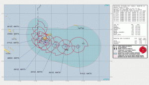
The track of the system is pretty clear, but the intensity guidance is not as clear. The intensity of Sarai all depends on how fast can Sarai tighten its inner core because it is such a massive system. Because of this no model is quite sure about how intense it will get, but the average seems to be somewhere around a cat 1.
Overall, tropical storm Sarai is threat to take seriously if you are in any of the warning areas the Fiji Meteorological Services have designated. If you are in the cone but no warnings have been placed yet than keep a close eye on the system and check the Fiji Meteorological every few hours to keep updated. Sarai will be a threat, but it is unlikely that it will be anything stronger than a cat 2.
Works Cited
- https://www.tropicaltidbits.com/ “Forecast Models, GFS, 12z Thursday, Dec 26, Southwest Pacific, Forecast Hour 60, Total Accumulated Precipitation (mm)” https://www.tropicaltidbits.com/analysis/models/?model=gfs®ion=swpac&pkg=apcpn&runtime=2019122612&fh=6 Accessed 26 Dec. 2019.
- https://www.metoc.navy.mil/jtwc/jtwc.html “Tropical Cyclone 04p (Sarai) Warning #3, Issued at 26/2100z” https://www.metoc.navy.mil/jtwc/products/sh0420.gif Accessed 26 Dec. 2019.
