Tropical Storm Vamco rapidly intensifies into a category 1 typhoon; Luzon under threat

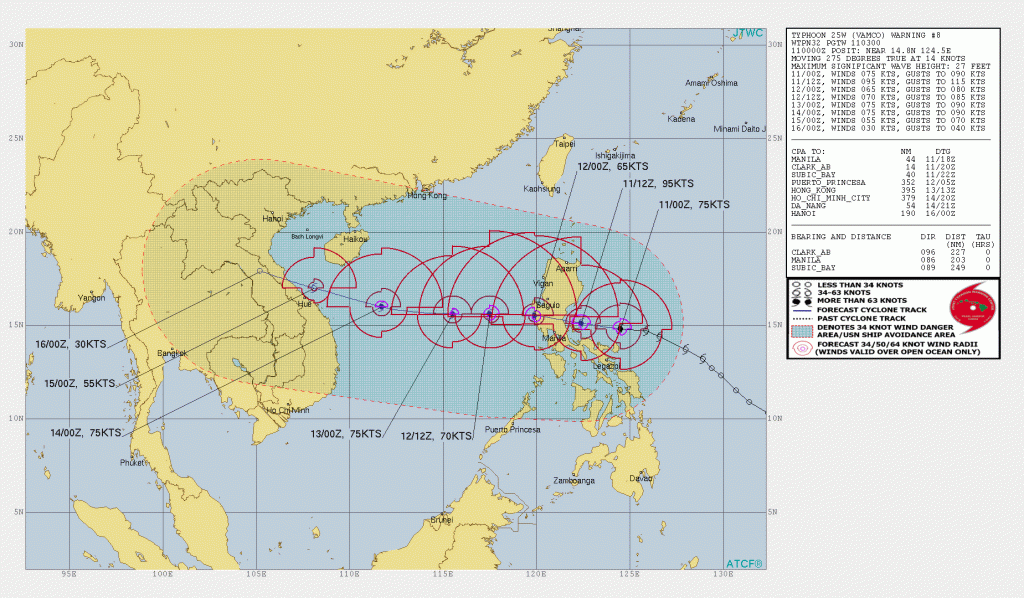
Tropical Storm Vamco has now intensified into a category 1 typhoon, and satellite presentations suggests that the storm is now building up an eye.
Vamco is located near 14.8 degrees north, 124.5 degrees east, approximately 203 nautical miles east of the Philippines’ capital, Manila. The storm has a maximum sustained winds of 85 mph (140 km/h) and a minimum pressure of 982 millibars. The storm is currently moving westward at 14 knots (15 mph) and is expected to continue its rapid intensification right before landfall in Luzon. The Philippines’ local agency, PAGASA, has issued a Signal #3 in parts of eastern Luzon in preparation to the storm.
 Warnings
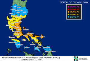
Signal #3, which means winds of greater than 121-170 km/h (75-110mph) may be expected in at least 18 hours, is in effect for:
- The southern portion of Aurora (Dipaculao, Baler, Maria Aurora, San Luis, Dingalan), the southern portion of Nueva Ecija (Bongabon, Gabaldon, General Tinio, Laur, Palayan City, Cabanatuan City, Santa Rosa, Peñaranda, Gapan City, San Leonardo, Jaen, San Antonio, San Isidro, Cabiao), the eastern portion of Pampanga (Candaba, Arayat, Santa Ana, Mexico, San Luis, San Simon, San Fernando City, Santo Tomas, Apalit, Minalin, Bacolor, Santa Rita, Guagua, Macabebe, Masantol, Sasmuan, Lubao), Bulacan, Metro Manila, Cavite, Laguna, Rizal, the northern and central portions of Quezon (General Nakar, Infanta, Real, Mauban, Sampaloc, Lucban, Tayabas City, Sariaya, Candelaria, Dolores, Tiaong, San Antonio, Lucena City, Pagbilao, Atimonan, Padre Burgos, Unisan, Agdangan, Gumaca, Plaridel, Pitogo, Macalelon, Lopez, General Luna, Catanauan, Buenavista, Guinayangan, Tagkawayan, Calauag, Quezon, Alabat, Perez) including Polillo Islands, Catanduanes, Camarines Norte, and the northern portion of Camarines Sur (Del Gallego, Ragay, Lupi, Sipocot, Cabusao, Bombon, Calabanga, Tinambac, Siruma, Goa, Lagonoy, San Jose, Garchitorena, Presentacion, Caramoan).
Signal #2, which means winds of greater than 61-120 km/h (40-75 mph) may be expected in at least 24 hours, is in effect for:
- The central and southern portions of Quirino (Maddela, Cabarroguis, Aglipay, Nagtipunan), the central and southern portions of Nueva Vizcaya (Kasibu, Bambang, Kayapa, Dupax Del Norte, Dupax Del Sur, Aritao, Santa Fe, Alfonso Castaneda), the southern portion of Benguet (Bokod, Itogon, Tublay, La Trinidad, Sablan, Baguio City, Tuba), the southern portion of La Union (Burgos, Naguilian, Bauang, Caba, Aringay, Tubao, Pugo, Santo Tomas, Rosario, Agoo), Pangasinan, Zambales, Bataan, Tarlac, the rest of Pampanga, the rest of Nueva Ecija, the rest of Aurora, Batangas, the rest of Quezon, Marinduque, the northern portion of Occidental Mindoro (Paluan, Abra de Ilog) including Lubang Island, the northern portion of Oriental Mindoro (Pola, Victoria, Naujan, Baco, Calapan City, San Teodoro, Puerto Galera), the rest of Camarines Sur, Albay, Sorsogon, and Burias and Ticao Islands.
Signal #1, which means winds of 30-60 km/h (15-40 mph) may be expected in at least 36 hours, is in effect for:
- Isabela, the rest of Quirino, the rest of Nueva Vizcaya, Kalinga, Mountain Province, Ifugao, the rest of Benguet, Abra, Ilocos Sur, the rest of La Union, the rest of Occidental Mindoro, the rest of Oriental Mindoro, Romblon, and the rest of Masbate,
- Northern Samar, the northern portion of Samar (Santo Nino, Almagro, Tagapul-An, Tarangnan, Calbayog City, Santa Margarita, Gandara, Pagsanghan, San Jorge, San Jose de Buan, Matuguinao), and the northern portion of Eastern Samar (Maslog, Dolores, Oras, San Policarpo, Arteche, Jipapad).
Please prepare immediately from this storm, as it seems that rainfall is gonna be the biggest threat from this storm due to its huge size. Stay updated with your local officials, and evacuate if forced to. Stay tuned for updates.
