Tropical Storm Vongfong becomes the First Storm of the Year in Northwestern Pacific; Likely to Impact the Philippines

Tropical cyclone activity is ramping up in the Northern Hemisphere this week with Tropical Storm Vongfong (known as Tropical Storm Ambo in the Philippines) making an appearance in the Philippine Sea. The cyclone developed rather quickly this morning and currently possesses maximum 1-minute sustained winds of 60 mph (95 km/h). Further intensification is anticipated by both the Japan Meteorological Agency (JMA) and the Joint Typhoon Warning Center (JTWC), and Vongfong will likely reach typhoon status by tomorrow morning. Over on the other side of the Northern Hemisphere, a developing low pressure system could become the North Atlantic’s first tropical or subtropical cyclone of the year later this week or over the weekend. The National Hurricane Center (NHC) is currently monitoring this system with a 70% chance of tropical or subtropical cyclone development within the next five days.
Tropical Storm Vongfong: Forecast Track and Intensity
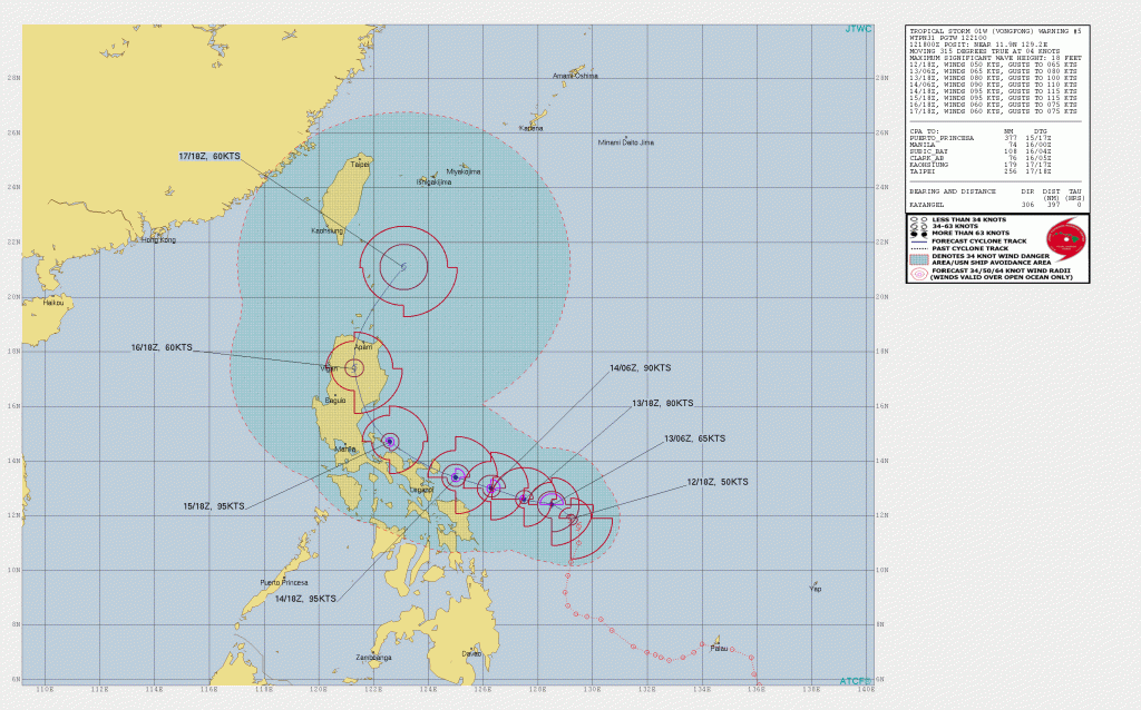
As of 18:00 UTC May 12, Tropical Storm Vongfong is located near 11.9°N, 129.2°E, about 580 mi (935 km) east-southeast of Manila, Philippines. Maximum sustained winds are near 35 mph (55 km/h), gusting to 70 mph (110 km/h), and the minimum central pressure is 998 mb (29.47 inches). The cyclone is moving toward the west-northwest at near 5 mph (8 km/h), and this general motion is expected to continue through Friday, followed by a turn to the north on Saturday, and then to the northeast on Sunday. Environmental conditions are favorable for further development, and Vongfong is expected to reach typhoon strength (1-minute sustained winds of 74 mph (120 km/h) or greater) by tomorrow morning. By Thursday, Vongfong could reach Category 2-equivalent status on the Saffir-Simpson Scale, as reflected by both the JTWC and Force Thirteen’s official forecast.
Impact and Areas at Risk
Vongfong (Ambo) is likely to intensify and impact the Philippines later this week as a potentially potent typhoon. Strong winds, rainfall-induced flooding and landslides, and dangerous storm surge are all possible across much of Luzon through Sunday. Although it is still a bit too soon to definitively determine the magnitude of impact Vongfong may have in the Philippines, residents should take proper precautions ahead of time to ensure that they are well-prepared for the storm’s arrival. The Philippine Atmospheric, Geophysical, and Astronomical Services Administration (PAGASA) has raised the Signal 1 Warning for Eastern and Northern Samar in Visayas. Wind Signal 1 indicates that winds of 30 to 60 km/h and/or intermittent rainfall is expected within the next 36 hours associated with a tropical cyclone. PAGASA recommends that residents in the Signal 1 area take precuationary measures and to continue to monitor the latest severe weather bulletins from PAGASA issued at six-hour intervals.
For more information regarding Tropical Storm Vongfong (Ambo), visit PAGASA on the web at http://bagong.pagasa.dost.gov.ph/, and refer to your local news and government outlets for the latest emergency information. Stay tuned to Force Thirteen’s official outlets at the official Force Thirteen YouTube channel, Twitter, and Facebook pages for future storm updates and the latest information.
