Tropical Storms Erick and Flossie Form in the Eastern Pacific; Both Expected to Become Hurricanes

Within the past two days, two tropical storms have developed in the Eastern North Pacific as the season enters its climatological peak. Tropical Storm Erick formed on July 27 and has been strengthening over the past few days, while Flossie developed as a tropical depression on July 28 and became a tropical storm this morning. Environmental conditions are forecast to be favorable for further development of these cyclones, and both are forecast by the National Hurricane Center (NHC) to intensify into hurricanes. Both tropical cyclones pose a potential threat to the Hawaiian Islands, although it is too soon to determine what, if any, impacts that Erick and Flossie may bring to the islands.
Current Storm Information
Tropical Storm Erick
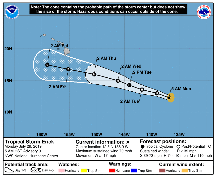
As of 5:00 AM HST (15:00 UTC), the center of Tropical Storm Erick was located near 12.3°N, 136.9°W, about 1310 mi (2110 km) east-southeast of Hilo, Hawaii. Maximum sustained winds were 70 mph (110 km/h), gusting to 85 mph (140 km/h), and the minimum central pressure was 991 mb (29.27 inches). The cyclone was moving toward the west at 17 mph (28 km/h), and a turn to the west-northwest with a decrease in forward speed is expected to occur on Tuesday and into Wednesday. This motion will bring Erick into the Central Pacific Hurricane Center (CPHC)’s area of responsibility soon, which extends from longitude 140°W westward to the International Date Line. Tropical storm-force winds extend outward up to 70 miles (110 km) from the center of Erick. An eye has recently become apparent in microwave imagery, and Erick is expected to become a hurricane very soon. Environmental conditions will be favorable for further intensification of this cyclone, and the NHC forecasts Erick to reach hurricane intensity within the next few hours, and strengthen into a major hurricane by Wednesday. After that time, the cyclone should encounter strong westerly wind shear, which should prompt weakening. By that time, Erick is expected to be moving south of the Hawaiian Islands.
Tropical Storm Flossie
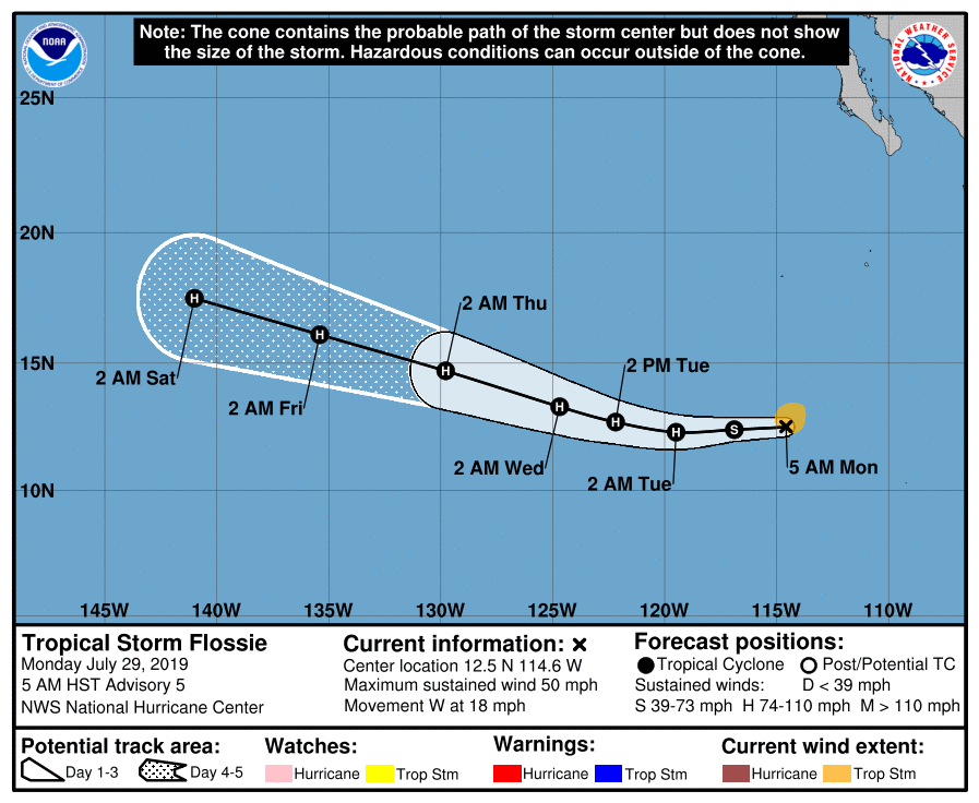
As of 5:00 AM HST (15:00 UTC), the center of Tropical Storm Flossie was located near 12.5°N, 114.6°W, about 820 mi (1315 km) west-southwest of Manzanillo, Mexico, or about 780 mi (1260 km) south-southwest of the southern tip of the Baja California Peninsula. Maximum sustained winds were 50 mph (85 km/h), gusting to 65 mph (100 km/h), and the minimum central pressure was 1002 mb (29.59 inches). The cyclone was moving toward the west at 18 mph (30 km/h), and this general motion is forecast to continue through Tuesday, albeit with some decrease in forward speed. After that time, Flossie is forecast to turn toward the west-northwest and maintain that general motion through Friday. Tropical storm-force winds extend outward up to 80 miles (130 km) from the center of Flossie. Sea surface temperatures ahead of Flossie are warm, and wind shear is low, so further strengthening is anticipated. Flossie is forecast to become a hurricane tomorrow, and gradually strengthen thereafter into a Category 2 hurricane by the end of the week. However, the SHIPS Rapid Intensification index shows a 40% chance of rapid intensification during the next 48 hours, and so Flossie could strengthen faster than shown in the official forecast.
Impact and Areas at Risk
Although it is too soon to determine what, if any, impacts Erick and Flossie could bring to the Hawaiian Islands, now is a good time for residents in the islands to have a hurricane plan in action. While the official forecast track for Tropical Storm Erick shows the cyclone passing south of the islands, the storm’s outer bands could produce brief periods of strong winds, as well as locally heavy rainfall, on the islands. These heavy rains could produce dangerous flash flooding and mud slides. The islands may also see impacts from Tropical Storm Flossie; most of the GFS and ECMWF ensemble members show the cyclone moving close to or over the Hawaiian Islands early next week as a tropical storm. Regardless of whether or not these cyclones directly impact the islands, both are likely to enhance surf and create hazardous sea conditions in the waters near the islands. Residents in the Hawaiian islands should closely monitor the progress of Erick and Flossie.
For more information regarding current activity in the tropics, visit Force Thirteen’s official outlets. Live updates and daily Tropical Weather Bulletins can be found at the official Force Thirteen YouTube channel, and further information can be found on the Force Thirteen Twitter and Facebook pages.
