Tropical Storms Hernan and Iselle form in the Northeastern Pacific; Neither Expected to Significantly Impact Land

While powerful Category 4 Major Hurricane Laura menaces the western U.S Gulf Coast, two new tropical cyclones are stirring up the open waters of the Northeastern Pacific. Their names are Hernan and Iselle, and both developed earlier this morning in quick succession, with Iselle following closely behind Hernan. Hernan and Iselle are the eighth and ninth named storms, respectively, of the 2020 Northeastern Pacific hurricane season, and the fourth and fifth in the month of August. Hernan is located a few hundred miles off the Mexican coast, and is embedded within a broad monsoon gyre that is producing heavy rainfall over portions of southern Mexico and Central America. Iselle is located well offshore, and is not expected to affect land over the next several days.
Tropical Storm Hernan: Current Storm Information
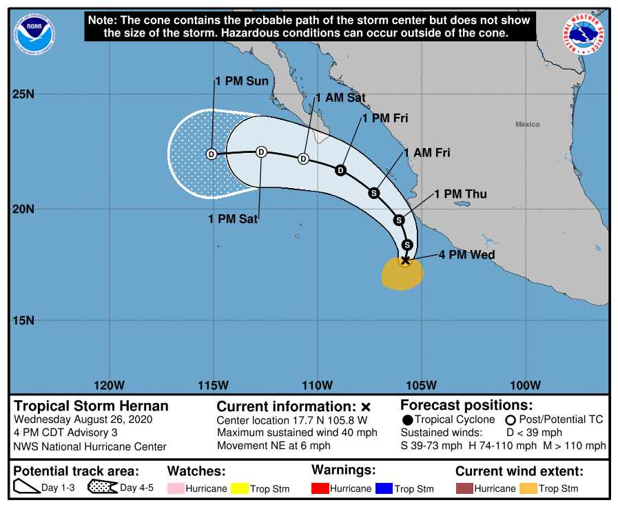
As of the National Hurricane Center’s most recent advisory on Hernan at 4:00 PM CDT (21:00 UTC), the center of Tropical Storm Hernan was located near 17.7°N, 105.8°W, about 185 mi (300 km) south of Cabo Corrientes, Mexico, and about 445 mi (720 km) southeast of the southern tip of the Baja California Peninsula. Maximum sustained winds are near 40 mph (65 km/h) with gusts to 50 mph (85 km/h), the minimum central pressure is 1004 mb (29.65 inches), and tropical storm-force winds extend outward up to 105 miles (165 km) from the center. Hernan is moving toward the northeast at around 6 mph (9 km/h), and a turn to the north is expected tonight, followed by a turn to the northwest on Thursday, and to the west-northwest on Friday. On the NHC’s forecast track, the center and strongest winds and precipitation associated with Hernan is expected to remain just off the southwest coast of Mexico. Little change in strength is forecast during the next 24 hours. Hernan is forecast to weaken to a tropical depression late Thursday, and become a remnant low late Friday. There are no tropical cyclone watches or warnings currently in effect, and Hernan is not expected to threaten land at any point in the next five days.
Tropical Storm Iselle: Current Storm Information
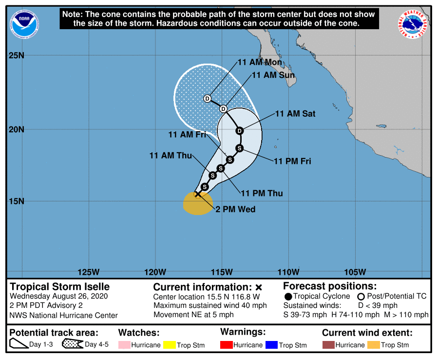
As of the National Hurricane Center’s most recent advisory on Iselle at 4:00 PM CDT (21:00 UTC), the center of Tropical Storm Iselle was located near 15.5°N, 116.8°W, about 680 mi (1095 km) southwest of the southern tip of the Baja California Peninsula. Maximum sustained winds are near 40 mph (65 km/h) with gusts to 50 mph (85 km/h), the minimum central pressure is 1001 mb (29.56 inches), and tropical storm-force winds extend outward up to 105 miles (165 km) from the center. Iselle is moving toward the northeast at around 5 mph (7 km/h), and this general motion is expected to continue through Friday, followed by a turn to the north and then northwest over the weekend. Little change in strength is expected through the next several days. By the weekend, Iselle is forecast to weaken to a tropical depression, and then degenerate into a remnant low shortly afterward. There are no tropical cyclone watches or warnings currently in effect, and Hernan is not expected to threaten land at any point in the next five days.
External Links
For more information regarding Tropical Storms Hernan and Iselle, visit Force Thirteen’s official outlets at the official Force Thirteen YouTube channel, Twitter, and Facebook pages. Force Thirteen is currently running continuous live coverage on Hurricane Laura as it approaches the U.S Gulf Coast at https://www.youtube.com/watch?v=liaqfwJ20zE. You can also view Force Thirteen’s 24/7 cyclone live stream at https://www.youtube.com/watch?v=IJTfMtzpanQ, which includes Hurricane Laura, Tropical Storms Hernan and Iselle, and Typhoon Bavi.
