Two new depressions form in the Atlantic basin

Two new tropical depressions, numbered Thirteen (right) and Fourteen (left) respectively, have formed in the Atlantic basin. Both of these systems are expected to impact land and could intensify into significant hurricanes.
Tropical Depression THIRTEEN
Tropical Depression Thirteen was designated in the Main Development Region of the Atlantic Ocean last night at the 11:00 pm AST advisory. As of 11:00 am AST, Tropical Depression Thirteen has wind speeds of 35 mph and is currently located at around 16.0°N, 52.0°W, moving WNW at about 21 mph.
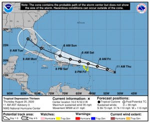
Thirteen is expected to continue moving is a west-northwesterly direction through the next 5 days, however what’s more uncertain is Thirteen’s intensity forecast, which greatly depends on how far north or south Thirteen moves. Generally, if Thirteen moves north and further away from the northern Caribbean Islands, it will become a stronger system, as shown by the HWRF and HMON models. If Thirteen moves more south and towards the northern Caribbean Islands, Thirteen will remain weaker, as shown by the European and GFS models.
Other than potential land interaction, the only factor that may inhibit the development of Thirteen is dry air. Wind shear is likely to remain low and Sea Surface Temperatures are to continue being warm. The National Hurricane Center shows Thirteen gradually intensifying into a hurricane by Day 4, and maintaining minimal hurricane intensity through Day 5, due to uncertainty about how Thirteen will interact with the Greater Antilles.
Tropical Depression FOURTEEN
Tropical Depression Fourteen was designated at 11:00am EDT today. As of 2:00 pm EDT, Tropical Depression Fourteen has wind speeds of 35mph and is currently located at around 15.4°N, 80.0°W, moving W at about 18 mph. A Hurricane Hunter Aircraft is being sent to investigate Fourteen later today.

Fourteen is expected to continue to move west due to the Bermuda High for the next day or so before a trough over the Gulf of Mexico becomes the primary steering current for Fourteen, causing it to slow down while turning towards the northwest and, grazing the Honduran coastline before then beginning to accelerate towards the northwest, tracking over the Yucatan Peninsula this weekend and entering the Gulf of Mexico on Days 4 and 5.
Fourteen is forecast to strengthen little in the next day or so, but to begin strengthening as it begins to turn towards the northwest tomorrow. The forecast from the National Hurricane Center is on the higher end of the models, predicting that low wind shear and Sea Surface Temperatures of 29-30°C will allow Fourteen to strengthen more than major models are showing. The National Hurricane Center has Fourteen as a 70 mph Tropical Storm when it makes landfall on the Yucatan Peninsula on Saturday evening.
***
Regardless of intensity, Tropical Depressions Thirteen and Fourteen are both expected to impact land to some degree. Nearly all of the Western Atlantic should monitor the progress of either one or both of these systems closely over the next few days. The next two names on the Atlantic Naming List this year are Laura and Marco respectively, with the depression that intensifies into a Tropical Storm first receiving the name Laura.
Force Thirteen will continue to monitor the progress of Thirteen and Fourteen here on force-13.com. You can also find us on our YouTube, Twitter, and Facebook.
