Two very intense cyclones prowling in the southern hemisphere, with Niran threatening New Caledonia

The southern hemisphere is currently in a white-hot situation, with cyclones Mirian, 91S, Niran and Habana. In this article, we will focus on cyclone Niran, which now becomes the second category 5 cyclone in 2021, on both Saffir-Simpson Hurricane Wind Scale and the Australian scale. Niran is expected to bear towards New Caledonia and directly brush there, which means New Caledonia is currently under a serious situation, facing a very intense system approach. By the latest Force Thirteen analysis (15:00 UTC, March 5th) it has intensified to 165mph in SSHWS and a pressure of 913mb.
Current Storm Information, Developmental Process, Forecast Track
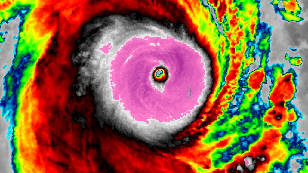
As of 12:00UTC March 5th, by JTWC analysis it is now a category 5 cyclone, located at 18.8S 159.1E with maximum 1-minute sustained winds of 160mph with a minimum central pressure of 917mb. JTWC has a Dvorak fix of Final T number of 7.0, based on Data T number of T7.0 as well.
While at the same time by the analysis from the Bureau of Meteorology, Australia, has it at 18.7S 159.1E, with maximum 10-minute sustained winds of 205km/h with gusts of around 285km/h, which yields Niran a category 5 cyclone in the Australian Scale, as well as a minimum central pressure of 931hPa, moving ESE at 46km/h.
By Force Thirteen operational analysis at 15:00UTC, we have located it at 19.3S 159.8E, with maximum 10-minute sustained winds of 230km/h and 1-minute sustained winds of 165mph (265km/h) and a pressure of 913mb, moving ESE at 28mph (44km/h)
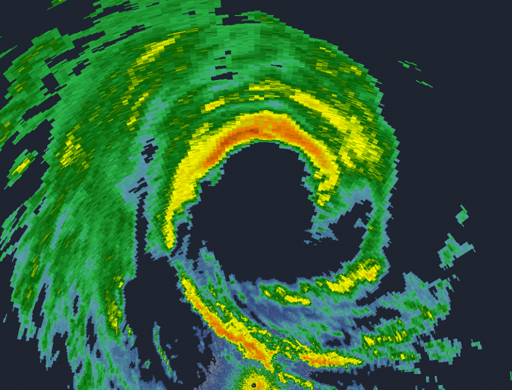
Niran first formed off the coast of Queensland and developed quickly. Arlington and Bougainville Reef, both recorded storm-force winds on March 1st and 2nd respectively, which reflected that it well-developed into a severe tropical storm. Yet due to rather strong easterly wind shear, it turned into a cold cloud cover (CCC) pattern, which indicated that its intensity was held. Then yesterday Niran started a wave of rapid intensification to borderline category 3 system. Willis Island radar successfully captured such a process, which shows an intense north eyewall but broken south eyewall. However, due to easterly shear, the newborn eye in infrared imagery collapsed, ending its first phase of rapid intensification. Throughout early last night, it maintains as a category 2 system. Nevertheless, after struggling, the wind shear near Niran dropped further and it has started its second phase of rapid intensification, with a more compact eye and colder CDO rolling out during the daytime. In satellite imagery, it looks stunning with a smooth symmetric cloud ring with a temperature of -80C and an eye temperature of near 0C. However, this peak is expected to be very short-lived as wind shear will skyrocket due to the jet streak interaction.
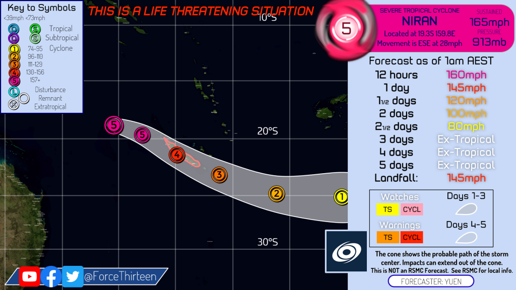
It is expected to peak right now and weaken substantially as it moves towards New Caledonia under a high northwesterly backshear environment, but still, by our forecast, it is prognosticated to strike there as a category 4 system, which is really rare for New Caledonia. Alert number 1 is currently in effect in the entire Caledonia and the level 2 alert, which is the highest level, will be in effect there tomorrow (March 6th) morning, with highly destructive winds, flooding, and landslide as the main threat. To prepare for the storm threat, temporary shelters have been set up to settle the evacuated residents, and it is also recommended to store enough food and good shelters.
After striking New Caledonia it will weaken more rapidly due to lower sea surface temperature and even more wind shear. As it moves into the jet stream two days after, it will also undergo extratropical transition, gradually marking its end of Niran’s journey.
Elsewhere in the tropics, we also have cyclones Marian which is dying off at the open South Indian Ocean, tropical storm 91S which is now passing through Madagascar from west to east as a weak system, as well as cyclone Habana, which has exploded since yesterday, from a tropical storm to category 4 (in SSHWS) cyclone in just 1 day!
Please stay tuned for the latest updates from Force Thirteen and the official agencies, stay safe.

Wow,913 mb?Any upcoming articles on all the February storms?
Yes, by satellite estimates we concluded 165mph and using the CKZ equation to derive the estimated central pressure of 913mb.
For the February cyclones summary, as we are all hands on deck in the US severe weather recently, your request article likely won’t be published shortly. If we have extra hands available we might consider making one, perhaps along with March.
Thanks!
How do yall analyze storms
How do you analyze storms?
Hello Jennifer.
To analyze a storm, in short, we mainly refer to the following techniques:
Infrared: Subjective Dvorak (1984), CIMSS ADT.
Microwave: AMSU, SATCON (which mixes the IR and MW estimates).
If available, surface observations, doppler radial wind, and/or polar satellites wind scans such as SAR, SMAP.