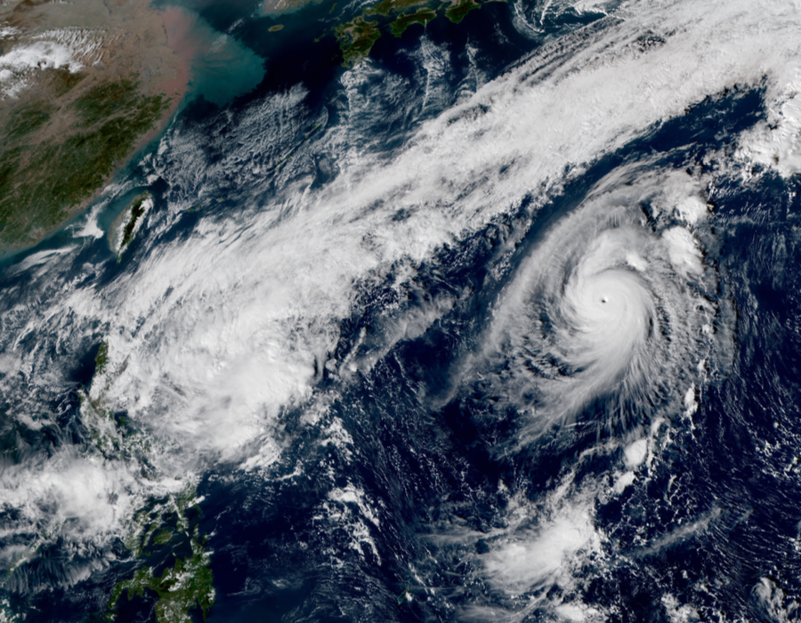
Typhoon Fengshen Rapidly Intensifies; Kalmaegi Threatens the Philippines

The Western North Pacific continues in a period of heightened activity today as Typhoon Fengshen and Tropical Storm Kalmaegi persist over the region. Fengshen has rapidly intensified and is now a Category 3 on the Saffir-Simspon Scale as it churns over the open waters of the Western North Pacific. Kalmaegi remains poorly-organized to the east of the Philippines, but is forecast to strengthen some as it approaches Luzon.
Fengshen Rapidly Intensifies
Tropical Storm Fengshen formed Tuesday over the open Western Pacific Ocean, and after initially struggling to intensify significantly, rapidly strengthened today amid more favorable environmental conditions. As of 12:00 UTC November 15, Typhoon Fengshen is located near 21.1°N, 142.2°E, about 305 mi (490 km) north-northwest of Saipan. Fengshen is moving toward the northwest at 16 mph (26 km/h), and a turn to the northeast and then the east-northeast is forecast during the next two days. Maximum 1-minute sustained winds are near 125 mph (205 km/h), and the minimum barometric pressure is 965 milibars (28.50 inches). There are no tropical cyclone watches or warnings in effect, and Fengshen is not forecast to affect land as it continues over the open waters of the Western North Pacific.
Tropical Storm Kalmaegi a Threat to the Philippines
Over in the Philippine Sea, Tropical Storm Kalmaegi remains poorly-organized as it continues to move slowly westward. The Philippine Atmospheric, Geophysical and Astronomical Services Administration (PAGASA) has assigned the storm the local name Ramon, which it uses in official publications. As of 12:00 UTC November 15, Tropical Storm Kalmaegi (Ramon) is located near 16.8°N, 126.3°E, about 305 mi (490 km) east-northeast of Manila, Philippines. Kalmaegi (Ramon) is nearly stationary, and is forecast to move slowly northwestward during the next two days, moving over the island of Luzon before turning southwestward. Maximum 1-minute sustained winds are near 35 mph (55 km/h), and the minimum barometric pressure is 1000 milibars (29.53 inches). While currently disorganized, Kalmaegi (Ramon) is forecast to strengthen during the next few days, and it could approach typhoon status as it nears the island of Luzon.
Kalmaegi (Ramon) is forecast to bring heavy rainfall to portions of the Philippines, in particular the northern islands. PAGASA has issued a General Flood Advisory for Cagayan and Isabela provinces, and moderate rainfall with possible flooding is forecast in the Cagayan Valley region. Heavy rainfall can produce flash flooding and mudslides, particularly in mountainous and low-lying terrain, and residents in the advisory area should be on alert for possible flooding. Regardless of the exact track and intensity of Kalmaegi (Ramon), residents in the Philippines should closely monitor the progress of this tropical cyclone. For more information, refer to products issued by the Philippine Atmospheric, Geophysical and Astronomical Services Administration (PAGASA) at http://bagong.pagasa.dost.gov.ph/.
