Typhoon Kammuri Close to Landfall, but how Strong Will it be?

Force Thirteen's five-day forecast cone for Kammuri as of 6:00 AM PHT December 1
Luke Katz
Where Will it Go?
Typhoon Kammuri has entered a zone of less wind shear and a more conducive environment during the past 24 hours, which could lead to rapid intensification. The ECMWF and HWRF weather models have been suggesting rapid intensification for the past few days. The only factor against Kammuri right now is how much time is left before it will make landfall in Northern Luzon, possibly close to the capital of the Philippines, Manila. The real question right now is how long it will take to clear out its eye.

There is high confidence in Kammuri’s track, but there are multiple questions with the timing which will decide the storm’s intensity. Right now, the operational intensity of Kammuri by the JMA is 90 mph, but the wind is not the main factor of this system. There is also the risk of life-threatening flooding as well. Force Thirteen’s analysis on the intensity of Kammuri is 110 mph.
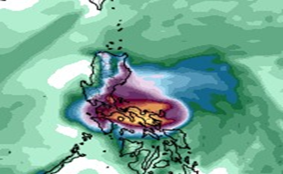
Rainfall Totals for Kammuri
Once Kammuri’s eye clears out, it is full speed for intensification, and Kammuri could be a significant typhoon when it makes landfall. Though the eye has not fully cleared yet, microwave does show a closed eyewall, which indicates that Kammuri’s inner structure is improving.
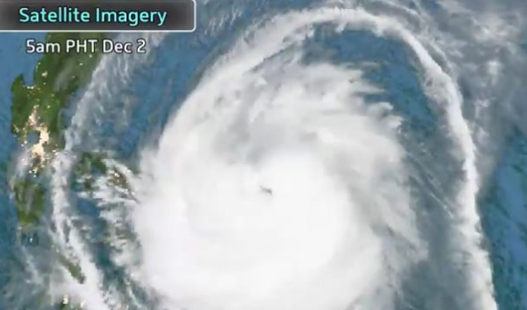
Satellite Imagery
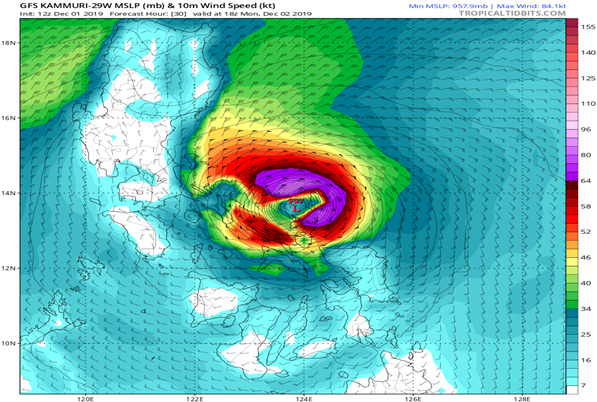
Intensity Guidance
Works Cited
1. www.tropicaltidbits.com “GFS 12z Run, Forecast Hour 42, Western Pacific, 24-Hour Accumulated Precip” https://tropicaltidbits.com/analysis/models/?model=gfs®ion=ea&pkg=apcpn24&runtime=2019120112&fh=42 Accessed 1 Dec. 2019
2. @Force Thirteen “Last three hours of satellite imagery on #TyphoonKammuri #TisoyPH Storm showing signs of intensification before landfall on Monday night. #typhoon” Twitter, 1 Dec. 2019, 1:27 p.m. est., https://twitter.com/ForceThirteen/status/1201251578205917184 Accessed 1 Dec. 2019.
4. www.tropicaltidbits.com “GFS 12z Run, Forecast Hour 30, Typhoon Kammurri, MSLP (mb) and 10m Wind speed (kt.)” https://tropicaltidbits.com/analysis/models/?model=gfs®ion=29W&pkg=mslp_wind&runtime=2019120112&fh=12 Accessed 1 Dec. 2019.
