Typhoon Noru Rapidly Intensifying As It Nears The Philippines

Typhoon Noru (Philippine name Karding) continues to intensify as it nears Luzon, with Signal #3 warnings already in effect for parts of the country.
Current Information
According to Force Thirteen’s 11pm Philippine time (3pm UTC) update, Typhoon Noru (Karding) is currently located at 15.2 degrees north, 125.3 degrees east, with 1-minute sustained winds of 195 kph (120 mph), and a central pressure of 956 millibars. The Philippine Atmospheric, Geophysical and Astronomical Services Administration (PAGASA) estimated Noru to have 10-minute sustained winds of 130 kph (80 mph), with gusts up to 160 kph (100 mph). It is currently moving west-southwest at 23 kph (14 mph).
Current Warnings
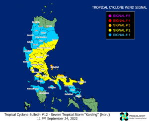
A Signal #3 warning, where winds of 89-117 kph (55-73 mph) are expected within the area in at least 18 hours, is in effect for:
- Polillo Islands and the northern portion of Camarines Norte (Vinzons, Paracale, Jose Panganiban, Capalonga)
A Signal #2 warnings, where winds of 62-88kph (39-55 mph) are expected within the area in at least 24 hours, is in effect for:
- The southern portion of Isabela (Dinapigue, San Guillermo, Echague, San Agustin, Jones),
- Quirino,
- the central and southeastern portion of Nueva Vizcaya (Alfonso Castaneda, Dupax del Sur, Aritao, Santa Fe, Bambang, Dupax del Norte, Kasibu, Quezon, Bayombong, Diadi),
- the eastern portion of Pangasinan (Mangatarem, Basista, Urbiztondo, Malasiqui, Manaoag, Pozorrubio, Sison, Bayambang, Bautista, Alcala, Santo Tomas, Villasis, City of Urdaneta, Laoac, Binalonan, Asingan, Rosales, Santa Maria, Balungao, Umingan, San Quintin, Tayug, Natividad, San Manuel, San Nicolas),
- Bataan, Tarlac, Pampanga, Bulacan, Nueva Ecija, Aurora, Metro Manila, Cavite,
- the eastern portion of Batangas (Talisay, City of Tanauan, Santo Tomas, Malvar),
- Laguna, Rizal,
- the northern and central portions of Quezon (General Nakar, Infanta, Real, Mauban, Calauag, Perez, Alabat, Quezon, Tagkawayan, Guinayangan, Sampaloc, Lucban, City of Tayabas, Lucena City, Pagbilao, Padre Burgos, Atimonan, Agdangan, Unisan, Plaridel, Gumaca, Lopez, Pitogo, Dolores, Candelaria, Sariaya, Tiaong, Macalelon, General Luna, Catanauan, Buenavista),
- the rest of Camarines Norte,
- the northern portion of Camarines Sur (Del Gallego, Ragay, Lupi, Sipocot, Libmanan, Pamplona, Pasacao, San Fernando, Pili, Minalabac, Ocampo, Tigaon, Cabusao, Magarao, Gainza, Canaman, Camaligan, Milaor, Naga City, Bombon, Calabanga, Tinambac, Siruma, Goa, Lagonoy, San Jose, Garchitorena, Presentacion, Caramoan, Sagñay),
- and Catanduanes.
A Signal #1 warning, where winds of 39-61 kph (24-38 mph) may be expected in 36 hours, is in effect for:
- The southern portion of Cagayan (Tuao, Solana, Enrile, Tuguegarao City, Iguig, Peñablanca),
- the rest of Isabela, the rest of Nueva Vizcaya, the southern portion of Apayao (Conner), Kalinga, Abra, Mountain Province, Ifugao, Benguet,
- the southern portion of Ilocos Norte (Nueva Era, Badoc, Pinili, Banna, City of Batac, Currimao, Paoay, Marcos),
- Ilocos Sur, La Union, the rest of Pangasinan, Zambales, the rest of Batangas, the rest of Quezon,
- the northern portion of Occidental Mindoro (Abra de Ilog, Paluan, Mamburao, Santa Cruz) including Lubang Islands,
- the northern portion of Oriental Mindoro (Puerto Galera, San Teodoro, Baco, City of Calapan, Naujan, Victoria, Pola),
- Marinduque, the rest of Camarines Sur, Albay,
- the northern portion of Sorsogon (Donsol, Pilar, Castilla, City of Sorsogon, Prieto Diaz, Gubat, Magallanes, Juban, Casiguran),
- and Burias Island.
Discussion and forecast
Noru is currently exploding. Since shear relaxed last midnight, an overcast has developed and vortical hot towers, one after another has been wraps upshear and consolidating the system. A central dense overcast (CDO) successfully built up during daytime with low-level eye as revealed by multiple microwave passes. Since the afternoon, its appearance has started to rapidly improve as an eye pops out with multiple hot towers rotating and frequently firing up, suggesting a very rapid development, unprecedented rate in models forecast and agencies forecast.
The current intensity from Force Thirteen analyst team is increased to 105kt given that DT5.5 base appearance in Subject Dvorak is persistent in the past 3 hours, with the latest JTWC satellite fix bulletin at 15Z (23:00PHT) suggesting a T5.5 (102kt) as well. Very latest IR frame suggesting a raw DT# is even exceeding 5.8 (base value from CIMSS ADT).
Blending T5.5 (102kt0 and raw ADT 5.8 (110kt) yields our current estimate of 105kts.
The estimated pressure of 956mb derived by Courtney-Knaff-Zehr (CKZ) wind pressure relationship, (ROCI algorithm from Knapp et al. 2013) based on parameters reflected in 12Z HKO weather chart.
Extremely rapid development is expected to continue in the next 12-24hrs. By our estimates an impressive super typhoon strength is expected by nowcasting recent trends. However, we do not rule out the possibility of category 5 strength if eyewall replacement cycle signals does not emerge early.
The storm is expected to landfall in Luzon by tomorrow evening, possibly at super typhoon strength. After landfall, the JTWC forecasts the typhoon to reintensify to a second peak intensity of 165 kph (105 mph), before it makes landfall in Vietnam and weaken shortly thereafter.
Ads by 
Highlighted hazards
Rainstorms, severe storm surge and phenomenal waves (>14m) will cause extreme flooding and landslides. It is an exceptionally concerning situation with unprecedented extreme development close to landfall, which very high alert, preparations and evacuation must be done in a short period of time.
By tonight, moderate to heavy rains is expected over mainland Cagayan and Isabela, and as the storm moves closer, the rains will become heavy and intense with at times torrential over central Luzon, including Metro Manila. Under these conditions, scattered to widespread flooding and rain-induced landslides are expected, especially in areas that are highly or very highly susceptible to these hazard as identified in hazard maps and in localities with significant antecedent rainfall.
Winds will also intensify as the storm moves closer to Luzon, with winds reaching storm-force in strength within any of the areas where Wind Signal #3 is hoisted, while winds may reach gale-force in strength within any of the areas where Signal #2 is hoisted. PAGASA has said that the highest possible wind signal to be hoisted is Signal #4.
The combined effects of storm surge and high waves breaking along the coast may cause inundation or flooding over the coastal areas of Aurora, Quezon (east coast, including Polillo Islands), and Camarines Norte.
Nevertheless, with such extreme winds and underestimation in models forecast, intensive preparation should be conducted URGENTLY. Central Luzon should also be evacuated as soon as possible with landfall expected over there tomorrow evening. Gale winds (63mk/h+) conditions is expected to arrive near tomorrow noon, and hurricane force winds (118km/h) near sunset over Luzon.
Tune in to your local Disaster Risk Reduction and Management Office, and heed evacuation orders as this can be a life-threatening situation. Stay safe from the storm and tune in to us as well as we cover this storm.