Typhoon Vamco continues to intensify; impacts should be felt tonight

Typhoon Vamco continues to intensify despite its closeness to the Philippine landmass, and impacts of the storm should be felt later tonight or tomorrow morning Philippine time.
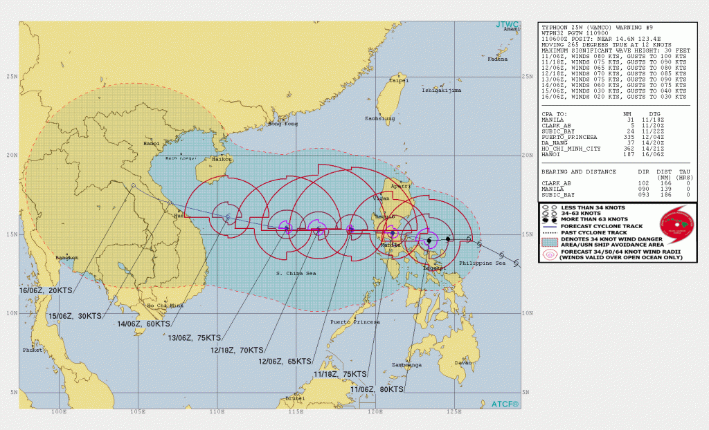
Vamco is located near 14.6 degrees north, 123.4 degrees east, approximately 139 nautical miles east of Manila, Philippines. The storm has a maximum sustained winds of 90 mph (150 km/h), sustained gusts of 115 mph (185 km/h), and a minimum pressure of 975 millibars. The storm is currently going westwards at 12 knots (12 mph) and is a CDPS stage 8 for the country, as it is expected to make landfall at 115 mph (185 km/h) with rainfall as its primary threat, per Force Thirteen’s estimates. The Joint Typhoon Warning Center (JTWC) expects the intensification to continue right before landfall, and is forecasting a peak of 100-105 mph (155-165 km/h) in just under 6 hours.
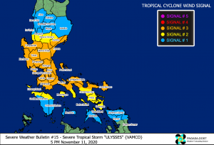 Warnings
Signal #3, which means winds of greater than 121-170 km/h (75-110mph) may be expected in at least 18 hours, is in effect for:
- The southern portion of Quirino (Maddela, Nagtipunan), the southern portion of Nueva Vizcaya (Alfonso Castaneda, Dupax Del Norte, Dupax Del Sur), Pangasinan, Nueva Ecija, Aurora, Tarlac, Zambales, Bataan, Pampanga, Bulacan, Metro Manila, Rizal, Cavite, Laguna, the northern and central portions of Quezon (General Nakar, Infanta, Real, Mauban, Sampaloc, Lucban, Tayabas City, Sariaya, Candelaria, Dolores, Tiaong, San Antonio, Lucena City, Pagbilao, Atimonan, Padre Burgos, Unisan, Agdangan, Gumaca, Plaridel, Pitogo, Macalelon, Lopez, General Luna, Catanauan, Buenavista, Guinayangan, Tagkawayan, Calauag, Quezon, Alabat, Perez) including Polillo Islands, Batangas, Catanduanes, Camarines Norte, and the northern portion of Camarines Sur (Del Gallego, Ragay, Lupi, Sipocot, Cabusao, Bombon, Calabanga, Tinambac, Siruma, Goa, Lagonoy, San Jose, Garchitorena, Presentacion, Caramoan).
Signal #2, which means winds of greater than 61-120 km/h (40-75 mph) may be expected in at least 24 hours, is in effect for:
- The rest of Quirino, the rest of Nueva Vizcaya, the southern portion of Benguet (Bokod, Itogon, Tublay, La Trinidad, Sablan, Baguio City, Tuba), the southern portion of La Union (Burgos, Naguilian, Bauang, Caba, Aringay, Tubao, Pugo, Santo Tomas, Rosario, Agoo), the rest of Quezon, Marinduque, the northern portion of Occidental Mindoro (Paluan, Abra de Ilog) including Lubang Island, the northern portion of Oriental Mindoro (Pola, Victoria, Naujan, Baco, Calapan City, San Teodoro, Puerto Galera), the rest of Camarines Sur, Albay, Sorsogon, and Burias and Ticao Islands.
Signal #1, which means winds of 30-60 km/h (15-40 mph) may be expected in at least 36 hours, is in effect for:
- Isabela, Kalinga, Mountain Province, Ifugao, the rest of Benguet, Abra, Ilocos Sur, the rest of La Union, the rest of Occidental Mindoro, the rest of Oriental Mindoro, Romblon, and the rest of Masbate,
- Northern Samar, the northern portion of Samar (Santo Nino, Almagro, Tagapul-An, Tarangnan, Calbayog City, Santa Margarita, Gandara, Pagsanghan, San Jorge, San Jose de Buan, Matuguinao), and the northern portion of Eastern Samar (Maslog, Dolores, Oras, San Policarpo, Arteche, Jipapad).
Please prepare immediately from this storm as rainfall totals have even reached as high as 200 mm in other areas. Please evacuate if forced to, and keep updated with your local agencies. Stay tune for updates.
