US Severe Weather Scene Heats Up Entering May

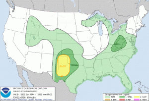
The US severe weather scene has become busy once again, with potential major severe weather events on tap– one in the Great Plains this afternoon until tomorrow and a continuing threat to the Midwest on Saturday, and a threat to the South on Sunday. The Storm Prediction Center has issued a Moderate Risk (Level 4/5) for areas of Nebraska and Kansas, with the possibility of strong tornadoes. The convection will move east overnight, however as previously mentioned, the system will provide continuing chances for severe weather.
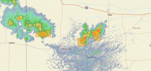
Late into the afternoon into the early evening, the activity will peak near the south-central Nebraska / north-central Kansas border. All severe weather hazards are possible, but wind would post the greatest risk of significant damage at 45%, hail at 30%, and tornadoes at 15%. The formation of supercells is possible across central Kansas towards north-central Oklahoma. If the supercells form, very large hail along with tornadoes will be the primary hazards. This activity should tend to weaken overnight as instability diminishes over the Ozark Plateau. If activity stays clustered, damaging winds would be the greatest threat, although tornadoes would still be possible
On Saturday, the activity will move eastward towards southwestern Wisconsin, eastern Illinois, and western Indiana. Heavy rains associated with the severe thunderstorms are likely to extend to northeastern Arkansas and northwestern Tennessee. Saturday’s main threat sees the potential for large hail, damaging winds and a few tornadoes primarily in Southern Wisconsin and Illinois. A slight risk of severe weather is currently in place.
By Sunday, another disturbance will develop in the South that will mostly cover northwestern Texas and western Oklahoma, including the panhandle. Severe Thunderstorm activities are forecast to start by Sunday afternoon along the eastern New Mexico – northwestern Texas border. The thunderstorms are expected to become more organized in the late Sunday afternoon into early evening as the activity moves east. Large hail as large as 2 inches are possible in northwestern Texas into the Oklahoman panhandle. Tornadic supercells could form over northwestern Texas, which could produce a strong tornado or two. Wind damage could be considerable in northwestern Texas and western Oklahoma, including the panhandle. Activity would likely continue on Monday over northeastern Texas and eastern Oklahoma.
Force Thirteen US will be live covering the threat posed by the storms all week, you can watch our coverage using the link below!
Watch Here: https://www.youtube.com/watch?v=3g9fh0sQlKw

this resulted in another andover tornado