When Will the Atlantic Start Seeing Activity?

Ever since Andrea’s brief existence during the latter half of May and 91L’s tease at formation at the start of June, the Atlantic has been rather quiet. While this is typical, as June is normally a very quiet month, there has been a marked lack in any disturbances within the past several weeks. This also extended into the Pacific as well, although the formations of Alvin and Sepat this week have ended that stretch. To some, it may seem like the forecasts for a busy season could have been a bust. But don’t let the quiet start take your guard down.
Over the past several weeks, there has been large-scale subsidence across most of the Atlantic and Eastern Pacific that has prevented the development of convection, as subsiding air cools and dries out. This has been the result of a convectively decoupled phase of the Madden-Julian Oscillation (MJO) remaining over the basin for the majority of the month, promoting less convective activity. When convective activity is suppressed, then the pressures are allowed to rise. High wind shear from upper-level troughs across the basin has also not been allowing for thunderstorms to persist and bundle, which is a key ingredient for a disturbance to have a chance of development. In addition, Saharan dust embedded within the Saharan Air Layer (SAL) has been dominating most of the tropics recently, although this is quite typical during the early part of the summer. All of these factors combined have not allowed for disturbances to flourish and develop into tropical cyclones. however, this will likely soon change.

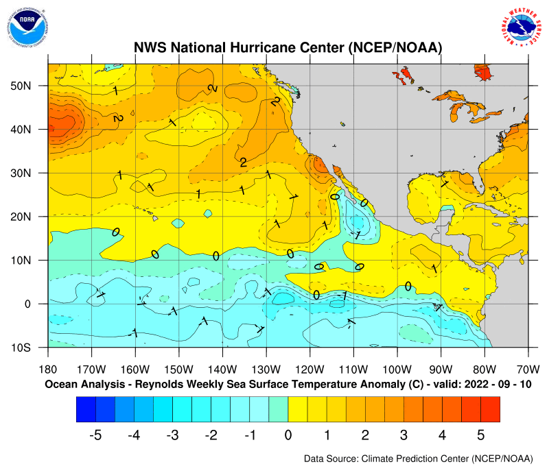
Right now, the El Nino has been weakening substantially due to the persistence of easterly wind bursts and the lack of warm ocean anomalies in the subsurface. Rather, cooler anomalies have been upwelled due to the lack of westerly wind bursts to force the warmer anomalies eastward across the equatorial Pacific. The Pacific Decadal Oscillation (PDO) signature to the north is also fragmented, as there exists a region of cooler anomalies off the West Coast of the U.S., which is not allowing for the classic +ENSO signature. As a result, the anomalies within the ENSO 3.4 region are dropping and the highest SSTAs are currently located in the equatorial Central Pacific, west of the typical Nino regions. This could be allowing for the formation of a Modoki El Nino, but as of now, it will likely be very weak, possibly not going above the typical threshold for an El Nino (+0.5 SSTA). It appears likely that this pattern may persist into the remainder of the summer and into the heart of the hurricane season.
As for the Atlantic itself, the configuration is not quite ideal at the moment, as the Atlantic Multidecadal Oscillation (AMO) signature does not concentrate the warmest anomalies within the tropical Atlantic, but rather farther north into the subtropics, especially closer to North America where ridging is stronger. The waters in the tropical Atlantic and south of western Africa are cooler than average at the moment, but a lot of those lower anomalies are due to increased heat energy input into the West African Monsoon, which is stronger than average this year. Cooler anomalies are also focused near and east of Maritime Canada as a result of a higher abundance of non-tropical storm activity. However, the warm anomalies are not as far north as it once was and has been progressively pushing southward with time. This is a typical phase of a 2nd EOF AMO, where the warmest anomalies are centered between the tropical and the polar waters. The somewhat neutral but slightly negative North Atlantic Oscillation (NAO) pattern is allowing only slight movement of the warm anomalies southward. However, the NAO is expected to become progressively more negative as a result of less ridging over the subtropical eastern Atlantic. According to climate models and past analog years, these warm anomalies will be centered over the tropical Atlantic, which will likely prove more favorable for a busier hurricane season, as tropical waves should develop more frequently in the deep tropics. This would set up the basin into a 1st EOF AMO, which is the most optimal setup for an active hurricane season. It will be difficult to determine how this will hold as the peak of the hurricane season approaches, but it will likely bode well for yet another above average year.
Climate models are taking all of these factors into account and forecasting lowering shear and increased precipitation across the tropics, but not until the second half of July, which is also when the MJO comes back into a favorable configuration for tropical development across the basin. As a result, activity will likely remain quiet until the middle to end of July, when we may finally start seeing activity ramp up. This will also more than likely begin at the end of the train of storms forecast by some of the models in the EPAC basin within the next few weeks, of which Alvin may just be the start of. Nevertheless, always have a hurricane plan ready just in case a storm comes knocking on your door later this season.


