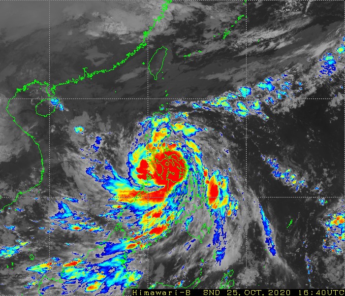
While Saudel is meeting its end, Molave rapidly intensified and smash the Philippines. Vietnam will be its next target.

Surprise surprise, Molave intensified rapidly from tropical storm to typhoon just 18 hours after naming. Its CDO rolled quickly and forming an eye, apparently shown in visible and radar imagery. The central part of the Philippines is suffering from typhoon force winds and torrential rain, threatening people’s lives there. Large swaths of Bicol region is now out of power with transmission lines being broken, severe flooding is reported over many places in central Philippines, and the impact is still spreading. After brushing the Philippines, it will re-intensify to a higher intensity and yet again, approaching Vietnam, imposing even bigger threat since Saudel, which now has weakened to a mere tropical storm, and is going to make landfall over Hà Tĩnh Province, Vietnam soon.
Current Storm Information (Typhoon Molave 21W [PH: Quinta])

As of 23:00PHST (15:00UTC), according to JMA’s advisory, Molave is located at 13.3N 122.3E, with 10-minute maximum sustain winds of 35m/s, with minimum central pressure of 980hPa, same as that of 20:00, and moving west at 35km/h. However, again, ground observation has proved a higher intensity, with Virac bottomed out at 978.4hPa mean sea level pressure (MSLP) at 17:00, around 20km away from Molave’s center, which supports a 970-975hPa peak. PAGASA latest 23:00 analysis in severe weather bulletin yields Molave at 13.3N 122.8E with 10-minute sustain of 125km/h 10-minute sustain wind strength and gust of 150km/h, while HKO 20:00 put it at 120km/h, 970hPa, in which they are more accurate. Molave has made 3 landfalls on the Philippines, the first one was made at 18:10 on San Miguel Island, Albay, second one at 18:50 on Malinao, Albay and the third one over San Andres, Quezon at 22:30, and more landfalls will still occur in the next few hours.
Current Warnings in affect

Signal 3: Most part of Southern Luzon and Mindoro region
Signal 2, extreme northern edge of Visayas, remaining part of southern Luzon and Mindoro, southern part of Central Luzon
Signal 1, remaining part of central Luzon, southern edge of southern Luzon, northern part of Visayas region down to northern Samar, northern Palawan Islands and northern Panay Island.
Forecast Track, Intensity and Areas of Impact
After brushing the Philippines, it’s expected to continue its ~25km/h west or west-northwest movement, and intensify further in central portion of South China Sea to an upper-end typhoon or even severe typhoon on Tuesday or Wednesday, predicted by various agencies in the Western Pacific, then weaken a bit possibly due to cooler sea surface temperature near the western edge of South China Sea. Yet still, it will impose significant threat to Vietnam again, bringing typhoon force winds and even heavier rainfall, and likely, becoming the strongest landfalling storm over Vietnam this year up to this October. The central Vietnam flooding occurred earlier this month due to southwest monsoon brought from the Bay of Bengal that caused persistence rainfall, as well as 4 tropical cyclones (Linfa, Nangka, “Ofel” (PH name) and Saudel bearing on there before Molave as well. With Molave also approaching, this further worsen the flooding hazard in central Vietnam and this should gain more attention.
Current Storm Information (Tropical Storm Saudel 19W [PH: Pepito])

As of 22:00 Indochina standard time, (15:00UTC), according to JMA’s advisory, Saudel is located at 17.6N 107.6E, with max 10-minute sustain winds of 18m/s and a pressure of 1002hPa, moving west with 15km/h speed. It will make landfall on Hà Tĩnh Province early next morning and dissipate over Laos. On Con Co Island, Vietnam F6 winds and F8 gust in Beaufort scale are recorded, and from Nghe An to Thua Thien Hue provinces, 30-80mm rainfall is nowcasted and this amount is expected to remain around the same in the next 24 hours. Level 3 warning of natural disaster risk is still in affect in Vietnam.
