Winter Storm Complex Spawns Tornadoes Across South, Drops Swath of Snow on Midwest and Northeast
March 3rd brought wind, rain, snow, and severe weather to much of the eastern half of the United States. From feet of snow to destructive tornadoes, this one system had it all.

MASSACHUSETTS — A large, fast moving winter storm complex caused serious issues across much of the eastern half of the United States on Sunday through Monday morning, before moving into Atlantic Canada by midday, March 4th.
The winter storm, unofficially named “Scott” by The Weather Channel, began as a rather harmless low over the Western United States on Saturday. It dropped several inches of snow over the Rockies before rapidly moving into the Midwest by Sunday morning.
The storm continued to quickly move eastward over the Midwest, and due to its fast movement little snowfall was recorded, with most locations picking up just a few inches of snow.
However, the situation in the Southeast began to rapidly deteriorate during the afternoon hours on Sunday, when the southern fringe of the storm quickly began developing strong thunderstorms over Alabama and Georgia.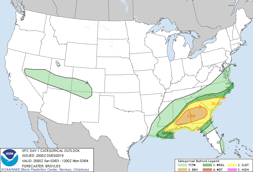
SPC Outlook from 2000 UTC (2 PM CST, 3 PM EST), mere hours before multiple deadly tornadoes struck Alabama and Georgia.
Over the following hours, multiple large tornadoes wrecked havoc over the Southeast. The most serious of the day, the Lee County Tornado, carved out a path over 25 miles long through eastern Alabama before moving into Georgia and weakening. The tornado, which is currently still under investigation, was rated an EF4 by NWS Birmingham on Monday afternoon, becoming the first EF4+ rated tornado since the Canton, Texas tornado on April 29, 2017. Hundreds of homes were damaged or destroyed, and at the time of writing, 23 deaths have been confirmed as a result of this tornado.
BREAKING: Preliminary EF-4 Tornado Damage has been found along County Road 39 just east of Cave Mill Road in southwestern Lee County. Winds have been estimated at 170mph. Single family homes were completely destroyed. Photos are from those survey locations.
#alwx pic.twitter.com/euYNfSDY11— NWS Birmingham (@NWSBirmingham) March 4, 2019
The powerful EF4 passed just north of central Smiths Station, destroying a cell tower and sending a billboard sign flying over 20 miles away. 
The mangled cell tower left behind by the Lee County EF4. The tornado crossed directly over U.S Highway 280 outside of Smith’s Station. Image courtesy of Mike Haskey.
At the end of that day, a total of 41 tornadoes were reported across Alabama, Georgia, Florida, and South Carolina. Surveyors from the National Weather Service will continue to investigate all tornado reports. Lee County schools are closed on Monday and Tuesday after the deaths of 3 schoolchildren. An elementary school in Smiths Station sustained damage from the tornado, and saw its roof torn off. It is currently unknown how long it will take to repair the building and when affected children will be going back to school.

The winter storm, however, was not done yet. Severe weather in the Southeast concluded by 9 PM local time as the weather system raced up the Eastern Seaboard and brought heavy snow to much of the Northeast. For many, this was the biggest snowfall of the entire winter, particularly along the I-95 corridor. The heaviest snowfall fell in southeastern New England, with Milford, Massachusetts picking up over 17 inches of snowfall. The storm overperformed significantly across the region, with forecast errors of up to 5 inches in certain locations. 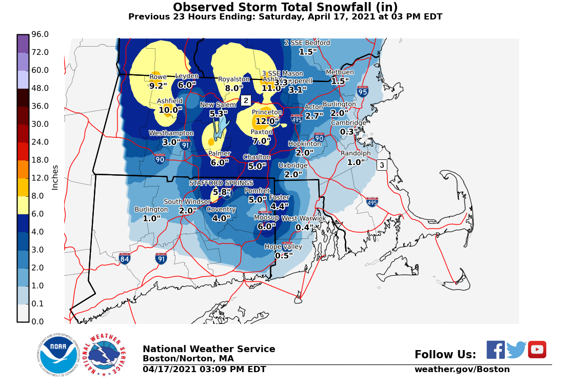
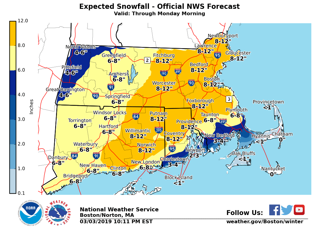
Last NWS Boston forecast prior to the beginning of the storm (right), compared to the Storm Total Snowfall after the storm (left). Significant forecast errors occurred in northeastern Connecticut and eastern Massachusetts, where snowfall amounts greatly exceeded expectations.
Heavy snowfall rates approaching 1 inch/hr+ were observed for several hours past midnight, likely resulting in the higher-than-expected snow totals. Snow concluded across much of the region by 10 am EST as the low moved away into Atlantic Canada. Schools across the region were closed Monday for the largest snowfall of the winter, with Boston picking up over a foot of snow and doubling it’s winter total to date. However, this may very well be the last big snowstorm for coastal New England as a warmer pattern is set to take a firm hold by mid-March.
The low brought in a brief return of warmer temperatures before they once again dip down below freezing by Monday night for what may be the last hurrah for the 2018-19 winter.
