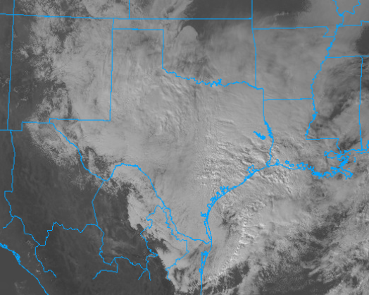
Winter Storm Expected to Sweep Across Texas and into Mississippi Bringing Heavy Snow and Rain

A rare winter storm is currently making its way across Texas today and will move into Louisiana and Mississippi tonight and into tomorrow. This storm will bring mainly snow to this region but freezing rain and sleet can not be ruled out in Southern Louisiana and Mississippi and heavy rain in Southern Texas will also be possible. The Weather Prediction Center (WPC) has stated that on the WSSI, this storm is expected to bring extreme impacts to two large areas in Texas meaning extreme disruptions of daily life and property damage is likely. Everyone ahead of this storm needs to be prepared for it as it will be severe when it comes.
Current Information and Forecast
The storm is currently situated over Western Texas where the low pressure is with heavy precipitation falling across Eastern Texas from the southern Oklahoma border south to the Texas coast. The snow will taper off by the afternoon in Western Texas as the bulk of it will move into Northeastern Texas where. This will be picked up by a developing low pressure system near the Texas-Mexico border that through the day will move northeast across the Gulf. This will pull the snow eastward and by around 7-8pm CST it will become more widespread over Louisiana. A wintery mix will also be possible over Central Louisiana and on the southern side of the state, the precipitation will be mostly rain. By the morning hours of Monday the storm will continue to move east and snow will be possible over Northern Mississippi and Alabama though by this point it will be lighter and mostly rain thanks to warming temperatures. Winter Storm Warnings are in effect for Central Texas into Northern Louisiana and Western Mississippi with Winter Weather Advisory’s in effect around this region as well as Southern Arkansas and Western Alabama.
Impacts
Significant impacts are likely from this storm but will mainly be in the form of snow. The heaviest snow will fall over west-central Texas around the Abilene region. Here 8-11″ of snow can fall which will cause significant accumulations and driving difficulties. However, the winds will be relatively light at 5-10mph meaning blowing snow and drifting will be minimal. The storm will move South of the Dallas/Ft Worth area and bring the heaviest snow south of the city where accumulation up to 8″ are possible. the rest of the region will se snow totals of generally less than 4″. As the storm moves East, the heaviest totals will be in an area from Tyler, TX to Monroe, LA west toward Lufkin, TX where 2-4″ of snow are possible. South of this region, snow totals and sleet totals of up to 2″ will be possible with a light glaze of ice also possible in some regions. In Mississippi, the heaviest snow accumulations of 2-4″ will occur on the Eastern part of the state while the rest will generally get about 2″ and some areas may get a glaze of ice as well.
Heavy rain will also be a problem to areas along the coast. In Southern Texas about 0.5-1″ can fall which could lead to some minor flooding in areas prominent to this. In Louisiana, rain will generally accumulate to about 0.5-0.75″ but some areas near the mouth of the Mississippi River could receive up to an inch. minor flooding is possible and a brief thunderstorm cannot be ruled out but most areas will be safe from flooding.
Be prepared for when this storm comes as significant impacts are likely. Listen to local forecasters and The National Weather Service for official information. The Force Thirteen US channel has published an update on their YouTube channel about this system and more updates will be posted on Twitter. Be Ready for when it comes and most importantly, be safe.
