Winter Storm Warnings Issued in Southern Rockies and the Plains Ahead of Potentially Historic Snowstorm

After a cold and wintry February, much of the United States has enjoyed a couple weeks of warmth and dry weather. As they say, good things aren’t meant to last forever, in this case referring to a storm forecast to move through the Rocky Mountains and Eastern Plains this weekend.

Snowfall in Colorado is forecast to begin primarily over higher elevations of the Rocky Mountains today before spreading into the front range, Denver-metro area and Eastern Plains tonight into tomorrow morning. This snowfall will become heavy and will likely last as such throughout the weekend. Lighter snowfall will linger throughout Sunday night and Monday morning. Some forecasts for those further northeast in Colorado, especially those at lower elevation, are prone to uncertainty regarding total snowfall and the time at which rainfall will transition to snow.
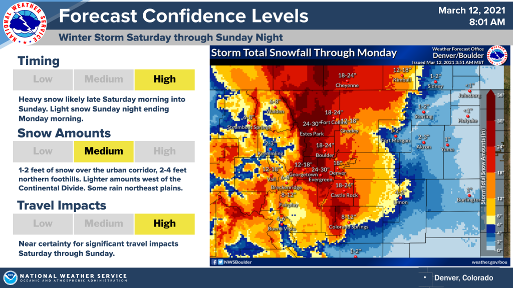
The heaviest snow will likely be experienced over the front range and northern foothills, with between 2-4 feet forecast. The urban corridor is predicted to still receive a lesser but equally catastrophic 1-2 feet. Forecast amounts become increasingly light as you progress further East, with notable uncertainty regarding totals east of points such as Limon and Fort Morgan as stated before. Certainty of significant snowfall closer to the front range, foothills and the metro is high, however. Commute impacts will near certainly be extreme, with any sort of travel likely to be “near impossible” throughout the weekend.
Forecasted Amounts by City through Monday
- Estes Park – 24-30″
- Boulder – 18-24″
- Castle Rock – 18-24″
- Fort Collins – 18-24″
- Cheyenne – 18-24″
- Denver – 18″
- Greeley – 12-18″
- Vail – 12-18″
- Steamboat Springs – 6-8″
- Limon – 4-6″
- Fort Morgan – 1-2″
For further information, refer to your local meteorological office. Force Thirteen is also providing further updates in addition to live coverage on storms around the world through their facebook, twitter and youtube platforms.
