Yasa ramped up quickly after stalling, significant impact to Fiji is likely. Meanwhile Zazu is turning southeastward fighting against shear.

In the past two days Yasa barely moves, but due to this, it absorbed so much energy and with good outflow, it has started to intensify more rapidly. Currently it is a category 5 cyclone in Australian scale and category 4 in SSHS. It is expected to continue its intensification and may deal extreme impact to Fiji as a very intense cyclone. Those in Fiji should start taking procedures of preparation of a tropical cyclone seriously.
Current Storm Information (Yasa)
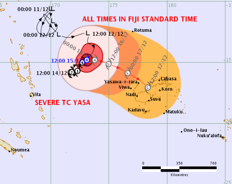
As of 06:00FJT December 16th, per JTWC, Yasa was located at 14.8S 173.8E, with maximum 1-minute sustain winds of 135kts (250km/h) and a minimum central pressure of 919mb.
At the same time, the Fiji Meteorological Service (FMS) estimated Yasa was at 14.4S 173.3E and maximum 10-minute sustain winds of 120kts (220km/h) as well and a pressure of 917mb.
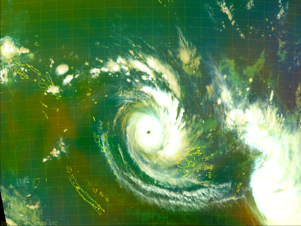
The eye of Yasa is still warming up and has cleared out after convection blobs wrapping around. Currently the eye temperature has exceeded +10C with a diameter of ~40km, in conjunction with a circular, smoother CDO with cloud ring of over -70C wrapping around it, signaling that it is intense and still have space to ramp up, and is very likely to shoot to category 5. JTWC is forecasting 175mph (280km/h) peak in their latest advisory. If Yasa really makes to category 5 status, it will become the earliest category 5 in a South Pacific season, surpassing Zoe in 2002, in which it made it on December 27th.
Forecast Discussion (Yasa)
The forecast track is now more certain in terms of its track and intensity, unlike few days ago when there is huge uncertainty due to interaction between Yasa and 04P. Now it’s expected to move northeast slowly at 2mph, then dive southeastward like a parabola, and accelerate and 3 days later, it’s expected to make landfall on Fiji as a category 4 cyclone (category 5 in Australian Scale), bringing possible of over 250km/h winds, which such speed is very catastrophic.
Current Storm Information and Forecast (Zazu)
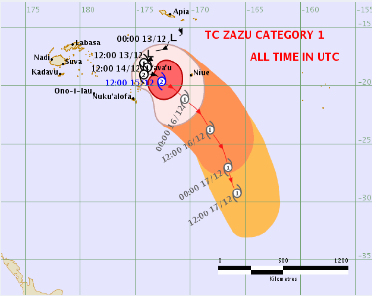
As of 06:00FJT per JTWC Zazu was located at 19.8S 171.3W, with maximum 1-minute sustain winds of 55kts (105km/h) and a pressure of 986mb.
At the same time, FMS has Zazu located at 19.6S 172.1W with max 10-minute sustain winds of 50kts (95km/h) and a pressure of 980mb.
Currently Zazu is being sheared to southeast by the strong outflow of Yasa. Notwithstanding, it defends hard and successfully build a core with -80s cloud tops. What’s more, a microwave eye also popped out recently.
Zazu is moving southeast at 18km/h, and accelerates. In the next day or two, it may bring strong winds and showers to Niue and Tonga.
Please pay attention to the officials instructions and the latest updates. This is a life-threatening situation especially for Yasa.
