Typhoon Noru leaves trail of destruction as it leaves Philippines, sets eyes on Vietnam

Typhoon Noru (Philippine name Karding) is leaving Luzon after its landfall yesterday night Philippine time, which caused massive flooding and the death of five rescuers, and is being forecast to hit Vietnam as a strong typhoon in the coming days.
Current Information
As of the Japan Meteorological Agency’s 6am UTC update, Typhoon Noru is currently located at 15.9 degrees north, 116.9 degrees east, with 10-minute sustained winds of 120 kph (75 mph), with gusts up to 175 kph (110 mph), and a central pressure of 980 millibars. The Joint Typhoon Warning Center (JTWC) estimated Noru to have 1-minute sustained winds of 150 kph (90 mph), with gusts up to 185 kph (115 mph). It is currently moving west at 26 kph (16 mph).
Current Warnings
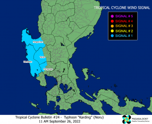
A Signal #1 warning, where winds of 39-61 kph (24-38 mph) may be expected in 36 hours, is in effect for:
- The central and western portions of Pangasinan (Santa Barbara, Bayambang, Mangaldan, Dagupan City, Calasiao, San Carlos City, Basista, Urbiztondo, Mangatarem, Aguilar, Bugallon, Binmaley, Lingayen, Labrador, Sual, City of Alaminos, Bolinao, Anda, Bani, Agno, Burgos, Mabini, Dasol, Infanta, Malasiqui, Alcala, Bautista), Zambales,
- the western portion of Tarlac (Camiling, San Clemente, Santa Ignacia, San Jose, Mayantoc, Capas, Bamban),
- and the northwestern portion of Pampanga (Mabalacat City, Angeles City, Porac, Floridablanca).
A Yellow Typhoon Warning is in effect for:
- The entirety of Hainan Province, China.
A Blue Typhoon Warning is in effect for:
- The southwestern portion of Guangdong (Xuwen County, Suixi County, Yangxi County, Leizhou City, Lianjiang City, Maoming City, Wuchuan City, Taishan City).
Warnings have been put out in Vietnam, with the provinces of Quảng Nam, Quảng Ngãi, Bình Định, and the city of Da Nang being put into disaster risk level 4, while the provinces of Quảng Trị, Thừa Thiên Huế, Phú Yên, Gia Lai, and the city of Kon Tum have been put into disaster risk level 3.
Current Forecast
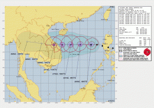
According to the 9am UTC JTWC update, Noru is set to continue intensifying under an environment of low wind shear, high sea surface temperatures, and strong radial outflow, and peak as a strong Category 3 typhoon in the Saffir-Simpson scale, with 1-minute sustained winds of 205 kph (125 mph). The storm will then hit south of the city of Huế by the same intensity on Wednesday early morning, and dissipate by Friday.
Ads by 
Current Hazards
According to Vietnam’s National Centre for Hydro-Meteorological Forecasting (NCHMF), strong winds, heavy rains, and storm surge are the primary threat for the storm.
From tomorrow morning, the coastal areas from Quang Binh to Ninh Thuan (including the island districts of Con Co, Cu Lao Cham and Ly Son) are forecast to experience strong winds and high waves of 8-10 m (26-33 ft) in the morning, and by the night, the coastal waters of the area from Thua Thien Hue to Binh Dinh will have sea waves of 3-5 m (10-16 ft) high, with higher values near the storm’s center. The area from Quang Binh to Quang Ngai needs to beware of storm surges with a height of 1.0-1.5 m (3-5 ft), causing flooding in low-lying and low-lying areas along the coast and estuaries. All ships, aquaculture areas and activities in the above seas are at high risk of being affected by strong winds, high waves, cyclones and storm surge.
As the storm moves in to Vietnam tomorrow, the coastal areas of Thừa Thiên Huế, Da Nang, Quảng Nam, Quảng Ngãi, Bình Định are forecast to get storm-force winds of 76-103 kph (41-55 mph), with areas near the center experiencing typhoon-force winds of 118-149 kph (64-80 mph) and gusts up to 183 kph (99 mph); areas deeper inland will have gale-force winds of 63-87 kph (34-47 mph), with gusts reaching 149 kph (80 mph). The city of Kon Tum and the province of Gia Lai, by Wednesday, will feel winds of 40-50 kph (22-27 mph), and gradually increasing to 51-75 kph (28-40 mph), with other areas having winds up to 87 kph (47 mph) and 117 kph (63 mph).
From tomorrow to Wednesday, the areas of Quang Tri, Thua Thien Hue, Da Nang, Quang Nam, Quang Ngai and Kon Tum are forecast to have very heavy rain with a common rainfall amount of 250-350mm (10-14 in)/period, in some places over 400mm (16 in)/batch; Quang Binh, Binh Dinh and Gia Lai areas are forecast to have heavy to very heavy rains with a common rainfall amount of 100-200mm (4-8 in)/time, with over 300mm (12 in)/time in some places. The North Central region of Vietnam and the South of the Northern Delta is forecast to experience the heavy rains by Wednesday.
Stay safe from this storm, and always consult your local officials for up to date information. Stay tuned to us here at Force Thirteen, as we continue to cover the storm, in our YouTube automated stream: