Felicia Significantly Intensifies and Becomes a Major Hurricane Over the Open Ocean.

Small-sized Felicia continued rapidly intensifying today and has successfully reached major hurricane status. Currently, it is moving westward and out to sea over the open Eastern Pacific, with winds of 115mph and a pressure of 965mb per our latest analysis. Felicia is near its peak now and weakening is expected to start after morning PDT mainly due to deteriorating mid-level relative humidity. No land areas are being, or are expected to be affected.
Current Storm Information
As of the latest Force Thirteen Analysis (09:00UTC), Felicia is located at 15.1N 120.9W, with maximum sustained winds of 115mph and a pressure of 965mb, and is moving west at 9mph.
Similar to the National Hurricane Center (NHC) advisory 9, Felicia is located at 15.1N 121.0W, with winds of 115mph and a pressure of 968mb, moving west a 9mph.
Felicia has produced a well-established CDO with a complete -70C ring and is clearing its eye. Instant Dvorak Technique estimates yielded a Data-T number of 6.0 (off-white eye surrounded by white embedded by black cloud ring). Conditions remain moderately favourable with ~28C sea surface temperatures and low vertical wind shear, but mid-level relative humidity is not as favourable and is also declining over time. Also, Felicia is a small-sized storm, wherein a small tropical cyclone is vulnerable to slight atmospheric environmental changes. It is expected to peak within the next few hours before weakening occurs as the environment becomes too dry and stable for Felicia to maintain intensity.
Developmental Process
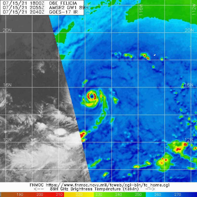
It started as a tropical wave on 12/7 as invest 96E and developed substantially, becoming a tropical cyclone in just two days. Under a rather moist environment in the inter-tropical convergence zone (ITCZ), along with a rare but favourable upper-level environmental and moderate easterly wind shear setup, it significantly intensified with excellent upshear convection. A cold comma was observed at midnight, which indicated a rapid development. The whole rapid intensification process didn’t go very smoothly, however, with occasional dry air intrusion at the western quadrant. According to the NHC, Felicia underwent an eyewall replacement cycle yesterday, though such a view is not really supported firmly by satellite appearance. The only microwave imagery at 15:12UTC 15/7 from METOP-B showed no concentric eyewall, but only a developing eyewall with a fracture at the western side due to the aforementioned dry air intrusion. A later pass at 20:55UTC from AMSR2 showed a healthy, tiny but solid, symmetric eyewall. The tininess of eyewall doesn’t support NHC’s claim as well as an eyewall replacement cycle means an expansion in size. Visible imagery also didn’t show a moat (a gap between concentric eyewalls) as well.
Microwave showed that Felicia is tiny, but the structure remains mature and symmetric, which is especially reflected by AMSR2 microwave imagery. Throughout the day, it has been trying its best, wrapping convection from the eastern and southern quadrant to solidify its core gradually as an infrared eye popped out yesterday.
Track Forecast
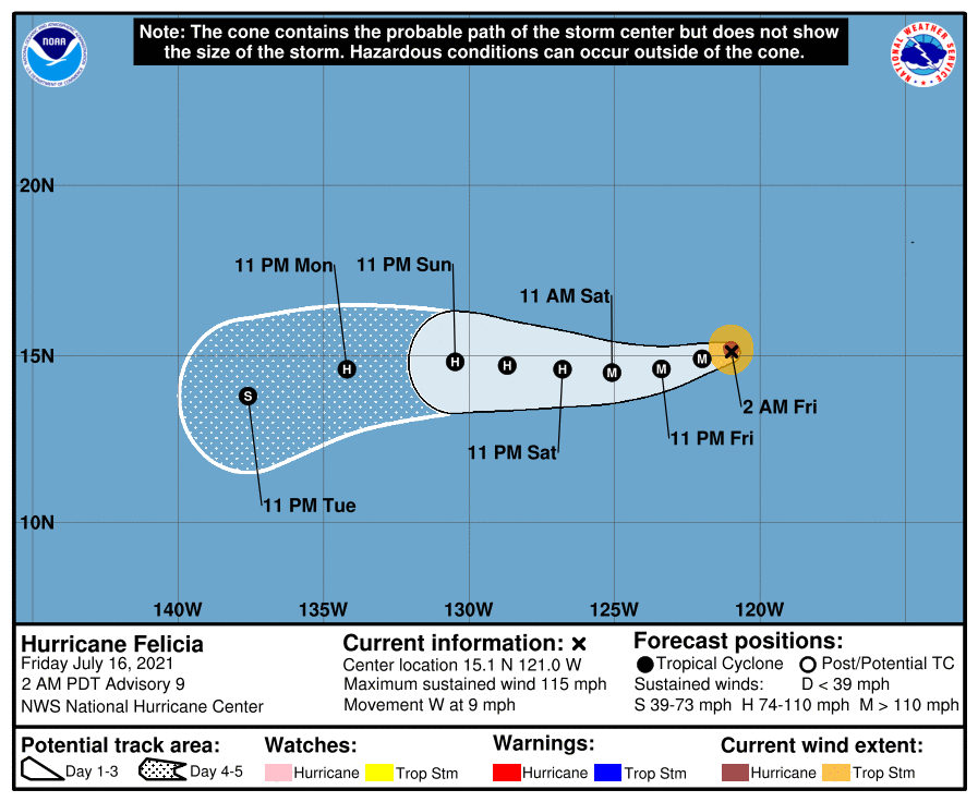
There is a good consensus in terms of track forecast. Felicia is expected to move westward under the influence of the gigantic subtropical Pacific high-pressure area, while the peak is expected to occur after ~6 hours as a hurricane with winds of 125mph. After that, as it approaches a pool of dry air north of the ITCZ, along with declining sea surface temperatures. These factors are expected to cause it to weaken gradually, down to a tropical storm after day 4. From the forecast track, it will remain over the open Eastern Pacific, so no land areas are expected to get any impact from Felicia.
Elsewhere in the tropics, there’re also 97E, 99L, 09W (FabianPH), and 99W. Invest 97E follows behind Felicia with a high chance of formation. Invest 99L is dying off in the subtropical Atlantic. Invest 09W has been designated and is expected to become a significant typhoon that strikes the Japanese Islands and China. Last but not least, invest 99W in the South China Sea is expected to have slight development with a low chance of formation.
