Jan 24 - 26: Maintenance on Sector imagery. Some products may become temporarily unavailable.
Real-time Cyclone Tracker
Select a Storm:
- Latest Information -
As of January 24th 2026 at 16:01 UTC
Tropical Storm Luana was located near 17.3°S, 123°E, or about 68 miles (109 km) northeast of Broome, Western Australia. Luana has maximum sustained winds of 50 knots and a minimum central pressure of 987 millibars.
Sea surface temperatures are around 29.5°C (85.1°F).
Invest 90P was located near 17.7°S, 154.1°E, or about 156 miles (252 km) northeast of Marion Reef, Queensland. 90P has maximum sustained winds of 20 knots and a minimum central pressure of 1006 millibars.
Sea surface temperatures are around 28.5°C (83.3°F).
Invest 92P was located near 15.8°S, 141.8°E, or about 166 miles (268 km) east-northeast of Mornington Island, Queensland. 92P has maximum sustained winds of 20 knots and a minimum central pressure of 1004 millibars.
Sea surface temperatures are around 29.5°C (85.1°F).
Subtropical Depression Sixteen was located near 27.5°S, 172.9°W, or about 463 miles (745 km) south-southeast of Tonga. Sixteen has maximum sustained winds of 25 knots and a minimum central pressure of 997 millibars.
Sea surface temperatures are around 26.5°C (79.7°F).
But there is suppost to be plenty of windshear were it is, it is not going to hit any land and it will die very soon!!!
acay
1 year ago
Why is there an ad telling me to download before continuing? Im just checking the PTC-5 and it poped up. I was still able to skip it, but what if i accidentally clicked/tapped on it, then what could possibly happen to me? That was rather concerning, and it would be nice if there are answers to this
I once clicked on it thinking it was an actual download button. It took me to a gaming website, but sometimes I got a possible scamming website so just avoid clicking on those buttons.
Lol
1 year ago
Son-tinh has just been named!
acay
1 year ago
Can u guys list factors that can affect a tropical cyclone’s intensity?

 View more imagery Animated GIF
 View more precip products
 View more radar products Animated GIF
 View more SST products
 View more surface plot products
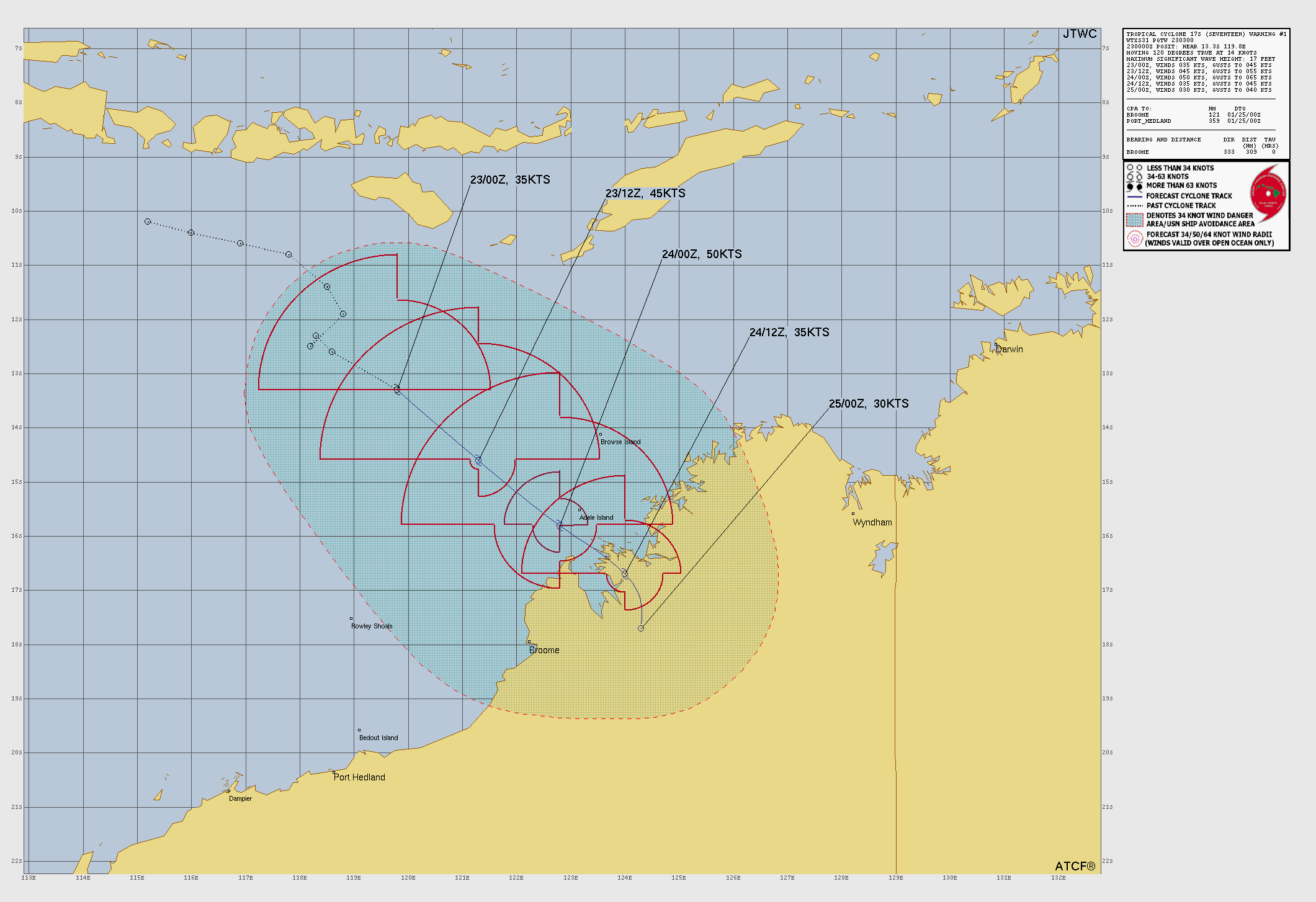 Visit the JTWC website


I Toataly underestimated Ernesto It is 90 Mph
I’m supprized with Hurricane Ernesto
two new potential invests in WPAC (not the current ones) in the open seas
how much does the website earn from ads?
both of the storms are sheared heavily
ight im gonna try to list all of the conditions that can affect a tropical cyclone:
I must have missed something that I dont know, so that would be nice if someone can fix or add more. thanks
And the important one: Coriolis effect
And the Coriolis Force
Is it just me or does Typhoon Ampil looks like Typhoon Wutip of 2019 just rotated 90 degrees clockwise
Ernesto has a huge eye forming
now Ampil is an annular typhoon
Ampil now does look like Dorian of the 2019 after stalling: weak convection and banding, ragged eye
also, Ernesto is facing some real wind shear,
do note that usually the high wind shear value is caused by the TS’s outflow, that tricks u into thinking the conditions are unfavorable
In the force-13 video it says ernesto will wweaken and head south east and dieout.
Ok, so I think I know ernestos path, it is likely to flow more eastern and weaken along the way, might not even become a hurricane!
Ernesto’s outflow is doing really well if you pay close attention, which is worrying yet fascinating
( equatorward + poleward flow along side)
That outflow is creating a zone of low shear over its core, high shear everywhere else
But there is suppost to be plenty of windshear were it is, it is not going to hit any land and it will die very soon!!!
Why is there an ad telling me to download before continuing? Im just checking the PTC-5 and it poped up. I was still able to skip it, but what if i accidentally clicked/tapped on it, then what could possibly happen to me? That was rather concerning, and it would be nice if there are answers to this
I once clicked on it thinking it was an actual download button. It took me to a gaming website, but sometimes I got a possible scamming website so just avoid clicking on those buttons.
Son-tinh has just been named!
Can u guys list factors that can affect a tropical cyclone’s intensity?
1) Sea surface temperatures
2) Wind shear
3) Mid level humidity
4) Instability
Here is another wind shear map
Wow
F13 noted this in their bulletin last night. Southern Hemisphere activity in August????
i did think tropical storm Fabio was dissipating because of the Fujiwhara and also it was evident that it was weakening due to the satellite imagery