Jan 23 - 26: Maintenance on Sector imagery. Some products may become temporarily unavailable.
Real-time Cyclone Tracker
Select a Storm:
- Latest Information -
As of January 24th 2026 at 00:46 UTC
Invest 90P was located near 17.6°S, 153.3°E, or about 108 miles (174 km) east of Lihou Reef, Queensland. 90P has maximum sustained winds of 25 knots and a minimum central pressure of 997 millibars.
Sea surface temperatures are around 28.5°C (83.3°F).
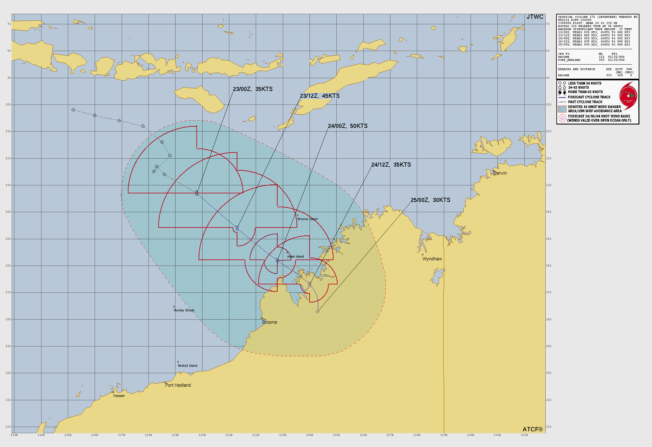
Tropical Storm Seventeen was located near 16°S, 121.4°E, or about 146 miles (236 km) north-northwest of Broome, Western Australia. Seventeen has maximum sustained winds of 45 knots and a minimum central pressure of 994 millibars.
Sea surface temperatures are around 29.5°C (85.1°F).
Invest 92P was located near 15.6°S, 141.7°E, or about 165 miles (266 km) east-northeast of Mornington Island, Queensland. 92P has maximum sustained winds of 30 knots and a minimum central pressure of 1002 millibars.
Sea surface temperatures are around 29.5°C (85.1°F).
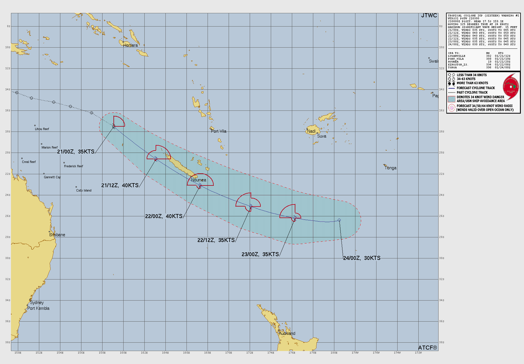
Subtropical Depression Sixteen was located near 26.7°S, 176.6°W, or about 395 miles (635 km) south-southwest of Tonga. Sixteen has maximum sustained winds of 25 knots and a minimum central pressure of 998 millibars.
Sea surface temperatures are around 26.5°C (79.7°F).
ten percent in forty eight hours. we may have our first 2025 epac storm soon.
Force 13 Fanatic
8 months ago
BREAKING NEWS!!!
A disturbed area of weather just off the Pacific coast of Mexico has a 70% chance of development in 7 days. The National Hurricane Center states that an area of low pressure within this region is expected to form early next week, and we cannot rule out further intensification in the near future. More updates will be posted on YouTube. In the meantime, this area will be monitored to see if further development is likely. Stay tuned!
80% now. I think the 48-hour chance is finally going to increase to 10% or above sometime soon.
Jaxon Pynes
8 months ago
70%!!!!!!!! chance for forming !!!!!!!!!
Jaxon Pynes
8 months ago
pacific storm now at 60% chance of forming
casualcyclonetrackerguy
8 months ago
Gotta monitor the marine forecasts! Just because the tropical weather outlooks are primary doesn’t mean marine forecast products aren’t obsolete. Here is the NHC forecast 5 days from now showing that disturbance’s successor quite clearly on the wind 50 meters above sea level.
I pointed that disturbance out earlier, but the 7-day chance became 40% now? Woah.
casualcyclonetrackerguy
8 months ago
I know I was wrong about the May Atlantic major hurricane, but it was appearing on the GFS runs a lot (and now I know to check other models to verify a potential system). Anyways, the NHC has designated a new disturbance in the eastern Pacific now.
Are you trying to use this amount of cable cars to make the first transatlantic cable car in history? If so, give it a lot of strength, there are going to be storms.
Yeah… I doubt that will form as it is not showing up on GFS anymore or really any other model. However it would be crazy to have a Cat 4 to start off the year.

 View more imagery Animated GIF
 View more precip products
 View more radar products Animated GIF
 View more SST products
 View more surface plot products


We might have Alvin soon…
Where is the ‘forecast products’?
90% CHANCE
ten percent in forty eight hours. we may have our first 2025 epac storm soon.
BREAKING NEWS!!!
A disturbed area of weather just off the Pacific coast of Mexico has a 70% chance of development in 7 days. The National Hurricane Center states that an area of low pressure within this region is expected to form early next week, and we cannot rule out further intensification in the near future. More updates will be posted on YouTube. In the meantime, this area will be monitored to see if further development is likely. Stay tuned!
80% now. I think the 48-hour chance is finally going to increase to 10% or above sometime soon.
70%!!!!!!!! chance for forming !!!!!!!!!
pacific storm now at 60% chance of forming
Gotta monitor the marine forecasts! Just because the tropical weather outlooks are primary doesn’t mean marine forecast products aren’t obsolete. Here is the NHC forecast 5 days from now showing that disturbance’s successor quite clearly on the wind 50 meters above sea level.
area of interest in the pacific
I pointed that disturbance out earlier, but the 7-day chance became 40% now? Woah.
I know I was wrong about the May Atlantic major hurricane, but it was appearing on the GFS runs a lot (and now I know to check other models to verify a potential system). Anyways, the NHC has designated a new disturbance in the eastern Pacific now.
YAY
Ok, but i’m still going to keep track of the Atlantic.
🚡🚡🚡🚡🚡🚡🚡🚡🚡🚡🚡🚡🚡🚡🚡🚡🚡🚡🚡🚡🚡🚡🚡🚡🚡🚡🚡🚡🚡🚡🚡🚡🚡🚡🚡🚡🚡🚡🚡🚡🚡🚡🚡🚡🚡🚡🚡🚡🚡🚡🚡🚡🚡🚡🚡🚡🚡🚡🚡🚡🚡🚡🚡🚡🚡🚡🚡🚡🚡🚡🚡🚡🚡🚡🚡🚡🚡🚡🚡🚡🚡🚡🚡🚡🚡🚡🚡🚡🚡🚡🚡🚡🚡🚡🚡🚡🚡🚡🚡🚡🚡🚡🚡🚡🚡🚡🚡🚡🚡🚡🚡🚡🚡🚡🚡🚡🚡🚡🚡🚡🚡🚡🚡🚡🚡🚡🚡🚡 🚡🚡🚡🚡🚡🚡🚡🚡🚡🚡🚡🚡🚡🚡🚡🚡🚡🚡🚡🚡🚡🚡🚡🚡🚡🚡🚡🚡🚡🚡🚡🚡🚡🚡🚡🚡🚡🚡🚡🚡🚡🚡🚡🚡🚡🚡🚡🚡🚡🚡🚡🚡🚡🚡🚡🚡🚡🚡🚡🚡🚡🚡🚡🚡🚡🚡🚡🚡🚡🚡🚡🚡🚡🚡🚡🚡🚡🚡🚡🚡🚡🚡🚡🚡🚡🚡🚡🚡🚡🚡🚡🚡🚡🚡🚡🚡🚡🚡🚡🚡🚡🚡🚡🚡🚡🚡🚡🚡🚡🚡🚡🚡🚡🚡🚡🚡🚡🚡🚡🚡🚡🚡🚡🚡🚡🚡🚡🚡🚡🚡🚡🚡🚡🚡🚡🚡🚡🚡🚡🚡🚡🚡🚡🚡🚡🚡🚡🚡🚡🚡🚡🚡🚡🚡🚡🚡🚡🚡🚡🚡🚡🚡🚡🚡🚡🚡🚡🚡🚡🚡🚡🚡🚡🚡🚡🚡🚡🚡🚡🚡🚡🚡🚡🚡🚡🚡🚡🚡🚡🚡🚡🚡🚡🚡🚡🚡🚡🚡🚡🚡🚡🚡🚡🚡🚡🚡🚡🚡🚡🚡🚡🚡🚡🚡🚡🚡🚡🚡🚡🚡🚡🚡🚡🚡🚡🚡🚡🚡🚡🚡🚡🚡🚡🚡🚡🚡🚡🚡🚡🚡🚡🚡🚡🚡🚡🚡🚡🚡🚡🚡🚡🚡🚡🚡🚡🚡 🚡🚡🚡🚡🚡🚡🚡🚡🚡🚡🚡🚡🚡🚡🚡🚡🚡🚡🚡🚡🚡🚡🚡🚡🚡🚡🚡🚡🚡🚡🚡🚡🚡🚡🚡🚡🚡🚡🚡🚡🚡🚡🚡🚡🚡🚡🚡🚡🚡🚡🚡🚡🚡🚡🚡🚡🚡🚡🚡🚡🚡🚡🚡🚡🚡🚡🚡🚡🚡🚡🚡🚡🚡🚡🚡🚡🚡🚡🚡🚡🚡🚡🚡🚡🚡🚡🚡🚡🚡🚡🚡🚡🚡🚡🚡🚡🚡🚡🚡🚡🚡🚡🚡🚡🚡🚡🚡🚡🚡🚡🚡🚡🚡🚡🚡🚡🚡🚡🚡🚡🚡🚡🚡🚡🚡🚡🚡🚡🚡🚡🚡🚡🚡🚡🚡🚡🚡🚡🚡🚡🚡🚡🚡🚡🚡🚡🚡🚡🚡🚡🚡🚡🚡🚡🚡🚡🚡🚡🚡🚡🚡🚡🚡🚡🚡🚡🚡🚡🚡🚡🚡🚡🚡🚡🚡🚡🚡🚡🚡🚡🚡🚡🚡🚡🚡🚡🚡🚡🚡🚡🚡🚡🚡🚡🚡🚡🚡🚡🚡🚡🚡🚡🚡🚡🚡🚡🚡🚡🚡🚡🚡🚡🚡🚡🚡🚡🚡🚡🚡🚡🚡🚡🚡🚡🚡🚡🚡🚡🚡🚡🚡🚡🚡🚡🚡🚡🚡🚡🚡🚡🚡🚡🚡🚡🚡🚡🚡🚡🚡🚡🚡🚡🚡🚡🚡🚡 🚡🚡🚡🚡🚡🚡🚡🚡🚡🚡🚡🚡🚡🚡🚡🚡🚡🚡🚡🚡🚡🚡🚡🚡🚡🚡🚡🚡🚡🚡🚡🚡🚡🚡🚡🚡🚡🚡🚡🚡🚡🚡🚡🚡🚡🚡🚡🚡🚡🚡🚡🚡🚡🚡🚡🚡🚡🚡🚡🚡🚡🚡🚡🚡🚡🚡🚡🚡🚡🚡🚡🚡🚡🚡🚡🚡🚡🚡🚡🚡🚡🚡🚡🚡🚡🚡🚡🚡🚡🚡🚡🚡🚡🚡🚡🚡🚡🚡🚡🚡🚡🚡🚡🚡🚡🚡🚡🚡🚡🚡🚡🚡🚡🚡🚡🚡🚡🚡🚡🚡🚡🚡🚡🚡🚡🚡🚡🚡🚡🚡🚡🚡🚡🚡🚡🚡🚡🚡🚡🚡🚡🚡🚡🚡🚡🚡🚡🚡🚡🚡🚡🚡🚡🚡🚡🚡🚡🚡🚡🚡🚡🚡🚡🚡🚡🚡🚡🚡🚡🚡🚡🚡🚡🚡🚡🚡🚡🚡🚡🚡🚡🚡🚡🚡🚡🚡🚡🚡🚡🚡🚡🚡🚡🚡🚡🚡🚡🚡🚡🚡🚡🚡🚡🚡🚡🚡🚡🚡🚡🚡🚡🚡🚡🚡🚡🚡🚡🚡🚡🚡🚡🚡🚡🚡🚡🚡🚡🚡🚡🚡🚡🚡🚡🚡🚡🚡🚡🚡🚡🚡🚡🚡🚡🚡🚡🚡🚡🚡🚡🚡🚡🚡🚡🚡🚡🚡 🚡🚡🚡🚡🚡🚡🚡🚡🚡🚡🚡🚡🚡🚡🚡🚡🚡🚡🚡🚡🚡🚡🚡🚡🚡🚡🚡🚡🚡🚡🚡🚡🚡🚡🚡🚡🚡🚡🚡🚡🚡🚡🚡🚡🚡🚡🚡🚡🚡🚡🚡🚡🚡🚡🚡🚡🚡🚡🚡🚡🚡🚡🚡🚡🚡🚡🚡🚡🚡🚡🚡🚡🚡🚡🚡🚡🚡🚡🚡🚡🚡🚡🚡🚡🚡🚡🚡🚡🚡🚡🚡🚡🚡🚡🚡🚡🚡🚡🚡🚡🚡🚡🚡🚡🚡🚡🚡🚡🚡🚡🚡🚡🚡🚡🚡🚡🚡🚡🚡🚡🚡🚡🚡🚡🚡🚡🚡🚡
WTH
WTF
Are you trying to use this amount of cable cars to make the first transatlantic cable car in history? If so, give it a lot of strength, there are going to be storms.
Yes
Yes for what
I know
potential storm near Barbados
Do you think this is a storm
It might be a possibility
Where is it
EPAC
good rotation
storm
Potential storm near panama
HOW IS THE GULF STORM NOT MARKED YET?!?
WAKE UP NHC
subtropical
Is no one else talking about the storm in Gulf of “AMERICA” that could possibly develop?
Is no body goignt o talk about when the 2025 Atlantic Hurricane Season will start?
Supposed to peak around New Orleans area, I predict 35mph tropical depression.
We could have our first tropical system by tonight if NHC wakes the heck up.
Is literally NO ONE going to talk about that Atlantic hurricane on the 18Z GFS model run?
You mean that early tropical depression THAT WILL NEVER FORM?!!
Yeah… I doubt that will form as it is not showing up on GFS anymore or really any other model. However it would be crazy to have a Cat 4 to start off the year.