Jan 23 - 26: Maintenance on Sector imagery. Some products may become temporarily unavailable.
Real-time Cyclone Tracker
Select a Storm:
- Latest Information -
As of January 23rd 2026 at 23:16 UTC
Invest 90P was located near 17.6°S, 153.3°E, or about 108 miles (174 km) east of Lihou Reef, Queensland. 90P has maximum sustained winds of 25 knots and a minimum central pressure of 997 millibars.
Sea surface temperatures are around 28.5°C (83.3°F).
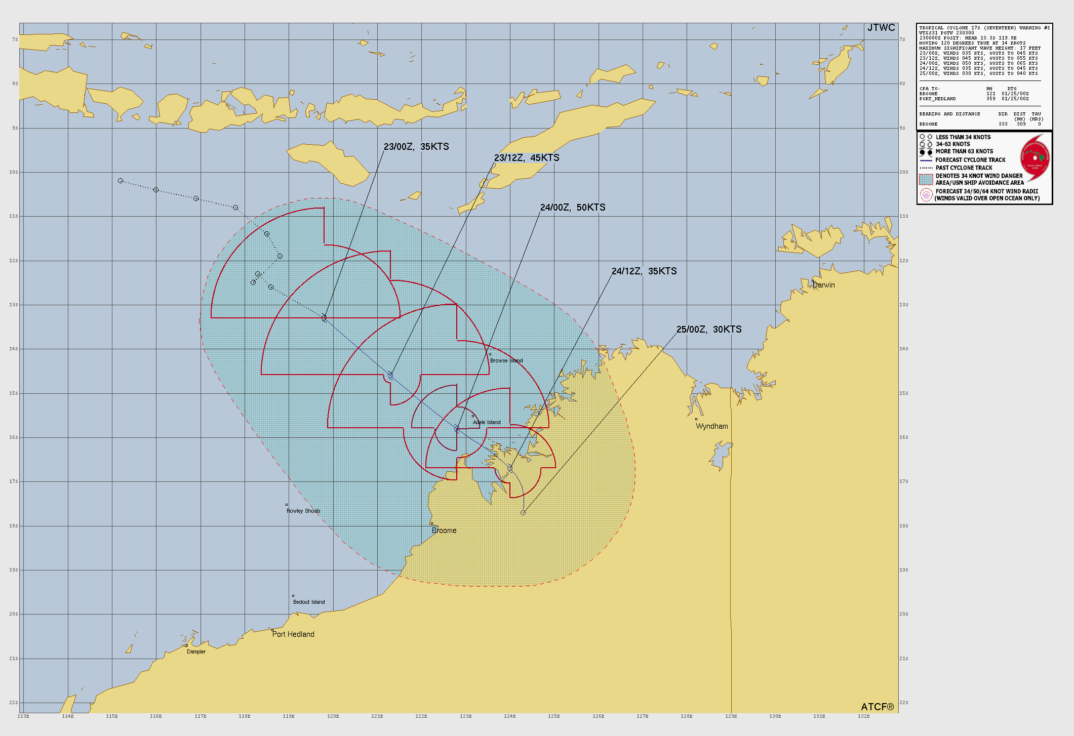
Tropical Storm Seventeen was located near 16°S, 121.4°E, or about 146 miles (236 km) north-northwest of Broome, Western Australia. Seventeen has maximum sustained winds of 45 knots and a minimum central pressure of 994 millibars.
Sea surface temperatures are around 29.5°C (85.1°F).
Invest 92P was located near 15.6°S, 141.7°E, or about 165 miles (266 km) east-northeast of Mornington Island, Queensland. 92P has maximum sustained winds of 30 knots and a minimum central pressure of 1002 millibars.
Sea surface temperatures are around 29.5°C (85.1°F).
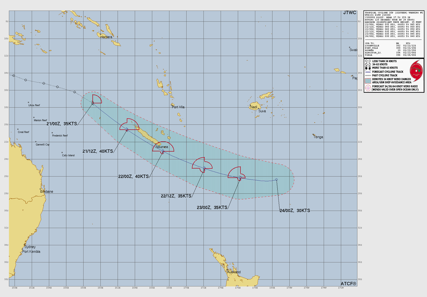
Subtropical Depression Sixteen was located near 26.7°S, 176.6°W, or about 395 miles (635 km) south-southwest of Tonga. Sixteen has maximum sustained winds of 25 knots and a minimum central pressure of 998 millibars.
Sea surface temperatures are around 26.5°C (79.7°F).
Tropical plot twist: Something we did nto expect, there are 2 tropical systems in the coast of western Mexico, a plot twist that NO ONE ASKED FOR.
Disturbance 1- %in the next 2 days:40 | % in the next 7 days:80 Disturbance 2- %in the next 2 days:10 | %in the next 7 days:40
My forecast: Over the next several weeks, Disturbance 1 will form first, and whether it becomes a tropical storm or a major hurricane, it could interfere with the path of disturbance 2 which would form more later, some of the energy that the second system has been using has been stolen by disturbance 1. Disturbance 1 looks like it could head more north, and disturbance 2 looks like it could drift north west.
F0rce-23/FAN
7 months ago
Updates on the atlantic oceanic heat: It is really warm in the gulf of America, storms could form in a few days due to the obserd amount of heat. It is really hot, there have been many reports of above average heat. The NHC has issued a heat warning in the Gulf Coast and near Columbia.
Shi- I can’t edit the pos,t dang it. OK, just in case you think the post was real, no, the Atlantic Ocean is not full of lava right now, it is very silent and suspiciously inactive.
F0rce-23/FAN
7 months ago
Atlantic inactivity
Over the past few days, there has been no Atlantic storms, and there is not expected for there to be other systems for the next week or so, this can point to there being an expected average to slightly more than average hurricane season.
F0rce-23/FAN
7 months ago
Today I figured out: How to make a phonk video | How to edit images |
F0rce-23/FAN
7 months ago
Ok, why aren’t they tracking the tropical system near western Mexico? Update: 30% development in the next 48 hours, 80% in the next 7 days. Force-13, please update this.
Don’t worry 35° is average for June. It will go up to 40° in September. You just time traveled to year 3500. The strongest storm as of now is Typhoon Isi-ga (made-up name) which was 405mph 698mbar in 3402. You may go back to 2025. The image is fixed now.
casualcyclonetrackerguy
7 months ago
what the- (I CAN’T EDIT THE IMAGE??? I ACCIDENTALLY PUT THE PERIOD OF THE FIRST SENTENCE IN THE 90% RED HIGHLIGHT)
If you’re talking about my screenshots, I used the element inspection tool and edited the HTML content of the page. If you’re talking about F0RCE-23/FAN’s screenshots, details seem to have been added in with an image manipulation tool.
F0rce-23/FAN
7 months ago
Nevermind, it is going to form in 2-5 days! 80% in 2 days!
F0rce-23/FAN
7 months ago
The disturbance in the Pacific is going to form in 7 days, probably next week. It could be a major hurricane.
F0rce-23/FAN
7 months ago
The dissipation of the atlantic disturbance, it currently has a 0% chance of formation in the next 48 hours, and a 0% chance of development in the next 7 days, This can tell us that this hurricane season could be near average.
F0rce-23/FAN
7 months ago
You know how bad the 2025 atlantic hurricane season is going to be bad when it says “There are currently no cyclones active”.
The disturbance on the western coast of Mexico will be forming more, it went from 40% in the next 7 days, to 60% chance of formation in the next 7 days, this means that it could form into a tropical storm by next week.
ALRIGHT! The disturbance has been marked, and has a 48-hour formation chance now. The NHC outlook in the form of raw text below shows that this could be a subtropical or tropical development.
Offshore of the Southeastern U.S. Coast: A non-tropical area of low pressure is forecast to form near or offshore of the southeastern U.S. coast along a frontal boundary during the next couple of days. If the low remains offshore, it could gradually develop some subtropical or tropical characteristics later this week while moving northeastward at 10 to 15 mph. * Formation chance through 48 hours…low…10 percent. * Formation chance through 7 days…low…10 percent.
FIRST HURRICANE OF THE SEASON!!! My guess is that it could be a category 2 storm near the carolinas, hopefully it should start drifting more in the northeast direction off to sea.
Umm… isn’t it still a disturbance? Also, SSTs are rather cool right now with around 28ºC offshore of the Carolinas, transitioning into around 25ºC northeast of there. If it were to be a storm, it would probably need really cold air in the 500mb part of the atmosphere to sustain itself in later stages. I forecast at most category 1.
Nevermind, if it drifts northeast, it could strengthen off to sea maybe a category 2, or even a spicy category 3. However, this forecast (imaginary) is still weeks in advance; in fact, the system might dissipate.
F0rce-23/fan
7 months ago
FINALLY SOMETHING IN THE ATLANTIC!!! Unfortunately, it won’t have any major development, but I expect this disturbance on the southeastern coast of America to strengthen from next week to the week after, likely. I will report on it on YouTube. It has a 0% likelihood of forming into a major storm system or tropical storm in the next 2 days, and a 10% chance of formation in the next week. 10% is a major development for weak storms that are unlikely to form. And if it does form, we are ready to report on it to make sure nobody gets hurt.
F0rce-23/FAN
7 months ago
I can’t let anybody make a YouTube weather report on this before me. Also, F13F, once again, as a reminder, you can report on all other basins, but I report on the Atlantic.
casualcyclonetrackerguy
7 months ago
That feeling when the first actually in-season Atlantic invest’s potential formation area is rather unusual:
Anonimaus
7 months ago
I REALLY missed the custom-satellite generator that was available in 2021…

 View more imagery Animated GIF
 View more precip products
 View more radar products Animated GIF
 View more SST products
 View more surface plot products


Tropical plot twist: Something we did nto expect, there are 2 tropical systems in the coast of western Mexico, a plot twist that NO ONE ASKED FOR.
Disturbance 1- %in the next 2 days:40 | % in the next 7 days:80 Disturbance 2- %in the next 2 days:10 | %in the next 7 days:40
My forecast: Over the next several weeks, Disturbance 1 will form first, and whether it becomes a tropical storm or a major hurricane, it could interfere with the path of disturbance 2 which would form more later, some of the energy that the second system has been using has been stolen by disturbance 1. Disturbance 1 looks like it could head more north, and disturbance 2 looks like it could drift north
west.
Updates on the atlantic oceanic heat: It is really warm in the gulf of America, storms could form in a few days due to the obserd amount of heat. It is really hot, there have been many reports of above average heat. The NHC has issued a heat warning in the Gulf Coast and near Columbia.
Ok it was funny once, but posting edited images with captions like these in a more serious update manner could misinform readers.
Shi- I can’t edit the pos,t dang it. OK, just in case you think the post was real, no, the Atlantic Ocean is not full of lava right now, it is very silent and suspiciously inactive.
Atlantic inactivity
Over the past few days, there has been no Atlantic storms, and there is not expected for there to be other systems for the next week or so, this can point to there being an expected average to slightly more than average hurricane season.
Today I figured out: How to make a phonk video | How to edit images |
Ok, why aren’t they tracking the tropical system near western Mexico? Update: 30% development in the next 48 hours, 80% in the next 7 days. Force-13, please update this.
The two potential interest are beginning to show up on high seas forecast warnings.
Oh wait- why is the Pacific Ocean near Invest 92W so hot?
I thought this was real for a second… I had to take a moment to realize this was edited. Also, my zoom earth isn’t zoom earthing.
Don’t worry 35° is average for June. It will go up to 40° in September. You just time traveled to year 3500. The strongest storm as of now is Typhoon Isi-ga (made-up name) which was 405mph 698mbar in 3402. You may go back to 2025. The image is fixed now.
what the-
(I CAN’T EDIT THE IMAGE??? I ACCIDENTALLY PUT THE PERIOD OF THE FIRST SENTENCE IN THE 90% RED HIGHLIGHT)
fixed image
(side note: this was hypertranslated 100 times)
OK, final post of editing google earth;s hurricane tracker:
AINT NO WAY THIS SYSTEM GOT TO BE BREAKIGN RECORDS WTF 💀
not the obvious editing 💀 (please tell me this is a joke post)
NAHHH 💀💀💀💀💀
No way bro used inspect element tool. I used a better software.
Blud knocked the wind out of me 💀
This one is also pretty good as well
Whoever made this photo did a really good job of blending in the edited parts with the unedited parts
If you’re talking about my screenshots, I used the element inspection tool and edited the HTML content of the page.
If you’re talking about F0RCE-23/FAN’s screenshots, details seem to have been added in with an image manipulation tool.
Nevermind, it is going to form in 2-5 days! 80% in 2 days!
The disturbance in the Pacific is going to form in 7 days, probably next week. It could be a major hurricane.
The dissipation of the atlantic disturbance, it currently has a 0% chance of formation in the next 48 hours, and a 0% chance of development in the next 7 days, This can tell us that this hurricane season could be near average.
You know how bad the 2025 atlantic hurricane season is going to be bad when it says “There are currently no cyclones active”.
2025 Atlantic is coming soon
Only in Ohio- I mean Limenade_gamin’.
Are you the reincarnation of Limenade Gaming?
The disturbance on the western coast of Mexico will be forming more, it went from 40% in the next 7 days, to 60% chance of formation in the next 7 days, this means that it could form into a tropical storm by next week.
Now it’s 70% in 7 days.
ALRIGHT! The disturbance has been marked, and has a 48-hour formation chance now. The NHC outlook in the form of raw text below shows that this could be a subtropical or tropical development.
Offshore of the Southeastern U.S. Coast:
A non-tropical area of low pressure is forecast to form near or
offshore of the southeastern U.S. coast along a frontal boundary
during the next couple of days. If the low remains offshore, it
could gradually develop some subtropical or tropical characteristics
later this week while moving northeastward at 10 to 15 mph.
* Formation chance through 48 hours…low…10 percent.
* Formation chance through 7 days…low…10 percent.
FIRST HURRICANE OF THE SEASON!!! My guess is that it could be a category 2 storm near the carolinas, hopefully it should start drifting more in the northeast direction off to sea.
Umm… isn’t it still a disturbance? Also, SSTs are rather cool right now with around 28ºC offshore of the Carolinas, transitioning into around 25ºC northeast of there. If it were to be a storm, it would probably need really cold air in the 500mb part of the atmosphere to sustain itself in later stages. I forecast at most category 1.
Nevermind, if it drifts northeast, it could strengthen off to sea maybe a category 2, or even a spicy category 3. However, this forecast (imaginary) is still weeks in advance; in fact, the system might dissipate.
FINALLY SOMETHING IN THE ATLANTIC!!! Unfortunately, it won’t have any major development, but I expect this disturbance on the southeastern coast of America to strengthen from next week to the week after, likely. I will report on it on YouTube. It has a 0% likelihood of forming into a major storm system or tropical storm in the next 2 days, and a 10% chance of formation in the next week. 10% is a major development for weak storms that are unlikely to form. And if it does form, we are ready to report on it to make sure nobody gets hurt.
I can’t let anybody make a YouTube weather report on this before me. Also, F13F, once again, as a reminder, you can report on all other basins, but I report on the Atlantic.
That feeling when the first actually in-season Atlantic invest’s potential formation area is rather unusual:
I REALLY missed the custom-satellite generator that was available in 2021…
tbh it’s getting so hard to generate gif loops for a specific undesignated area of interest