Invest 90P was located near 17.6°S, 153.3°E, or about 108 miles (174 km) east of Lihou Reef, Queensland. 90P has maximum sustained winds of 25 knots and a minimum central pressure of 997 millibars.
Sea surface temperatures are around 28.5°C (83.3°F).
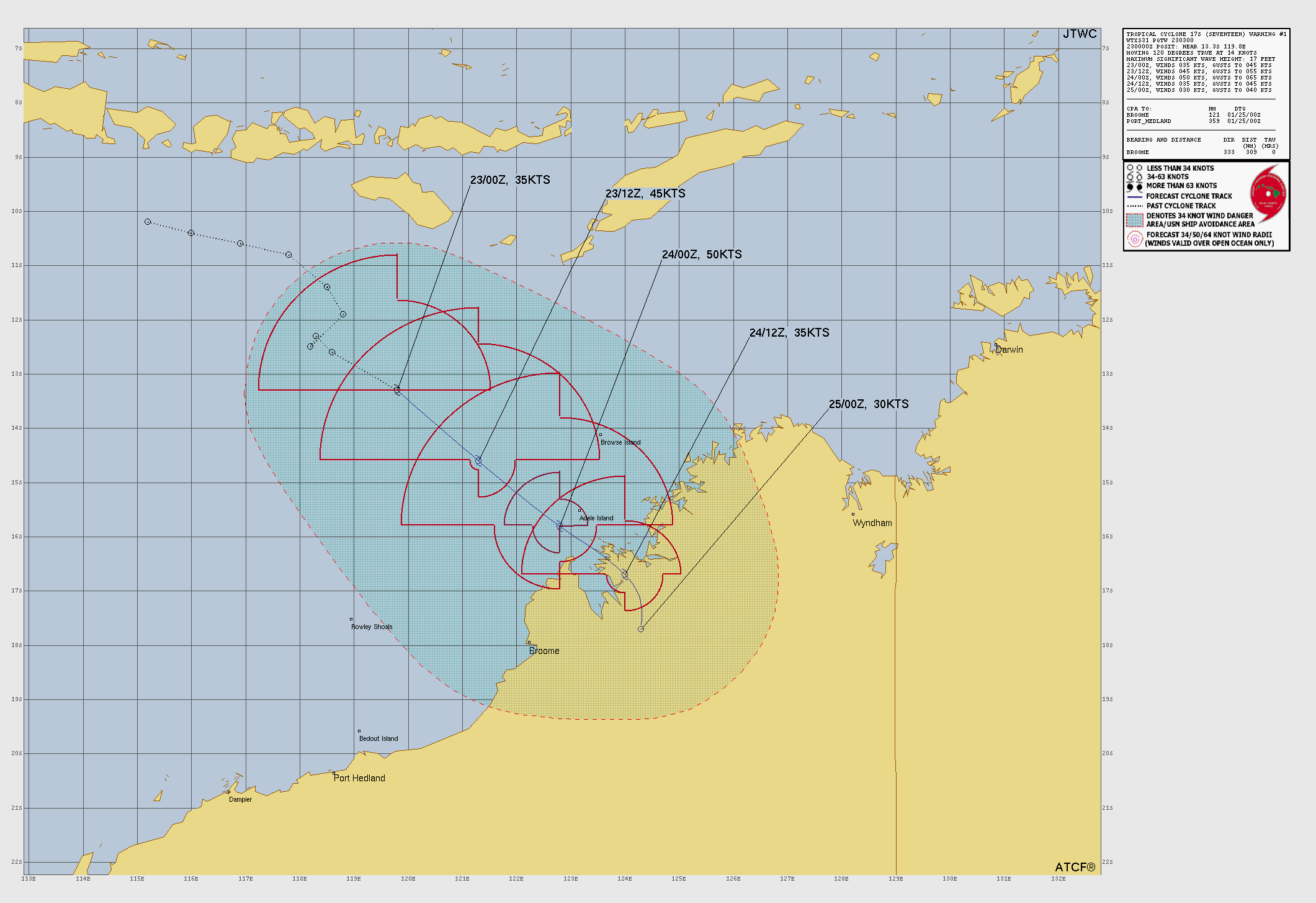
Tropical Storm Seventeen was located near 16°S, 121.4°E, or about 146 miles (236 km) north-northwest of Broome, Western Australia. Seventeen has maximum sustained winds of 45 knots and a minimum central pressure of 994 millibars.
Sea surface temperatures are around 29.5°C (85.1°F).
Invest 92P was located near 15.6°S, 141.7°E, or about 165 miles (266 km) east-northeast of Mornington Island, Queensland. 92P has maximum sustained winds of 30 knots and a minimum central pressure of 1002 millibars.
Sea surface temperatures are around 29.5°C (85.1°F).
Subtropical Depression Sixteen was located near 26.7°S, 176.6°W, or about 395 miles (635 km) south-southwest of Tonga. Sixteen has maximum sustained winds of 25 knots and a minimum central pressure of 998 millibars.
Sea surface temperatures are around 26.5°C (79.7°F).
Now I’m going to try to make a design similar to that 😀
F0rce-23/FAN
6 months ago
Update on my schedule: Im not going to go to Florida until July 15th, therefore I have time to do some tracking in the Atlantic. That means that I want f13f to stop making videos on the Atlantic until I go to Florida, as I will post youtube videos of tracking in the atlantic.
|91L Update 1| So, 91L unexpected began to form over the bay of Campeche, and day by day it is slowly intensifying. Right now it is over temperatures of 28 degrees Celsius, as it was expected to diminish, it hasn’t. It has a 30% chance of forming into a tropical storm. If it doesn’t diminish, it will intensify, but unlikely rapidly intensify. It will make landfall in either Texas, northeastern Mexico, or Mississippi as either a tropical storm, or category 1 hurricane.
Then how is it not dissipating overland yet? Also, it will probably shift northwest and make landfall in one of the northwestern gulf of American states.
Just disappear over land, like it is impossible for the system to reorganize into a tropical storm and make landfall in Texas or northern Mexico.
F0rce-23/FAN
6 months ago
I BROKE MY SCREEN but is this the only time it has happened? No, I BROKE the dang weak screen so many times I lost count. Is this related to cyclones? No, go on, get scrolling.
I’ve been asking myself that for the past several years.
casualcyclonetrackerguy
6 months ago
I’m going to make a website with Neocities where I cover tropical cyclones worldwide to the best of my ability.
Chaban Jad
6 months ago
I need to display a part of the Force Thirteen website onto a WebView2 as the navigation bar is blocking the view. If a setting that can hide the navigation bar exists, then it would very much help me with creating the Force 13 cyclone tracker for Windows
Hurricane
6 months ago
I bet it will not form. Conditions look good for gradual development but limited time over water could stop development.
Potentially, as a Ridge near Florida is forecast to break down, but the influence of the larger and more powerful 95E could also steer it westward as it forms. It’s not organized enough to act on its own authority, shall I say.
F0rce-23/FAN
6 months ago
Sorry F13F, you can go ahead and post Atlantic updates on youtube(for now), as until the end of July I will be vacationing in Mexico beach, Florida.
F0rce-23/FAN
6 months ago
!!!ANOTHER TROPICAL DISTURBANCE EAST OF BELIZE CITY!!!
casualcyclonetrackerguy
6 months ago
We now have a low-chance disturbance in the extreme western Caribbean that could form in the Bay of Campeche. It could be Barry, it could be 02L, or it could just be a disappointment.
Atlantic: NO tropical cyclone development is expected in the next 7 days, says the NHC. However, by June 29, a low is forecast to form near the Bay of Campeche.
Pacific, east of 180W: Invest 95E is looking organized and is expected to become Flossie very soon. This basin is on steroids.
Pacific, west of 180W: Tropical Depressions Two (Sepat) and Three are active. Sepat is looking like it will affect Japan a little and then dissipate, and Three will just die out as it makes landfall.
Indian Ocean: This basin is just quiet. Last season to not have a named storm yet this year (as of 6/25/25). Shakhti is the next named storm.
Southern Hemisphere: Nothing to discuss until a disturbed area of weather forms.
Don’t forget 97W, which the GFS keeps predicting to be a strong storm.
F0rce-23/fan
6 months ago
It’s alright for there to be ads here, but if they add anymore ads to the point where it becomes unbearably laggy, I will be unsubscribing. You already receive income from YouTube ads; please don’t add any more ads.
Andrea’s post-tropical now. Only lasted 2 advisories (3 including declaration of post-tropical status).
F0rce-23/fan
6 months ago
(HYPOTHETICAL)|Update 6 on the Atlantic Hurricane season | System 16L is now located at 22°38’28.9″N 73°13’27.1″, it has a windspeed of 28 miles an hour, and has a 65% chance of formation in the next 2 days, and a 95% chance of formation in the next 7 days, with a pressure in millbars of 1018. It is forecasted to continue drifting northwest, possibly forming into a tropical storm by next week.
F0rce-23/fan
6 months ago
To Force13Fanatic, I know I may be immature here, but I told you that you could do anything except report on the Atlantic, as I would do that; however, you ignored me. If this continues, I will no longer collaborate with you.

 View more imagery Animated GIF
 View more precip products
 View more radar products Animated GIF
 View more SST products
 View more surface plot products


LET’S GOOOOOOOOOOO
oh also take a look! a cursed image from the nhc website
It’s 70% now…
THAT’S [[Right]], AL91 IS LIKELY TO FORM IN THE [[Atlantic Ocean]] SOON!!!
What do you guys think about this format?
Not bad not gonna lie it is pretty good
Now I’m going to try to make a design similar to that 😀
Update on my schedule: Im not going to go to Florida until July 15th, therefore I have time to do some tracking in the Atlantic. That means that I want f13f to stop making videos on the Atlantic until I go to Florida, as I will post youtube videos of tracking in the atlantic.
40% formation chance for 91L.
Its going to be a tropical storm
|91L Update 1| So, 91L unexpected began to form over the bay of Campeche, and day by day it is slowly intensifying. Right now it is over temperatures of 28 degrees Celsius, as it was expected to diminish, it hasn’t. It has a 30% chance of forming into a tropical storm. If it doesn’t diminish, it will intensify, but unlikely rapidly intensify. It will make landfall in either Texas, northeastern Mexico, or Mississippi as either a tropical storm, or category 1 hurricane.
I doubt 91L will intensify into a hurricane and/or curve into the northeast of the Gulf of Mexico.
Then how is it not dissipating overland yet? Also, it will probably shift northwest and make landfall in one of the northwestern gulf of American states.
I think weak lows can survive over land. It’s strong lows with low-level circulations that experience land interference.
IS IT REALLY 91L ALREADY???
PLS DISSIPATE
Did you forget to add a don’t? Sorry if this bugs you.
Just disappear over land, like it is impossible for the system to reorganize into a tropical storm and make landfall in Texas or northern Mexico.
I BROKE MY SCREEN but is this the only time it has happened? No, I BROKE the dang weak screen so many times I lost count. Is this related to cyclones? No, go on, get scrolling.
how?
I’ve been asking myself that for the past several years.
I’m going to make a website with Neocities where I cover tropical cyclones worldwide to the best of my ability.
I need to display a part of the Force Thirteen website onto a WebView2 as the navigation bar is blocking the view. If a setting that can hide the navigation bar exists, then it would very much help me with creating the Force 13 cyclone tracker for Windows
I bet it will not form. Conditions look good for gradual development but limited time over water could stop development.
Does it look like it could begin drifting north? No?
Potentially, as a Ridge near Florida is forecast to break down, but the influence of the larger and more powerful 95E could also steer it westward as it forms. It’s not organized enough to act on its own authority, shall I say.
Sorry F13F, you can go ahead and post Atlantic updates on youtube(for now), as until the end of July I will be vacationing in Mexico beach, Florida.
!!!ANOTHER TROPICAL DISTURBANCE EAST OF BELIZE CITY!!!
We now have a low-chance disturbance in the extreme western Caribbean that could form in the Bay of Campeche. It could be Barry, it could be 02L, or it could just be a disappointment.
I SWEAR IF THIS DISSIPATES I WILL SLAM MY COMPUTER MONITOR
NOOOOOO My computer monitor is broken shi-
I will not delete the video, Force 23.
Worldwide Tropical Cyclone News Super Lite:
Atlantic:
NO tropical cyclone development is expected in the next 7 days, says the NHC. However, by June 29, a low is forecast to form near the Bay of Campeche.
Pacific, east of 180W:
Invest 95E is looking organized and is expected to become Flossie very soon. This basin is on
steroids.Pacific, west of 180W:
Tropical Depressions Two (Sepat) and Three are active. Sepat is looking like it will affect Japan a little and then dissipate, and Three will just die out as it makes landfall.
Indian Ocean:
This basin is just quiet. Last season to not have a named storm yet this year (as of 6/25/25). Shakhti is the next named storm.
Southern Hemisphere: Nothing to discuss until a disturbed area of weather forms.
Don’t forget 97W, which the GFS keeps predicting to be a strong storm.
It’s alright for there to be ads here, but if they add anymore ads to the point where it becomes unbearably laggy, I will be unsubscribing. You already receive income from YouTube ads; please don’t add any more ads.
Use an adblocker! I use Pie
Andrea’s post-tropical now. Only lasted 2 advisories (3 including declaration of post-tropical status).
(HYPOTHETICAL)|Update 6 on the Atlantic Hurricane season | System 16L is now located at 22°38’28.9″N 73°13’27.1″, it has a windspeed of 28 miles an hour, and has a 65% chance of formation in the next 2 days, and a 95% chance of formation in the next 7 days, with a pressure in millbars of 1018. It is forecasted to continue drifting northwest, possibly forming into a tropical storm by next week.
To Force13Fanatic, I know I may be immature here, but I told you that you could do anything except report on the Atlantic, as I would do that; however, you ignored me. If this continues, I will no longer collaborate with you.