Invest 90P was located near 17.6°S, 153.3°E, or about 108 miles (174 km) east of Lihou Reef, Queensland. 90P has maximum sustained winds of 25 knots and a minimum central pressure of 997 millibars.
Sea surface temperatures are around 28.5°C (83.3°F).
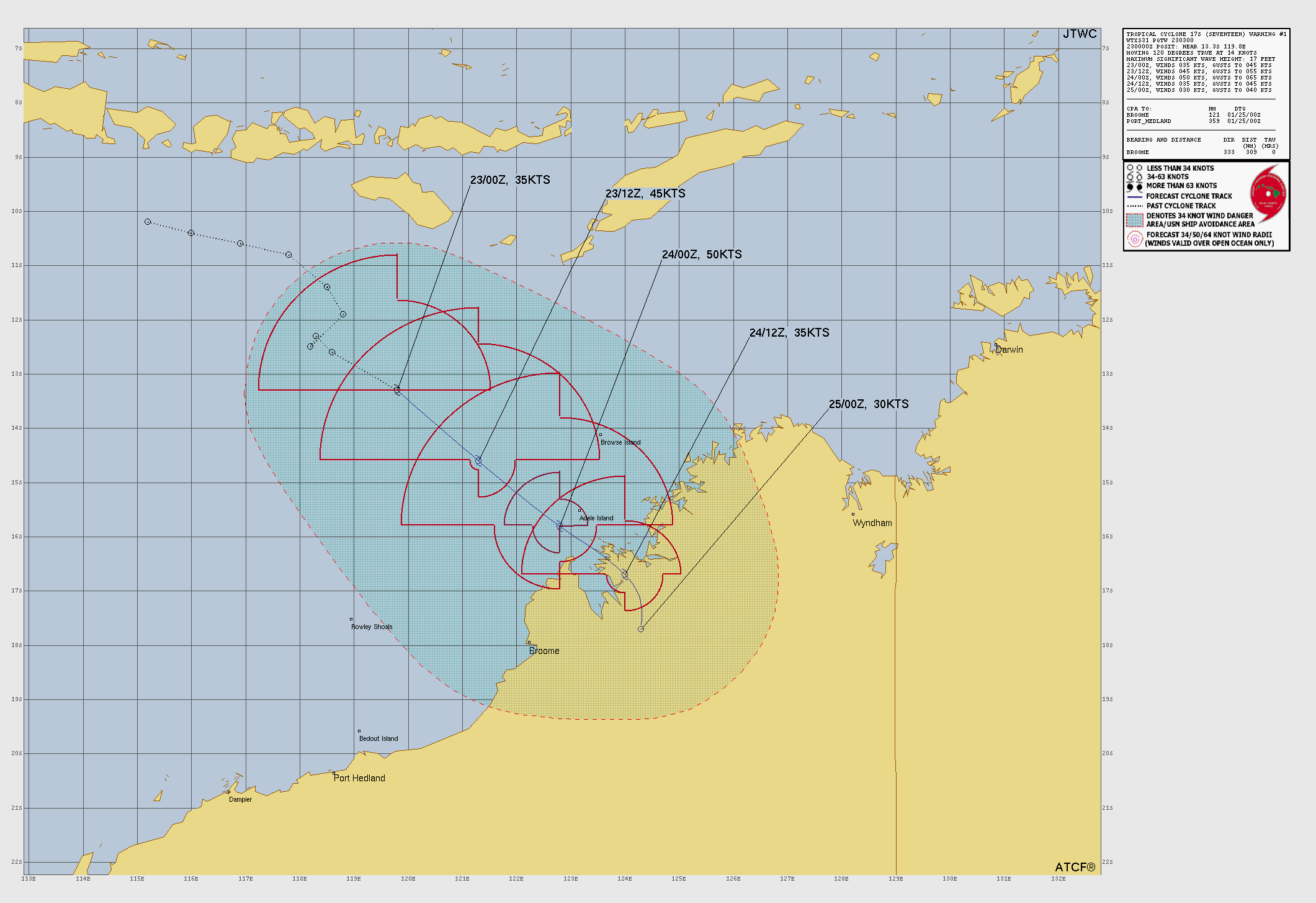
Tropical Storm Seventeen was located near 16°S, 121.4°E, or about 146 miles (236 km) north-northwest of Broome, Western Australia. Seventeen has maximum sustained winds of 45 knots and a minimum central pressure of 994 millibars.
Sea surface temperatures are around 29.5°C (85.1°F).
Invest 92P was located near 15.6°S, 141.7°E, or about 165 miles (266 km) east-northeast of Mornington Island, Queensland. 92P has maximum sustained winds of 30 knots and a minimum central pressure of 1002 millibars.
Sea surface temperatures are around 29.5°C (85.1°F).
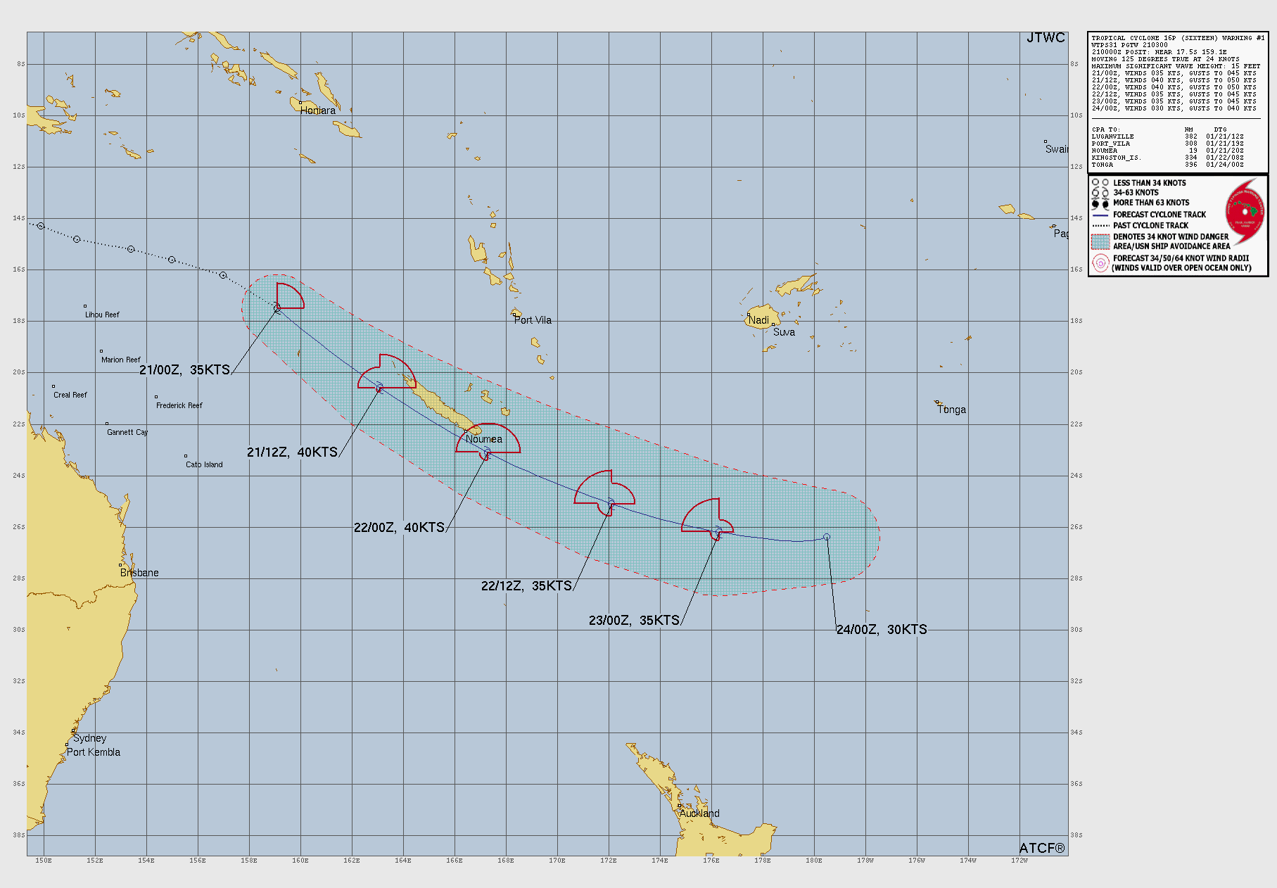
Subtropical Depression Sixteen was located near 26.7°S, 176.6°W, or about 395 miles (635 km) south-southwest of Tonga. Sixteen has maximum sustained winds of 25 knots and a minimum central pressure of 998 millibars.
Sea surface temperatures are around 26.5°C (79.7°F).
I literally don’t trust AI for the amount of times its been used for misinformation, but we could see this maybe happening, as GFS suggests an extremely weak low-pressure system, ICON suggests maybe some small development right at the end of its 180-hour range on the 12Z run, and some GEFS ensemble members say there will be a system with a pressure below 1010 mbar.
Force 13 Fanatic
7 months ago
EPAC Bulletin:
Invest 94E is looking better organized and is expected to become a tropical depression soon and later a strong tropical storm named Erick. Sea surface temperatures are really hot at 83° Fahrenheit (28.3° Celsius, 301 Kelvin) and the wind shear is low. Erick may be the first tropical storm to make landfall in the 2025 Pacific hurricane season, though we are not really sure.
One GFS Model Run from Tropical Tidbits is saying that Erick may even become a fully-fledged hurricane at a pressure down to 984 millibars or hectopascals (29.05 inches of Mercury).
This system will be monitored for any signs of development.
I predict 90mph 981mb. NHC also seemingly on board. Could bring quite a lot of rainfall to Mexico and western Guatemala as it either makes landfall or tracks along the coast.
In fact, GFS is calling for 965mb. GFS doing recent GFS things.
Hurricane
7 months ago
How is Dalila still a storm? There’s barely any clouds left!
That isn’t radar, that’s forecasted precipitation.
F0rce-23/FAN
7 months ago
(Hypothetical) Update 3 on the Atlantic Hurricane Season | System 15L is now 15 miles south of Barbados, and it appears to have reorganized. The current chance of formation within the next 2 days is 30%, and within the next 7 days, it is 50%. It has a current pressure of 1011.
F0rce-23/FAN
7 months ago
(Hypothetical)Update 2 on the Atlantic hurricane season | System 15L now has a 40% chance of formation, a windspeed of 25 miles an hour, a pressure of 1012, it is forecasted to drift north of the next week.
F0rce-23/FAN
7 months ago
(Hypothetical) Update 1 on the atlantic Hurricane Season. System 15L has begun to form near Cabo Verde, precisely 5 miles south of the islands, sustained windpseeds of 20 miles an hour, a millibar pressure of 1015.
F0rce-23/FAN
7 months ago
Day 13 of waiting for the atlantic to wake up so that I can report on it and get a popular youtube channel.
where did f0rce-23/fan go… i thought they were gonna be making updates on the current pacific activity
casualcyclonetrackerguy
7 months ago
The EPAC basin seems to be making a genuine comeback. I predict that we might actually reach the auxiliary name list if this streak of storms keeps going.
I wouldn’t be surprised if there were to be 10 storms at once by the peak of the Pacific typhoon/hurricane season.
F0rce-23/FAN
7 months ago
Pacific prediction #1: Disturbance 1 is going to form in 2 days, and is going to be the first to form into a tropical storm, disturbance 1 will draw energy from Disturbance 2, causing it to move towards Disturbance 1, where Disturbance 1 will drift north east and could make landfall in Mexico. The Third disturbance is still weak, but could head north in the near future.
So, about the Atlantic being inactive… Let’s take a look at the analog years: 1999, 2006, 2008, 2011, and 2017. 1999: Arlene formed June 11 2006: Alberto formed June 10 2008: Bertha formed July 3 (Arthur would’ve already started the season if today were 2008, forming May 31) 2011: Arlene formed June 28 2017: Bret formed June 19 (April storms are exceptionally rare, yes I’m talking about you Arlene)
This data shows that we might see 2025’s first named storm in mid-late June or early July.

 View more imagery Animated GIF
 View more precip products
 View more radar products Animated GIF
 View more SST products
 View more surface plot products


Google DeepMind AI ensemble is suggesting a possible low pressure area forming southeast of Bermuda on or around June 20, 2025.
I literally don’t trust AI for the amount of times its been used for misinformation, but we could see this maybe happening, as GFS suggests an extremely weak low-pressure system, ICON suggests maybe some small development right at the end of its 180-hour range on the 12Z run, and some GEFS ensemble members say there will be a system with a pressure below 1010 mbar.
EPAC Bulletin:
Invest 94E is looking better organized and is expected to become a tropical depression soon and later a strong tropical storm named Erick. Sea surface temperatures are really hot at 83° Fahrenheit (28.3° Celsius, 301 Kelvin) and the wind shear is low. Erick may be the first tropical storm to make landfall in the 2025 Pacific hurricane season, though we are not really sure.
One GFS Model Run from Tropical Tidbits is saying that Erick may even become a fully-fledged hurricane at a pressure down to 984 millibars or hectopascals (29.05 inches of Mercury).
This system will be monitored for any signs of development.
I predict 90mph 981mb. NHC also seemingly on board. Could bring quite a lot of rainfall to Mexico and western Guatemala as it either makes landfall or tracks along the coast.
In fact, GFS is calling for 965mb. GFS doing recent GFS things.
How is Dalila still a storm? There’s barely any clouds left!
Well, it does look like, by radar that the storm still has some precipitation left.
That isn’t radar, that’s forecasted precipitation.
(Hypothetical) Update 3 on the Atlantic Hurricane Season | System 15L is now 15 miles south of Barbados, and it appears to have reorganized. The current chance of formation within the next 2 days is 30%, and within the next 7 days, it is 50%. It has a current pressure of 1011.
(Hypothetical)Update 2 on the Atlantic hurricane season | System 15L now has a 40% chance of formation, a windspeed of 25 miles an hour, a pressure of 1012, it is forecasted to drift north of the next week.
(Hypothetical) Update 1 on the atlantic Hurricane Season. System 15L has begun to form near Cabo Verde, precisely 5 miles south of the islands, sustained windpseeds of 20 miles an hour, a millibar pressure of 1015.
Day 13 of waiting for the atlantic to wake up so that I can report on it and get a popular youtube channel.
We literally have the D storm in the Pacific and we haven’t even had an A storm in the Atlantic… That’s insane.
WUTIP JUST MADE LANDFALL ON HAINAN! EYEWALL REPLACEMENT?
POST-Tropical Cyclone Four-E? Are you sure about that?
I hope you’re joking, because it was a POTENTIAL tropical cyclone.
It was labeled on here as a Post-Tropical
where did f0rce-23/fan go… i thought they were gonna be making updates on the current pacific activity
The EPAC basin seems to be making a genuine comeback. I predict that we might actually reach the auxiliary name list if this streak of storms keeps going.
ooh!
well well well! would you look at that
LOL
Barbara and Cosme. Both have hurricane chances, and many forecasts show 92W forming this week. Finally, some action!
Barbara formed. It can be the first hurricane in EPAC this season
We could also get Cosme soon as well.
OK OK NOT THAT SOON-
Two vortexes developing at once
I wouldn’t be surprised if there were to be 10 storms at once by the peak of the Pacific typhoon/hurricane season.
Pacific prediction #1: Disturbance 1 is going to form in 2 days, and is going to be the first to form into a tropical storm, disturbance 1 will draw energy from Disturbance 2, causing it to move towards Disturbance 1, where Disturbance 1 will drift north east and could make landfall in Mexico. The Third disturbance is still weak, but could head north in the near future.
nahhh it begins now 😎
Now???
So, about the Atlantic being inactive… Let’s take a look at the analog years: 1999, 2006, 2008, 2011, and 2017.
1999: Arlene formed June 11
2006: Alberto formed June 10
2008: Bertha formed July 3 (Arthur would’ve already started the season if today were 2008, forming May 31)
2011: Arlene formed June 28
2017: Bret formed June 19 (April storms are exceptionally rare, yes I’m talking about you Arlene)
This data shows that we might see 2025’s first named storm in mid-late June or early July.
one of these forecast to be a cyclonic storm..
bro how did you change your profile picture-
THREE DISTURBANCES-
wait what? in the eastern pacific?
Yes one more could form behind these two in 6-10 days.