Late-Season Severe Weather Threatens the Deep South as Winter Weather Continues in the Midwest and Northeast

A large frontal system is keeping weather in the eastern two-thirds of the United States unsettled today. In the Deep South and southern Gulf Coast, under the warm sector of this system, dangerous severe weather is expected through the afternoon and evening, with severe thunderstorms forecast parts of the Lower Mississippi Valley into Alabama and the Tennessee Valley. In the cold sector of this system, dangerous winter weather is forecast from the Central Plains and Midwest into the Northeast through Tuesday.
Severe Weather Threat in the South
A dangerous severe weather situation is unfolding in the Deep South today, as an unusually warm and unsettled air mass moves in with a strong frontal system. Atmospheric conditions will be very favorable for the development of severe thunderstorms, many of which may be capable of producing significant tornadoes. The Weather Prediction Center (WPC) has issued a moderate risk of severe thunderstorms, along with a 10-15% probability of significant and potentially damaging tornadoes, from central Louisiana into central Mississippi, which includes the cities of Jackson, MS, and Alexandria, LA.
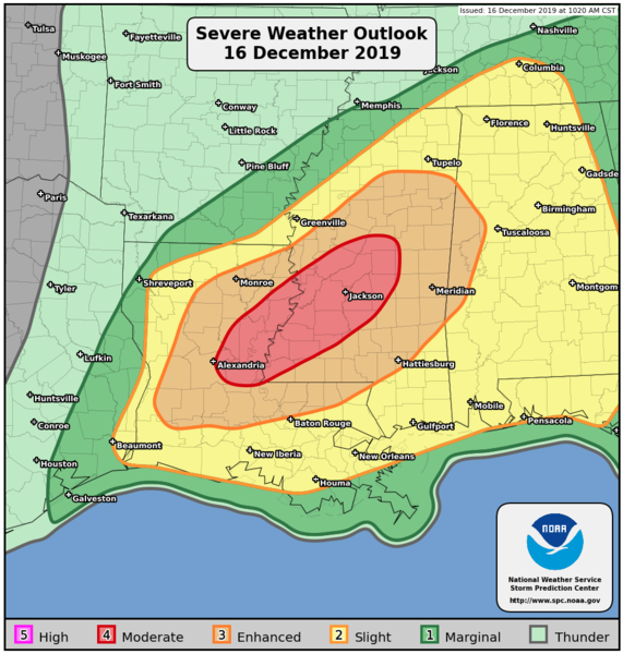
Close to the frontal system, a band of severe thunderstorms is forecast to evolve and strengthen, with a potential for numerous severe and supercell thunderstorms through the remainder of the evening. Many of these storms will be capable of producing strong winds, large hail, and tornadoes, some of which could be long-tracked and significant. Tornado watches are currently in effect for portions of southern and central Louisiana, central Mississippi, central and northern Alabama, and southern Tennessee. The greatest threat for significant tornadoes is from portions of central Louisiana into central Mississippi, including the cities of Alexandria, LA, Clinton, MS, Jackson, MS, Pearl, MS, and Vicksburg, MS.
If faced by a tornado threat, take cover immediately. Do not wait to see or hear a tornado, especially at night, when tornadoes are very difficult to see. The best place to be during a tornado threat is in the lowest floor or most interior room of a sturdy building, or within an underground storm shelter. Keep away from windows and doors, and take measures to protect yourself from flying debris. If you are outdoors, in a mobile home, or in a vehicle, move to the nearest substantial shelter and protect yourself from flying debris. If possible, be sure that pets and neighbors are secure, and be sure to keep an emergency kit with you if needed.
Please refer to your local National Weather Service (NWS) office or local news station for up-to-date information regarding this dangerous situation. NWS products and outlooks can be found on the web at https://www.weather.gov/.
Winter Weather Threat from the Central Plains to the Northeast
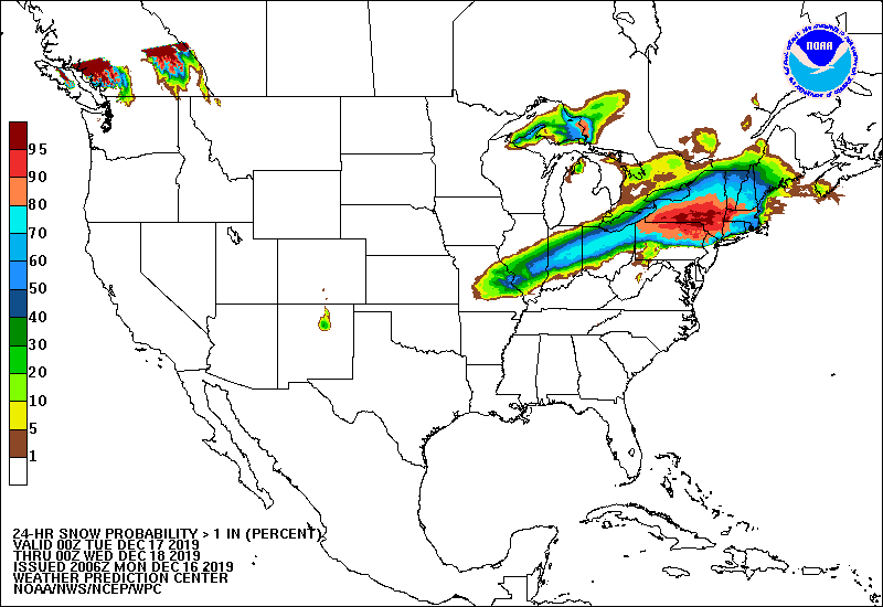
Ongoing winter weather will continue across the Central Plains and Midwest through tonight. The threat will shift into the Northeast on Tuesday, with locally heavy snowfall expected from the interior Northeast into New England. Winter weather advisories and warnings are currently in place from northwestern Oklahoma into New England. Snow will taper off tonight in portions of Oklahoma, Kansas, and Missouri as a swath of wintry precipitation forges northeastward through Illinois, Indiana, and Ohio. Mixed precipitation will arrive Tuesday morning in much of Pennsylvania and northern New Jersey, changing to snow later in the day as the system continues northeastward into New York and much of New England. In the Midwest, the highest snowfall accumulations are expected in central Illinois and Indiana, and in the Northeast, the highest accumulations are expected in interior New York and New England.
The forecasted winter weather is expected to make travel very difficult across the affected areas. Motorists are advised to plan on slippery road conditions for the Tuesday morning and evening commutes. If you plan on travelling, be sure to take precautions in the event of an emergency. For more information regarding this unfolding situation, refer to your local National Weather Service (NWS) office and local news and authorities. NWS products and outlooks can be found on the web at https://www.weather.gov/.
Force Thirteen US will be providing coverage on the severe weather and winter weather event occurring this week. For the latest updates and information, visit the Force Thirteen US Channel on YouTube. You can also find the latest information on Twitter @ForceThirteenUS.
