Laura expected to strengthen to a Category 4 hurricane before making landfall

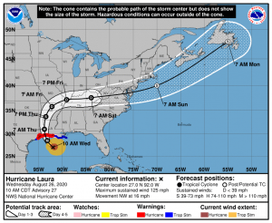
Hurricane Laura continues to rapidly strengthen, and as of 10:00 am CDT Hurricane Laura intensified further to a Category 3 major hurricane with sustained winds of 125 mph, and a minimum pressure of 956 millibars. Laura is currently moving towards the northwest at about 16 mph, and is expected to continue slowly recurving to the northeast throughout the next several days.
Timing and Impacts
Several mandatory evacuation orders have been issued for areas along the Texas/Louisiana border, including portions of Chambers, Jefferson, and Orange counties including the cities of Galveston and Port Arthur (Texas), as well as all of Cameron Parish, and portions of Jefferson, Lafourche, and Plaquemines parishes (Louisiana). Please follow instructions of local officials regarding evacuation orders.
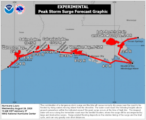
The exact landfall location of Laura is not known, but the forecast cone from the National Hurricane Center shows Hurricane Laura making landfall anywhere between High Island, TX and just east of Grand Chenier, LA very early tomorrow morning. The National Hurricane Center now forecasts Laura to reach Category 4 intensity with sustained winds of 145 mph at landfall, delivering over 15″ of rain in some isolated areas. Storm surge is predicted to reach catastrophic levels of 15-20 feet for areas between Johnson Bayou and Rockefeller Wildlife Refuge (Louisiana), and between 10-15 feet for areas extending westward to Sea Rim State Park, TX, and extending eastward to Intracoastal City, LA. A storm surge warning is currently in effect for all areas from Freeport, TX to the mouth of the Mississippi river, and a storm surge watch extends from the mouth of the Mississippi river to Ocean Springs, MS. A hurricane warning is in effect from San Luis Pass, TX to Intracoastal City, LA, and a hurricane watch extends from Intracoastal City, LA to just west of Morgan City, LA. The Storm Prediction Center also notes a 5% probability area for tornadoes across southern Louisiana in relation to Hurricane Laura.
Laura is expected to begin rapidly weakening after landfall, and is forecast to be down to a tropical storm as it’s center crosses the Louisiana/Arkansas border Thursday evening. Laura will continue recurving as it moves through Arkansas, Missouri, and the Ohio Valley as a tropical depression on Friday and Saturday before emerging off the Atlantic coast on Sunday. Laura is likely to be part of a frontal system by this point, although the National Hurricane Center has noted that there is a possibility for Laura to regenerate as a tropical storm in the Atlantic Ocean moving away from the United States.
Hurricane Shelter Information
COVID-19 will still be present as Hurricane Laura passes. Due to the pandemic, many evacuees are being evacuated to hotels in Central Texas and New Orleans, LA rather than schools that are usually designated as hurricane shelters. Many of these hotels are providing COVID-19 screening questions upon entry, and some are providing COVID-19 testing. Please check local area information and with local officials for more information on hurricane shelters.
