Tropical Storm Cosme forms off the Mexican Coast; Barbara Dissipates Over the Open North Pacific

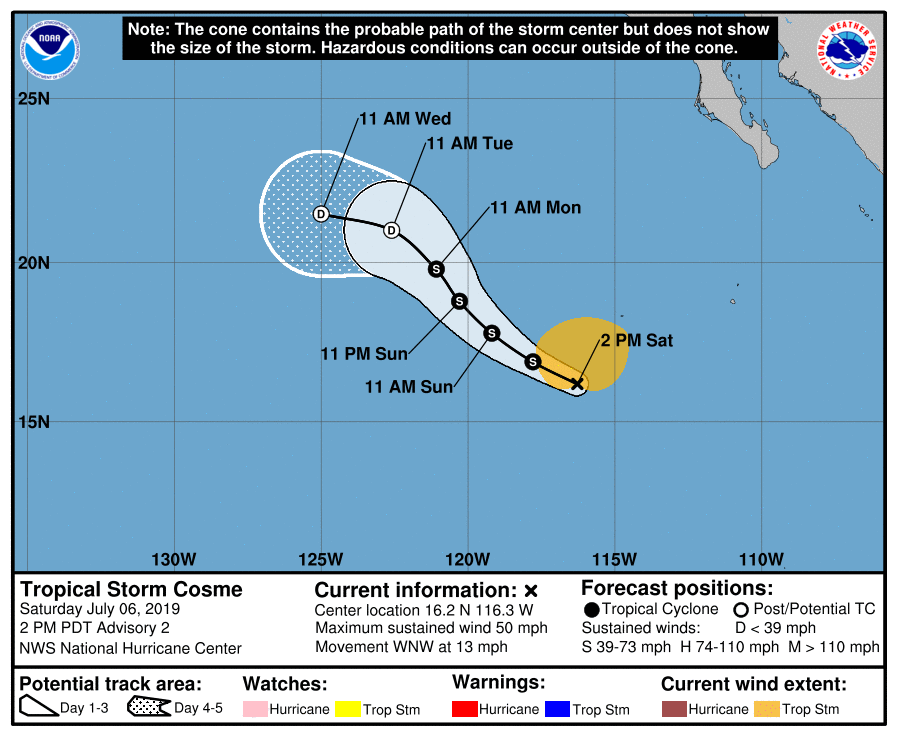
A broad area of low pressure (Invest 95E) which the National Hurricane Center (NHC) over the last several days has finally consolidated enough to be classified as a tropical storm. The NHC issued their first advisory on Tropical Storm Cosme at 8:00 AM PDT (15:00 UTC) on July 6, although the cyclone has changed little in organization since then. As of the most recent advisory at 2:00 PM PDT (21:00 UTC) July 6, the center of Tropical Storm Cosme was located near 16.2°N, 116.3°W, about 620 mi (1000 km) southwest of the southern tip of the Baja California Peninsula. Cosme had maximum sustained winds of 50 mph (85 km/h), gusting to 65 mph (100 km/h), and the minimum central pressure was 1001 mb (29.56 inches). The cyclone was moving west-northwestward at 13 mph (20 km/h), and Cosme is expected to turn northwestward today. Cosme is a large tropical cyclone, with tropical storm-force winds extending 160 miles (260 km). Currently, the NHC does not anticipate any intensification, as Cosme is being negatively affected by dry mid-level air, and has only about a day left over warm ocean waters. Weakening is expected to begin on Monday, and Cosme is forecast to degenerate into a remnant low by Tuesday as it moves over cool waters located off the Baja California Peninsula. This forecast is supported by most computer models, which show little to no intensification due to unfavorable conditions.
Saturday also saw the dissipation of the once-powerful Hurricane Barbara, which had been undergoing a weakening trend since Wednesday. After rapidly intensifying and nearly reaching Category 5 status on Tuesday, Hurricane Barbara began to weaken as it encountered a less favorable environment, marked by steadily decreasing sea surface temperatures and increasing wind shear. The cyclone lost major hurricane status on Thursday, and then weakened to a tropical storm on Friday as the cyclone was sheared apart. The National Hurricane Center issued their last advisory on Barbara at 5:00 AM HST (15:00 UTC) on Saturday, declaring the cyclone post-tropical after it had been devoid of deep convection for over 24 hours. As of 00:00 UTC July 7, Post-Tropical Cyclone Barbara was located at 18.3°N, 141.5°W. Maximum sustained winds were 45 mph (75 km/h), and the minimum central pressure was 1005 mb (29.68 inches). The remnants of Barbara are forecast to move westward to west-southwestward, passing close to the Hawaiian islands early next week. High Surf and Small Craft advisories are in effect for the islands, as Barbara is expected to enhance swells across the island chain through the weekend and into early next week. For more information on Barbara and its impact to the Hawaiian islands, visit the National Weather Service Honolulu website at https://www.weather.gov/hfo/.
For more information regarding current activity in the tropics, visit Force Thirteen’s official outlets. Live updates and daily Tropical Weather Bulletins can be found at the official Force Thirteen YouTube channel, and further information can be found on the Force Thirteen Twitter and Facebook pages.
