Tropical Storm Elsa nears Florida Coast, threat to entire US East Coast

[CURRENT STATUS]
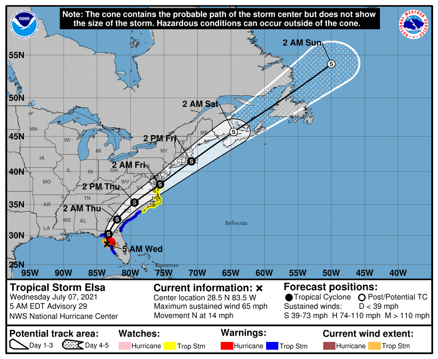
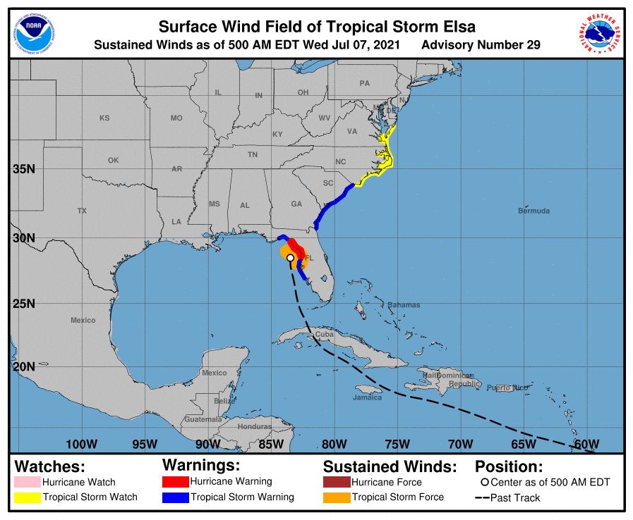
Hurricane Elsa slightly weakens as it becomes less organized. As per 5 AM EDT advisory of the National Hurricane Center. Elsa was located at 28.5N, 83.5W or about 50 miles (75 kilometers) South-Southwesr of Cedar Key, Fl, or about 70 miles (115 kilometers) West-Northwest of Tampa, FL with sustain winds of 65 mph, gusting up to 75 mph, minimum central pressure was estimated to be at 1004 millibars. The storm is currently moving North at speed of 14 mph. Latest Force Thirteen fix at 5 AM EDT is in agreement with the NHC.

[CURRENT WARNINGS]
A Storm Surge Warning (Danger of life-threatening inundation, from rising water moving inland from the coastline, in the indicated locations.): • West coast of Florida from Bonita Beach to the Aucilla River, including Tampa Bay A Hurricane Warning (Hurricane conditions are expected somewhere within the warning area, in this case within the next 12 hours.): • West coast of Florida from Chassahowitzka to the Steinhatchee River A Tropical Storm Warning (Tropical Storm conditions are expected somewhere within the warning area.): • West coast of Florida from south of Chassahowitzka to Englewood • West coast of Florida north of the Steinhatchee River to Ochlockonee River • Mouth of St. Marys River, Georgia to Little River Inlet, South Carolina A Storm Surge Watch (Possibility of life-threatening inundation, from rising water moving inland from the coastline, in the indicated locations.): • West of the Aucilla River to the Ochlockonee River, Florida A Tropical Storm Watch (Tropical Storm conditions are possible within the watch area.): • North of Little River Inlet, South Carolina to Duck, North Carolina • Pamlico and Albemarle Sounds
[OBSERVATIONS/REPORTS]
Florida Gov. Ron DeSantis expanded his state of emergency declaration on Tuesday to include a total of 33 counties as local, state and utility resources continue to prepare for the incoming storm. The Florida National Guard has activated 60 guardsmen to serve at the State Emergency Operations Center and Logistics Readiness Center, according to a release from the Guard. It is prepared to activate additional personnel as needed. “We are prepared here in the city of Tampa but we need you to do your part as well,” Tampa Mayor Jane Castor said in a video posted to Twitter. “Don’t go outside tonight. If you don’t have to, do not go outside. Stay in.” Duke Energy, which serves 1.8 million customers in Florida, according to its website, is preparing for anticipated outages from the storm. The storm threatens to impede the search and rescue effort at the site of the condominium building collapse in Surfside, near Miami, where crews have been sifting through rubble for 12 days in hopes of finding survivors. NASA and SpaceX have delayed the departure of the SpaceX CRS-22 Dragon cargo ship from the International Space Station (ISS) as Tropical Storm Elsa approaches Florida.

[FORECAST]
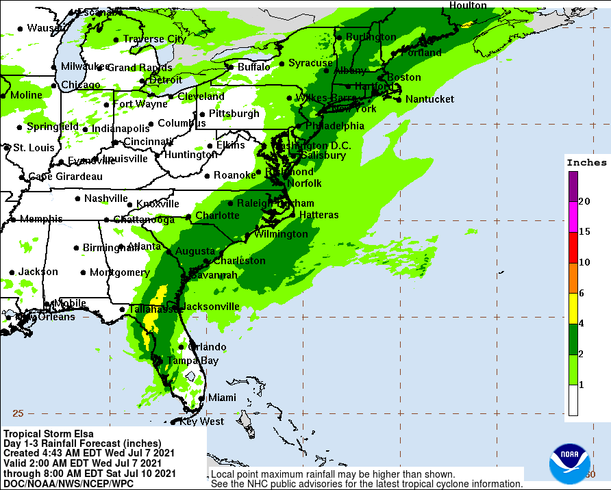
Hurricane conditions are expected within the Hurricane Warning area on the Florida Gulf coast during the next several hours. Tropical storm conditions are expected to spread northward into west-central Florida and the Florida Big Bend region in the warning areas tonight and early Wednesday. Tropical storm conditions are expected in the Tropical Storm Warning area along the Georgia coast by late Wednesday and along the South Carolina coast Wednesday night and early Thursday. The combination of a storm surge and the tide will cause normally dry areas near the coast to be flooded by rising waters moving inland from the shoreline. The water could reach the following heights above ground somewhere in the indicated areas if the peak surge occurs at the time of high tide: • Englewood, FL to Aucilla River including Tampa Bay: 3 to 5 ft • Bonita Beach, FL to Englewood, FL including Charlotte Harbor: 2 to 4 ft • Aucilla River to Ochlockonee River: 2 to 4 ft • Flamingo, FL to Bonita Beach, FL: 1 to 3 ft • Ochlockonee River to Indian Pass: 1 to 2 ft • Mouth of St. Marys River to South Santee River, SC: 1 to 2 ft Heavy rains associated with Tropical Storm Elsa will affect: • Across portions of Cuba through tonight: 1 to 3 inches, with isolated totals up to 15 inches. • Across Florida Keys into SW and W FL through Wednesday: 3 to 6 inches, with isolated totals up to 9 inches. • Across the rest of FL through Wednesday night: 2 to 4 inches, with localized totals up to 6 inches. • Across portions of SE GAand the Lowcountry of SC: 3 to 5 inches, with isolated totals up to 8 inches. • Across portions of NC into SE VA Wednesday night through Thursday night: 1 to 3 inches, with isolated totals up to 5 inches A few tornadoes are possible overnight across the western and central Florida Peninsula. The tornado threat will continue on Wednesday across north Florida, southeast Georgia, and eastern South Carolina. The tornado threat should shift to the eastern Carolinas and far southeast Virginia on Thursday. In the Mid-Atlantic, rainfall, particularly for Virginia Beach and the Delmarva Peninsula, will heavily depend on the western extent of the storm’s track, which is the subject of considerable uncertainty. Up to a few inches of rain are possible late Wednesday through Thursday night, along with strong gusty winds, minor coastal flooding, rough surf and rip currents. There is a growing potential of heavy rain, perhaps totaling two inches or greater, in southeast New York, Connecticut, Rhode Island and southeastern Massachusetts. The time frame to watch would be Friday. Tropical moisture streaming north ahead of Elsa may also enhance downpours over New York state and New England in the coming days, contributing to heavier totals.
[SOURCES]
Tropical Storm Elsa brings heavy winds and life-threatening storm surge as it nears landfall along Florida’s west coast: https://edition.cnn.com/2021/07/07/weather/hurricane-elsa-wednesday/index.html
