Tropical Storm Hanna was located near 33.7°N, 44.2°W, or about 826 miles (1329 km) west-southwest of Santa Cruz das Flores, Azores. Hanna has maximum sustained winds of 35 knots and a minimum central pressure of 1006 millibars.
Hurricane Nolo was located near 22.4°N, 164.2°W, or about 414 miles (666 km) west-northwest of Honolulu, Hawaii. Nolo has maximum sustained winds of 65 knots and a minimum central pressure of 984 millibars.
Hurricane Rachel was located near 17.3°N, 106.9°W, or about 210 miles (337 km) southwest of Manzanillo, Mexico. Rachel has maximum sustained winds of 70 knots and a minimum central pressure of 979 millibars.
Tropical Depression Nineteen-e was located near 13.8°N, 129.8°W, or about 1049 miles (1688 km) west-southwest of Clarion Island, Mexico. Nineteen-e has maximum sustained winds of 25 knots and a minimum central pressure of 1006 millibars.
ATCF®
- Latest Information -
As of September 30th 2026 at 08:31 UTC
Tropical Storm Surigae was located near 31.2°N, 138.3°E, or about 301 miles (485 km) south-southeast of Kyoto, Japan. Surigae has maximum sustained winds of 35 knots and a minimum central pressure of 1000 millibars.
Tropical Depression 26W was located near 15.8°N, 150.9°E, or about 441 miles (710 km) east-northeast of Hagåtña, Guam. 26W has maximum sustained winds of 30 knots and a minimum central pressure of 1001 millibars.
ATCF®
- Latest Information -
As of September 30th 2026 at 08:31 UTC
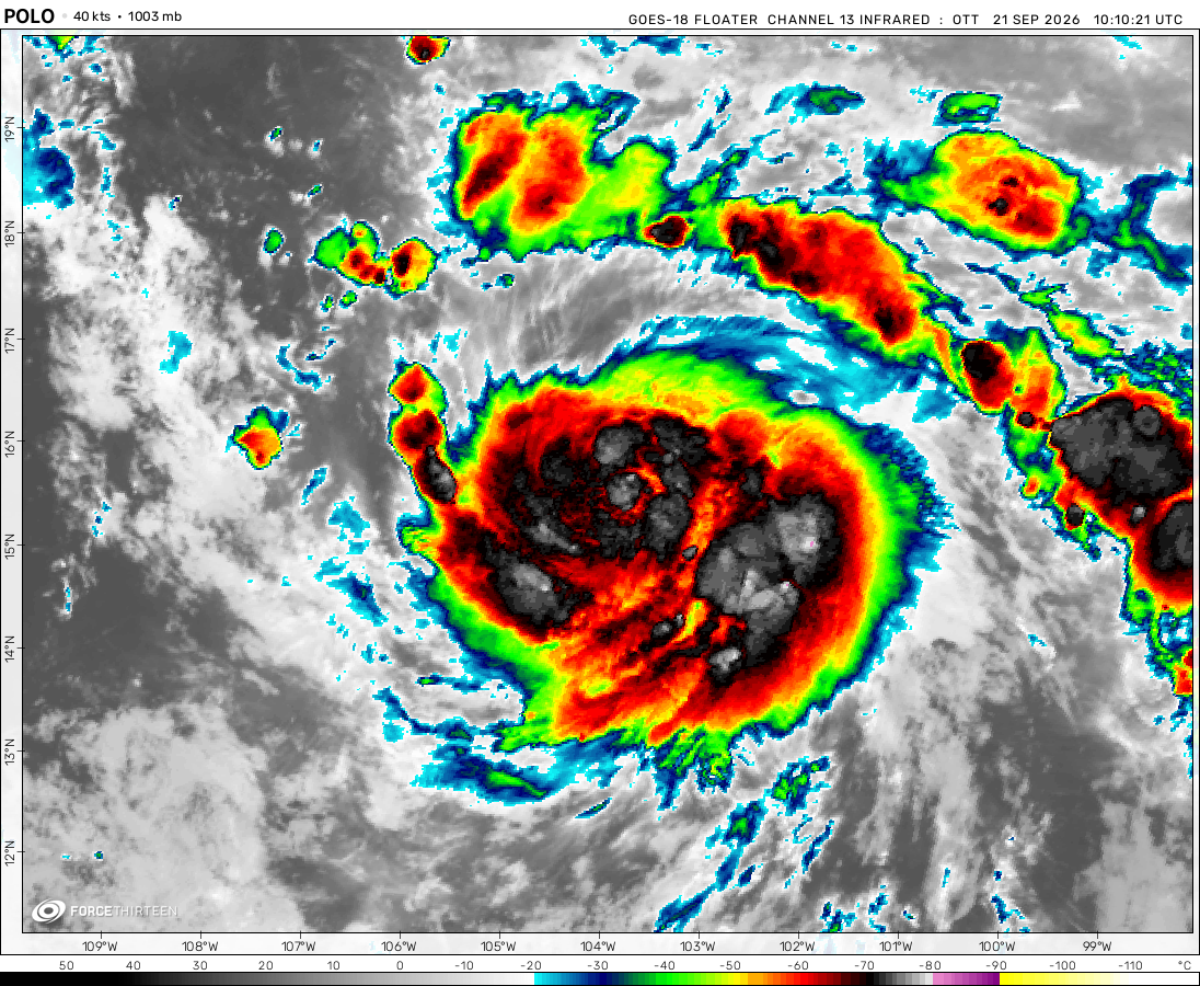
The remnants of Polo was located near 30.0°N, 108.5°W, or about 484 miles (779 km) north-northwest of Mazatlán, Mexico. Polo has maximum sustained winds of 30 knots and a minimum central pressure of 996 millibars.
The remnants of Fay was located near 23.9°N, 47.7°W, or about 1041 miles (1676 km) east-northeast of Pointe-à-Pitre, Guadeloupe. Fay has maximum sustained winds of 25 knots and a minimum central pressure of 1011 millibars.
Nevermind! I did a traceback and found Dora went further east!
WorldwideCycloneTracking
3 years ago
Hilary’s really strong now
Meranti
3 years ago
Fernanda is very strong now
William
3 years ago
Hone will likely form over the next few days, as the Eastern Pacific system moves into the Central Pacific.
Heeler Squad
3 years ago
Dora Is Dead Its No Longer A Tropical Cyclone
LFG0211
3 years ago
It’s like typhoon John all over again.
Heeler Squad
3 years ago
Dora Is Likely In The Western Pacific Right Now
I love Dora
3 years ago
I’ve got a theory…
(IF) Dora does reach near Japan would it be called Typhoon Dora or Cyclone Dora cause I never seen a hurricane reach that far, I actually find that impressive how long it is capable of lasting, not to mention its marathon track across the Pacific Ocean, Hats of to Dora
When a storm is at the Western Pacific, it is mandatory to have “Typhoon” next to its name. And I think Japan has it at “Typhoon No.7”. And other storms have reach the Western Pacific like John 1994, Enrique 1991, Hector 2018, Li 1994, Paka 1997, Oliwa 1997, Dora 1999, and others. and blud cyclones don’t exist in western pacific.
It was actually being monitored by the NHC 5 days previously to that in the central Atlantic (70% at peak consensus) but then it lost consensus before regaining it when mentioned above. Really impressive track if she goes really far.
No, they meant about 95-L (I think?) That died off, before getting a second (Brief) 10% in the Caribbean near Nicaragua, before moving over C. America and Reforming into the EPAC.
So It Basically went: Africa -> NATL -> Caribbean -> C. America -> EPAC -> CPAC -> WPAC
Cookies help us ensure our site works securely, continually make improvements, and personalize your browsing experience.
Click 'Accept All Cookies' to get the best browsing experience. You can change these settings at any time by clicking 'Manage My Cookies' below.
Functional
Always active
The technical storage or access is strictly necessary for the legitimate purpose of enabling the use of a specific service explicitly requested by the subscriber or user, or for the sole purpose of carrying out the transmission of a communication over an electronic communications network.
Preferences
The technical storage or access is necessary for the legitimate purpose of storing preferences that are not requested by the subscriber or user.
Statistics
The technical storage or access that is used exclusively for statistical purposes.The technical storage or access that is used exclusively for anonymous statistical purposes. Without a subpoena, voluntary compliance on the part of your Internet Service Provider, or additional records from a third party, information stored or retrieved for this purpose alone cannot usually be used to identify you.
Marketing
The technical storage or access is required to create user profiles to send advertising, or to track the user on a website or across several websites for similar marketing purposes.

 View more imageryAnimated GIF
 View more imageryAnimated GIF
 View more imageryAnimated GIF
 View more imageryAnimated GIF
 View more imageryAnimated GIF
 View more imageryAnimated GIF
And the remenats of hillary (as a trough/low/extratropical) might make it into eastern OR/ western ID
update: it’ll fling round’ canada and into the northeast
Also it kinda looks like the new WPAC system might be GREG regenerating…
*sigh* What was mentioned in last night’s TWB as a new system (the one towards jp) is really Dora reorganizing.
Yes
Yep Eugene…
Nevermind! I did a traceback and found Dora went further east!
Hilary’s really strong now
Fernanda is very strong now
Hone will likely form over the next few days, as the Eastern Pacific system moves into the Central Pacific.
Dora Is Dead Its No Longer A Tropical Cyclone
It’s like typhoon John all over again.
Dora Is Likely In The Western Pacific Right Now
I’ve got a theory…
(IF) Dora does reach near Japan would it be called Typhoon Dora or Cyclone Dora cause I never seen a hurricane reach that far, I actually find that impressive how long it is capable of lasting, not to mention its marathon track across the Pacific Ocean, Hats of to Dora
When a storm is at the Western Pacific, it is mandatory to have “Typhoon” next to its name. And I think Japan has it at “Typhoon No.7”. And other storms have reach the Western Pacific like John 1994, Enrique 1991, Hector 2018, Li 1994, Paka 1997, Oliwa 1997, Dora 1999, and others. and blud cyclones don’t exist in western pacific.
And it actually might as a depression! (TWB, August 17th)
And Dora is regenerating. Really is a strong one.
Dora has really high chance of going to WPAC.
Then getting destroyed at 160E by Extratropical 95W
Invest v C4: Invest WINS???
truth lol
now its lans outflow 😛
Wait you mean Lan?
If Dora makes it to the WPAC, it’s really ATL -> WPAC (this was monitored as a 10% atl/60% epac at first)
It was actually being monitored by the NHC 5 days previously to that in the central Atlantic (70% at peak consensus) but then it lost consensus before regaining it when mentioned above. Really impressive track if she goes really far.
More like the western atlantic (as a 10%)
No, they meant about 95-L (I think?) That died off, before getting a second (Brief) 10% in the Caribbean near Nicaragua, before moving over C. America and Reforming into the EPAC.
So It Basically went: Africa -> NATL -> Caribbean -> C. America -> EPAC -> CPAC -> WPAC
That’s exactly what I mean. Thanks Aiden.
Bruh i swear this gonna be active like 2018
ah yes, the WPAC being the WPAC.
do remember that we so far (except for sanvu) only got typhoon strength or higher here.
we don’t talk about Amang.
C4 Doksuri
C3 Doksuri!!! This storm is doing quite well!
HOW!?
more Storms about to come
More storms coming.
So far Typhoon Mawar has managed to outdo any Atlantic Hurricane in terms of maintained intensity of Category 5.