Tropical Storm Hanna was located near 33.7°N, 43.9°W, or about 811 miles (1306 km) west-southwest of Santa Cruz das Flores, Azores. Hanna has maximum sustained winds of 35 knots and a minimum central pressure of 1005 millibars.
Hurricane Nolo was located near 21.8°N, 164.2°W, or about 409 miles (658 km) west of Honolulu, Hawaii. Nolo has maximum sustained winds of 80 knots and a minimum central pressure of 974 millibars.
Tropical Depression Polo was located near 30.0°N, 108.5°W, or about 484 miles (779 km) north-northwest of Mazatlán, Mexico. Polo has maximum sustained winds of 30 knots and a minimum central pressure of 996 millibars.
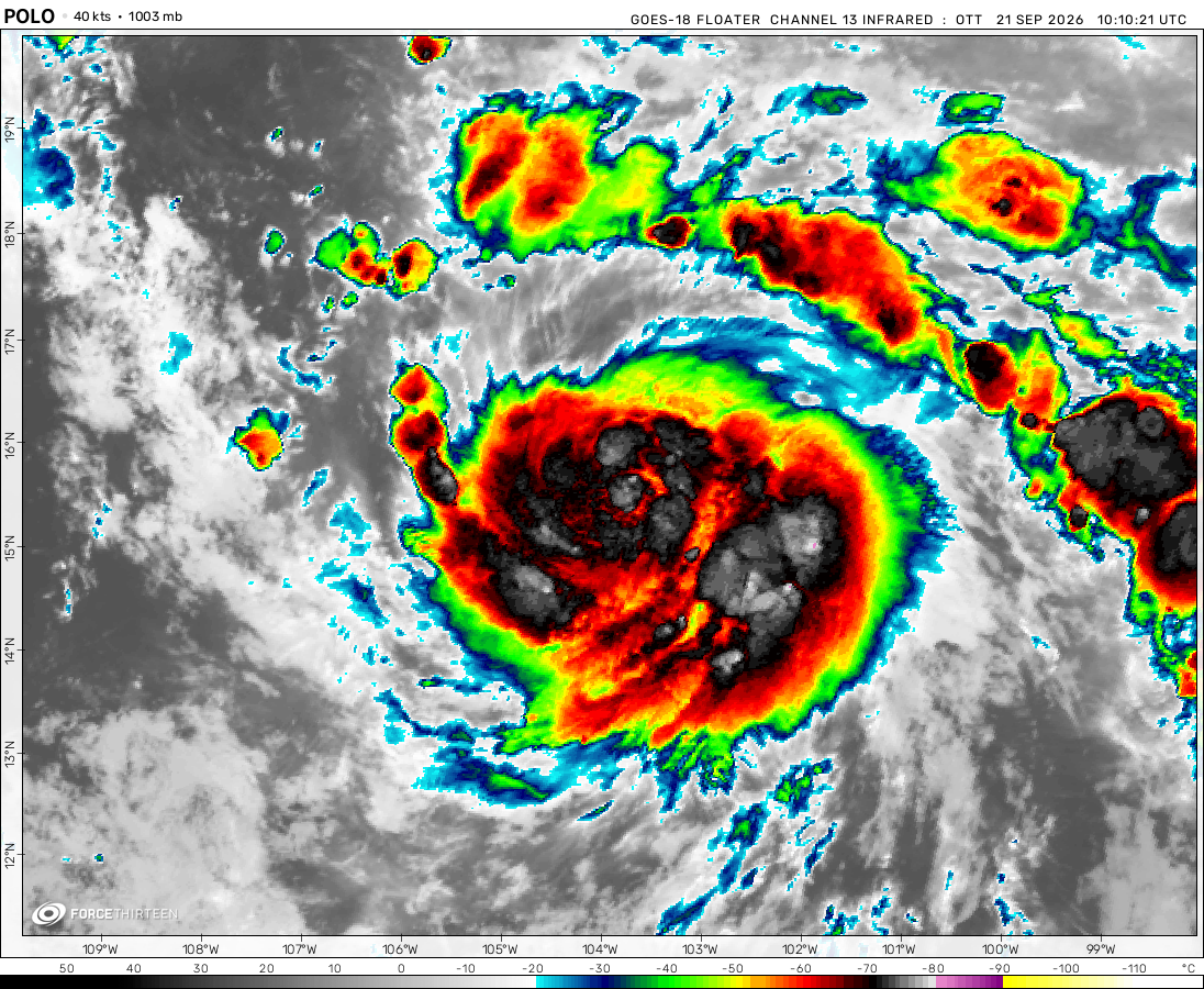
Tropical Storm Rachel was located near 16.6°N, 106.3°W, or about 216 miles (348 km) southwest of Manzanillo, Mexico. Rachel has maximum sustained winds of 60 knots and a minimum central pressure of 989 millibars.
Tropical Depression Nineteen-e was located near 13.9°N, 130.6°W, or about 1097 miles (1766 km) west-southwest of Clarion Island, Mexico. Nineteen-e has maximum sustained winds of 25 knots and a minimum central pressure of 1006 millibars.
ATCF®
- Latest Information -
As of September 30th 2026 at 05:47 UTC
Tropical Storm Surigae was located near 30.2°N, 137.3°E, or about 344 miles (554 km) south-southeast of Kyoto, Japan. Surigae has maximum sustained winds of 35 knots and a minimum central pressure of 1000 millibars.
Tropical Depression 26W was located near 15.7°N, 151.7°E, or about 489 miles (788 km) east-northeast of Hagåtña, Guam. 26W has maximum sustained winds of 25 knots and a minimum central pressure of 1005 millibars.
ATCF®
- Latest Information -
As of September 30th 2026 at 05:47 UTC
Tropical Depression Fay was located near 23.9°N, 47.7°W, or about 1041 miles (1676 km) east-northeast of Pointe-à-Pitre, Guadeloupe. Fay has maximum sustained winds of 25 knots and a minimum central pressure of 1011 millibars.
I knew I had a bad feeling about Kirk this year. I knew it from the beginning.
F0rce_23/fan
2 years ago
Why does it say there are no cyclones active? There are legit 3-5 cyclones/storm systems that are spinning all around Earth at this point!
Is the site broken?
Also, I’m good at writing information into documents and other resources.
I’ve written over 10-20 articles based on meteorology.
I’ve dreamed of becoming a meteorologist ever since elementary.
Do you think this should be my dream?
None of your thoughts about this will ever happen, just give me ideas about what could happen!
Hurricanes, or tornadoes, which one is more interesting?
It is probably not, but it can affect Britain, or maybe not since it is far from that.
Tropical remnants of Helene still spreading rain across East America.
ahh
2 years ago
Issac was stronger than people predicted, I wonder if it’ll even reach Category 3 status.
I’d still say somewhere from 500-750 miles wide at most.
Its eyewall is 20 miles wide, and it doesn’t seem to have formed a perfect eye because it got torn apart as soon as it hit land.
I’m surprised that the storm hasn’t dissipated quite yet.
My grandma was in hurricane Helene, she likely survived. She had canned food, clean water, water for the toilet, and electricity to survive.
StormTracker2024
2 years ago
ur cooked if ur in the way of this thing
Force 13 Forever (Cyclone Anggrek)
2 years ago
F13 Isaac is heading for you guys
FORCE13FANATIC
2 years ago
IF YOU CAN’T LEAVE, BRACE FOR IMPACT!!! GO TO THE BASEMENT!!! OR IF YOU DON’T HAVE A SAFE PLACE TO GO, JUST PRAY TO YOUR CENTER OF WORSHIP THAT THE STORM DOESN’T KILL YOU!!!
What if you’re in a hurricane with a tornado heading for you as well? UR COOKED!
FORCE13FANATIC
2 years ago
HOLY ****, HELENE IS A CATEGORY 3, POTENTIALLY CATASTROPHIC CATEGORY 4 MAJOR HURRICANE!!! EVERYONE LEAVE FLORIDA AND GEORGIA!!!
HURRICANEHUNTER
2 years ago
CODE RED, CODE RED
#CODE RED
F0rce_23/fan
2 years ago
Hurricane Helene
Currently a category 1 hurricane, it eventually moves northeast and rapidly intensifies!
By later tonight, it will strengthen further into category 2. After that, a couple hours in the morning it intensifies into a major hurricane being 100 or more miles away from Florida. As it creates its’ eye, it will finally strengthen into a category 4 and make landfall in the afternoon tomorrow towards late afternoon. And from there it will eventually drift further north east weaken and dissipate.
Cookies help us ensure our site works securely, continually make improvements, and personalize your browsing experience.
Click 'Accept All Cookies' to get the best browsing experience. You can change these settings at any time by clicking 'Manage My Cookies' below.
Functional
Always active
The technical storage or access is strictly necessary for the legitimate purpose of enabling the use of a specific service explicitly requested by the subscriber or user, or for the sole purpose of carrying out the transmission of a communication over an electronic communications network.
Preferences
The technical storage or access is necessary for the legitimate purpose of storing preferences that are not requested by the subscriber or user.
Statistics
The technical storage or access that is used exclusively for statistical purposes.The technical storage or access that is used exclusively for anonymous statistical purposes. Without a subpoena, voluntary compliance on the part of your Internet Service Provider, or additional records from a third party, information stored or retrieved for this purpose alone cannot usually be used to identify you.
Marketing
The technical storage or access is required to create user profiles to send advertising, or to track the user on a website or across several websites for similar marketing purposes.

 View more imageryAnimated GIF
 View more imageryAnimated GIF
 View more imageryAnimated GIF
 View more imageryAnimated GIF
 View more imageryAnimated GIF
 View more imageryAnimated GIF
Kirk is rapidly intensifying in the Atlantic, another major hurricane by the end of the week!
It has a chance of becoming a category 4 lol
It’s the end of the Atlantic, so many tropical storms…
Also sub to StormTracker2024 on YouTube.
Quit advertising!
Or yelling at others to subscribe to your channel, I subscribed anyways…
I wasn’t forcing anyone.
“I subscribed anyways”
I knew I had a bad feeling about Kirk this year. I knew it from the beginning.
Why does it say there are no cyclones active? There are legit 3-5 cyclones/storm systems that are spinning all around Earth at this point!
Is the site broken?
It’s prob because tropical tidbits and other things like that are down from Helene still.
Tropical depression/remnants Helene are finally dissipating!
I accidentally fell asleep making a Google document of updates on Super-typhoon Haiyan.
Also, I’m good at writing information into documents and other resources.
I’ve written over 10-20 articles based on meteorology.
I’ve dreamed of becoming a meteorologist ever since elementary.
Do you think this should be my dream?
None of your thoughts about this will ever happen, just give me ideas about what could happen!
Hurricanes, or tornadoes, which one is more interesting?
IT WAS A HYPOTHETICAL!!!
It is probably not, but it can affect Britain, or maybe not since it is far from that.
Tropical remnants of Helene still spreading rain across East America.
Issac was stronger than people predicted, I wonder if it’ll even reach Category 3 status.
Thats not possible because of the cold waters, i did not look at the conditions
Basically looks like the upper level moisture (13.5km+) is very low to support its further intensification
Helene is in Tennisee
Hurricane Helene is now one of the largest storms of 2024 and on record at 900-1,050 miles wide!
Largest: typhoon tip at 1,100 miles wide!
That’s not how you see the size of a storm. It’s based on the windfield only not the extent of its cloud cover
honest mistake. Windfield?
I’d still say somewhere from 500-750 miles wide at most.
Its eyewall is 20 miles wide, and it doesn’t seem to have formed a perfect eye because it got torn apart as soon as it hit land.
I’m surprised that the storm hasn’t dissipated quite yet.
Windfield means wind diameter where winds of the storm are felt , differs from rainfield
Now Helene has dissipated anyway
My grandma was in hurricane Helene, she likely survived. She had canned food, clean water, water for the toilet, and electricity to survive.
ur cooked if ur in the way of this thing
F13 Isaac is heading for you guys
IF YOU CAN’T LEAVE, BRACE FOR IMPACT!!! GO TO THE BASEMENT!!! OR IF YOU DON’T HAVE A SAFE PLACE TO GO, JUST PRAY TO YOUR CENTER OF WORSHIP THAT THE STORM DOESN’T KILL YOU!!!
Do not go to a basement it will flood first. go to basement during a tornado. Go to higher grownd in a Hurriane.
What if you’re in a hurricane with a tornado heading for you as well? UR COOKED!
HOLY ****, HELENE IS A CATEGORY 3, POTENTIALLY CATASTROPHIC CATEGORY 4 MAJOR HURRICANE!!! EVERYONE LEAVE FLORIDA AND GEORGIA!!!
CODE RED, CODE RED
#CODE RED
Hurricane Helene
Currently a category 1 hurricane, it eventually moves northeast and rapidly intensifies!
By later tonight, it will strengthen further into category 2. After that, a couple hours in the morning it intensifies into a major hurricane being 100 or more miles away from Florida. As it creates its’ eye, it will finally strengthen into a category 4 and make landfall in the afternoon tomorrow towards late afternoon. And from there it will eventually drift further north east weaken and dissipate.
It has a 10%-25% chance of becoming a category 5!
is it just me or does Helene look like Hurricane Micheal (2018) and Hurricane Ian (2022)
And a really severe Idalia
Yes, Ian’s daughter.
It will maximize category 4, aiming at Florida’s east Mexican coast. The footage I found on the weather website
Google Earth
Google earth or Zoom earth?
Zoom earth.
Helene is a C1
No, my grandma said she will stay in Florida I hope she survives! 🙏 🥺
She is in Mexico Beach directly in the path of the category 4 storm Helene…
EVERYBODY IN THE HURRICANE’S PATH NEAR FLORIDA OR GEORGIA MUST EVACUATE!!!
C3 peak
Still as dangerous as hurricane Katrina making landfall.