Tropical Storm Gonzalo was located near 13.7°N, 22.3°W, or about 118 miles (189 km) southeast of Praia, Cabo Verde. Gonzalo has maximum sustained winds of 45 knots and a minimum central pressure of 1004 millibars.
ATCF®
- Latest Information -
As of September 25th 2026 at 06:31 UTC
Hurricane Odalys was located near 17.3°N, 124.1°W, or about 621 miles (999 km) west of Clarion Island, Mexico. Odalys has maximum sustained winds of 100 knots and a minimum central pressure of 962 millibars.
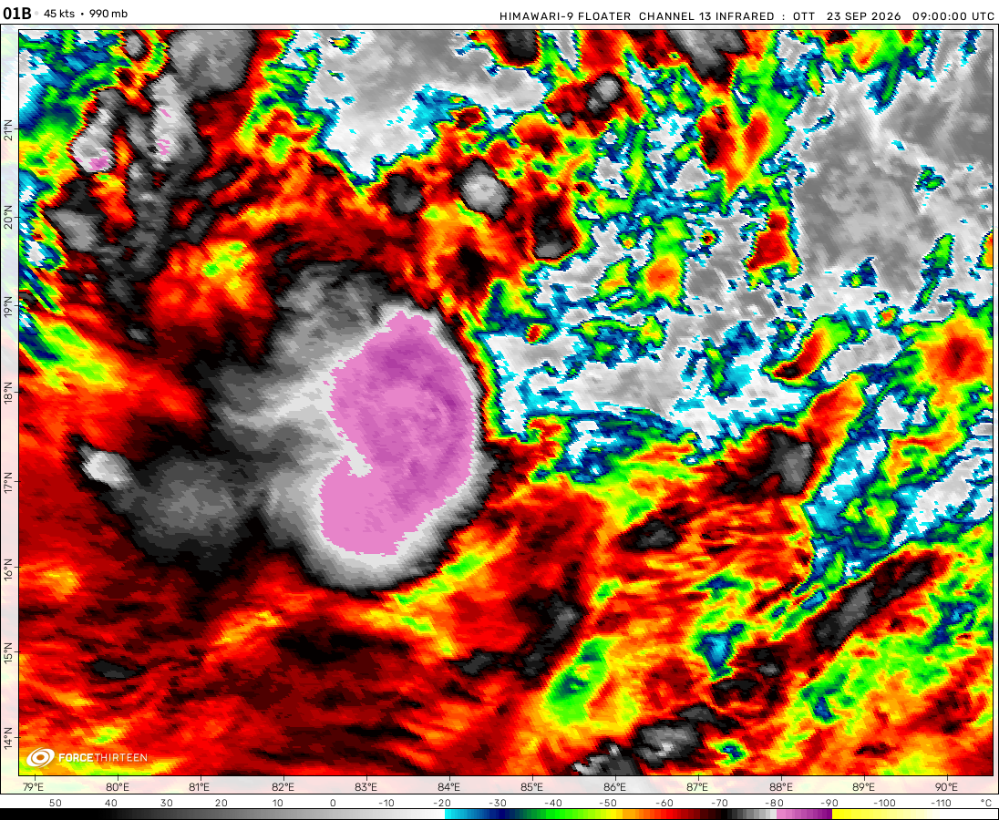
The remnants of 01B was located near 20.1°N, 82.8°E, or about 169 miles (272 km) north of Visakhapatnam, India. 01B has maximum sustained winds of 20 knots and a minimum central pressure of 994 millibars.
Tropical Storm Fay was located near 29.8°N, 42.1°W, or about 912 miles (1467 km) southwest of Santa Cruz das Flores, Azores. Fay has maximum sustained winds of 45 knots and a minimum central pressure of 1005 millibars.
Tropical Storm Nolo was located near 14.9°N, 156.0°W, or about 339 miles (545 km) south of Hilo, Hawaii. Nolo has maximum sustained winds of 60 knots and a minimum central pressure of 986 millibars.
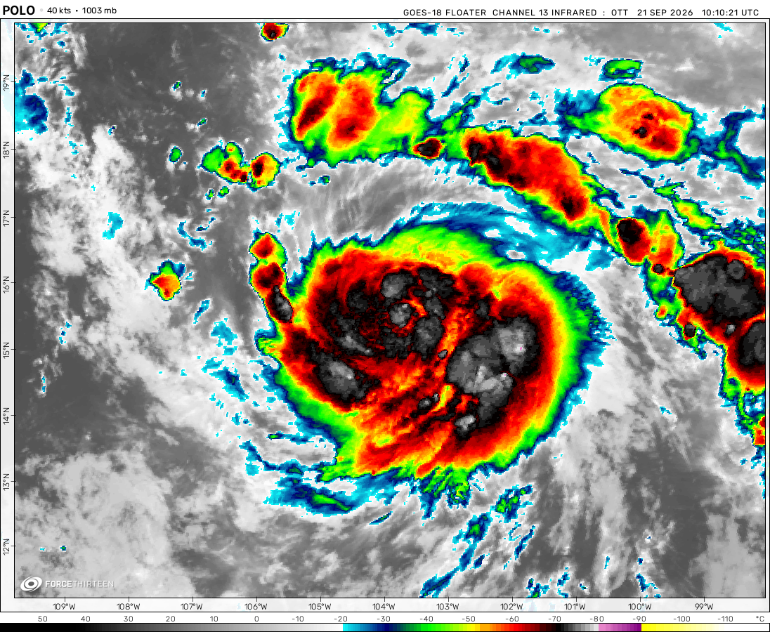
Hurricane Polo was located near 17.1°N, 106.1°W, or about 181 miles (291 km) southwest of Manzanillo, Mexico. Polo has maximum sustained winds of 130 knots and a minimum central pressure of 935 millibars.
Tropical Storm Surigae was located near 20.0°N, 130.5°E, or about 407 miles (655 km) south of Minami-Daitō Island, Japan. Surigae has maximum sustained winds of 40 knots and a minimum central pressure of 1003 millibars.
Invest 92W was located near 14.1°N, 102.5°E, or about 136 miles (219 km) east of Bangkok, Thailand. 92W has maximum sustained winds of 15 knots and a minimum central pressure of 1007 millibars.
Tracking Tropical Cyclones in Middle school is a waste of my time
I hope everyone can understand this, but I don’t have time for tracking cyclones on the website or on YouTube. Gaining subs is draining my energy that is supposed to be used for getting positive grades, school and education is all I need to focus on from now on, and until college I wont be tracking cyclones on YouTube and I wont be on here alot, but maybe a little bit I may come back here once in a while. Edit: I am going into 8th grade now, so it wont be long until I will be in highschool, and graduate to college, where I hope I can find a university that specializes in meteorology, I will finally have time to report on storms during college. Thanks for reading this.
Its not like I was updating frequently anyways, who would Subscribe to hurricane tracker that updates on hurricanes once a month? Besides, I wasn’t getting many views anyways.
casualcyclonetrackerguy
1 year ago
Just take a look at the image.
F0rce-23/FAN
1 year ago
I’M KIND OF MAD AT MY SCHOOL
You see, I was going to check out how the North Atlantic was doing on Zoom.earth, however, things did not go to plan. This is going to in the future effect how I track cyclones on YouTube. Also, Im back after a month, I went on vacation to Mexico beach, FL. My school blocked zoom.earth. That means it will be harder for me to discuss on this platform.
You may now disregard my previous statement, as it has fixed itself now.
Hurricane
1 year ago
This is the first time since 2021 that there have been 8 named WPAC storms by July 23, and the last season to have more at this time is 2018.
casualcyclonetrackerguy
1 year ago
What do you expect from this new disturbance? I personally think it has a chance of becoming a tropical storm or depression, but more likely than not a repeat of AL93.
casualcyclonetrackerguy
1 year ago
Ok, it literally got designated as an invest. I’m expecting a large increase in the formation chance on the next Tropical Weather Outlook from the NHC if it’s an invest.
casualcyclonetrackerguy
1 year ago
An Atlantic disturbance is seen
Our hurricane trackers are keen
The strength of this may not be known
All we know, the area is alone
Models call for not much development
Some ensemble members, way much more
If this is made an invest,
The hurricane models will implore
Plennyy
1 year ago
15Z, we would have first warning of wipha by JTWC
georgianguy_
1 year ago
Crising is about to be a tropical depression. PAGASA Confirm it. But others didn’t
It still rather look like a monsoon depression, still too large and unclosed
casualcyclonetrackerguy
1 year ago
WE LITERALLY HAVE THE EQUIVALENT OF A NORTHERN HEMISPHERIC JANUARY CYCLONE RIGHT NOW
(also I don’t speak French but I do know that “Activité cyclonique en cours” basically means “Active cyclones in progress”.)
GFS and ICON say it won’t intensify past this, but ECMWF is calling for restrengthening to 989mb… also GFS says Crising will dissipate in the Gulf of Tonkin, ECMWF is calling for it to strengthen to potentially a cat 3 there.
Base on the very stoned GFS forecast recently, another system would form in the next 4-5 days, Cat 4 equivalent and very massive, ECMWF is weaker, smaller, but have agreed track near toward Shanghai (WPAC)
Cookies help us ensure our site works securely, continually make improvements, and personalize your browsing experience.
Click 'Accept All Cookies' to get the best browsing experience. You can change these settings at any time by clicking 'Manage My Cookies' below.
Functional
Always active
The technical storage or access is strictly necessary for the legitimate purpose of enabling the use of a specific service explicitly requested by the subscriber or user, or for the sole purpose of carrying out the transmission of a communication over an electronic communications network.
Preferences
The technical storage or access is necessary for the legitimate purpose of storing preferences that are not requested by the subscriber or user.
Statistics
The technical storage or access that is used exclusively for statistical purposes.The technical storage or access that is used exclusively for anonymous statistical purposes. Without a subpoena, voluntary compliance on the part of your Internet Service Provider, or additional records from a third party, information stored or retrieved for this purpose alone cannot usually be used to identify you.
Marketing
The technical storage or access is required to create user profiles to send advertising, or to track the user on a website or across several websites for similar marketing purposes.

 View more imageryAnimated GIF
 View more imageryAnimated GIF
 View more imageryAnimated GIF
 View more imageryAnimated GIF
 View more imageryAnimated GIF
 View more imageryAnimated GIF
 View more imageryAnimated GIF
Tracking Tropical Cyclones in Middle school is a waste of my time
I hope everyone can understand this, but I don’t have time for tracking cyclones on the website or on YouTube. Gaining subs is draining my energy that is supposed to be used for getting positive grades, school and education is all I need to focus on from now on, and until college I wont be tracking cyclones on YouTube and I wont be on here alot, but maybe a little bit I may come back here once in a while.
Edit: I am going into 8th grade now, so it wont be long until I will be in highschool, and graduate to college, where I hope I can find a university that specializes in meteorology, I will finally have time to report on storms during college. Thanks for reading this.
Can I take on your Atlantic duty?
Sure
Its not like I was updating frequently anyways, who would Subscribe to hurricane tracker that updates on hurricanes once a month? Besides, I wasn’t getting many views anyways.
Just take a look at the image.
I’M KIND OF MAD AT MY SCHOOL
You see, I was going to check out how the North Atlantic was doing on Zoom.earth, however, things did not go to plan. This is going to in the future effect how I track cyclones on YouTube. Also, Im back after a month, I went on vacation to Mexico beach, FL. My school blocked zoom.earth. That means it will be harder for me to discuss on this platform.
I knew no one would care. Just looking for advice.
RECORD FLOODING in my area.
This pre-season for the southwestern Indian Ocean is insane. THIS IS THE EQUIVALENT OF A NORTHERN HEMISPHERE FEBRUARY CYCLONE.
H u h ? ?
T r o p i c a l D e p r e s s i o n a t N o r t h P o l e ? !
The ATCF is buggy, especially with its ≥200 mph estimate with Milton.
91.5 degrees North is impossible.
YAR HAR HAR
ruh roh
if this doesn’t develop into dexter i might actually crash out
I think we’re in for some CPAC hyperactivity.
Central Pacific drought? Nope!
NOTICE: Use the NHC website for formation chance information on 90C, as Zoom Earth may have some weird basin configurations for the Central Pacific.
You may now disregard my previous statement, as it has fixed itself now.
This is the first time since 2021 that there have been 8 named WPAC storms by July 23, and the last season to have more at this time is 2018.
What do you expect from this new disturbance? I personally think it has a chance of becoming a tropical storm or depression, but more likely than not a repeat of AL93.
Ok, it literally got designated as an invest. I’m expecting a large increase in the formation chance on the next Tropical Weather Outlook from the NHC if it’s an invest.
An Atlantic disturbance is seen
Our hurricane trackers are keen
The strength of this may not be known
All we know, the area is alone
Models call for not much development
Some ensemble members, way much more
If this is made an invest,
The hurricane models will implore
15Z, we would have first warning of wipha by JTWC
Crising is about to be a tropical depression. PAGASA Confirm it. But others didn’t
It still rather look like a monsoon depression, still too large and unclosed
WE LITERALLY HAVE THE EQUIVALENT OF A NORTHERN HEMISPHERIC JANUARY CYCLONE RIGHT NOW
(also I don’t speak French but I do know that “Activité cyclonique en cours” basically means “Active cyclones in progress”.)
GFS and ICON say it won’t intensify past this, but ECMWF is calling for restrengthening to 989mb… also GFS says Crising will dissipate in the Gulf of Tonkin, ECMWF is calling for it to strengthen to potentially a cat 3 there.
Base on the very stoned GFS forecast recently, another system would form in the next 4-5 days, Cat 4 equivalent and very massive, ECMWF is weaker, smaller, but have agreed track near toward Shanghai (WPAC)
Nari is over…